Texas State Highway Loop 275
Loop 275 is a 9.454-mile (15.215 km), two-segment state-maintained roadway located in Austin, Texas.
| ||||
|---|---|---|---|---|
 | ||||
| Route information | ||||
| Length | 9.5 mi[1] (15.2 km) | |||
| Existed | 1939–present | |||
| Major junctions | ||||
| South end | ||||
| North end | ||||
| Highway system | ||||
| ||||

History
Loop 275 was originally formed on March 24, 1954, when US 81 was realigned to form the Interregional Highway, which would later form the initial alignment for Interstate 35 (I-35). The route was also signed as US 81 Business. On February 25, 1975, Loop 275 was no longer planned to be US 81 Business.[1]
At that time, Loop 275 followed Lamar Boulevard to where Guadelupe splits from Lamar at the Y-intersection. From there, it followed Guadalupe Street and 1st Street over to Congress Avenue, where it crossed the Colorado River at the Ann W. Richards Congress Avenue Bridge and then continued south to eventually rejoin I-35.
Lamar Boulevard and Congress Avenue are main arterial roads through Austin, and on July 11, 1986, maintenance of the central segments of those roads (from US 183 to US 290) was returned to the city of Austin at its request. This resulted in the two-segment configuration of Loop 275 seen today. On February 24, 2000, the section of Loop 275 from US 290 to Williamson Creek was returned to the city of Austin at its request.
Route description
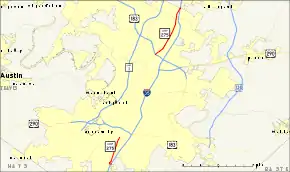
As currently configured, Loop 275 consists of two non-connected segments. The 6.0-mile (9.7 km) northern segment starts at an interchange at US 183, just west of Interstate 35. It proceeds north along Lamar Boulevard, passing FM 734, before terminating at the southbound frontage road of Interstate 35, just south of Howard Lane (Exit #246).
The 3.2-mile (5.1 km) southern segment starts at an intersection with Slaughter Lane just west of Interstate 35 (Exit #226B/227). It proceeds north along South Congress Avenue to its terminus at Williamson Creek south of US 290.
Junction list
The entire route is in Austin, Travis County.
| mi | km | Destinations | Notes | ||||
|---|---|---|---|---|---|---|---|
| Slaughter Lane | |||||||
| Bridge over Williamson Creek | |||||||
| Gap in route | |||||||
| 1.000 mi = 1.609 km; 1.000 km = 0.621 mi | |||||||
References
- Transportation Planning and Programming Division (n.d.). "State Highway Loop No. 275". Highway Designation Files. Texas Department of Transportation. Retrieved 2007-08-02.