U.S. Route 183 in Texas
U.S. Route 183 (US 183) is a north-south U.S. highway that begins in Texas in Refugio at an intersection with US 77 (Future I-69E) concurrent with US 77 Alt. The highway runs through many small communities with Austin being the only major city along its route. The highway exits Texas concurrent with US 70, crossing into Oklahoma.
| ||||
|---|---|---|---|---|
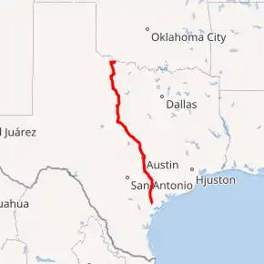
US 183 highlighted in red | ||||
| Route information | ||||
| Maintained by TxDOT | ||||
| Length | 428.382 mi (689.414 km) | |||
| Major junctions | ||||
| South end | ||||
| North end | ||||
| Location | ||||
| Counties | Refugio, Goliad, DeWitt, Gonzales, Caldwell, Travis, Williamson, Burnet, Lampasas, Mills, Brown, Eastland, Stephens, Throckmorton, Baylor, Wilbarger | |||
| Highway system | ||||
| ||||

Route description
US 183 begins concurrent with US 77 Alt at its southern terminus one block north of downtown Refugio at an intersection with US 77; the two highways subsequently travel north through mostly rural farmlands across the Gulf Coastal Plains. After serving the Presidio La Bahía, US 183 crosses the San Antonio River to serve the Goliad State Park and Historic Site and the city of Goliad, intersecting US 59 in the center of town. Traveling through additional farmlands and forests, US 183 eventually forms a concurrency with US 87 just before crossing the Guadalupe River and travels along Espalande Street through downtown Cuero, ending its concurrency of US 87 in the town center. North of Cuero, US 77 Alt splits off to the northeast, while US 183 continues parallel to the Guadalupe River's course. The highway cuts through the historic Battle of Gonzales site and borders the city of Gonzales to the west, intersecting US 90 Alt to the northwest of the city. Running parallel to the San Marcos River, US 183 provides access to Palmetto State Park before crossing I-10 and forming a concurrency with US 90 west to Luling via Pierce Street. In the center of Luling, US 183 leaves US 90 and turns onto Magnolia Avenue, traveling due north past many decorated oil wells.
Continuing through rural farmlands, US 183 eventually enters Lockhart, being the main north-south route through the city. The highway then merges onto the SH 130 frontage roads just north of Lockhart, following them until Mustang Ridge where SH 130 splits northeast to follow SH 45 and US 183 continues north into Colton and Pilot Knob. As US 183 crosses into Austin and intersects several local roads providing access to McKinney Falls State Park, it borders the west side of Austin-Bergstrom International Airport before having an interchange with SH 71 and enters Austin's Montopolis district. US 183 crosses the Colorado River adjacent to the old Montopolis truss bridge prior to serving a major fork east of the Govalle district, making a sigmoid curve east to serve the Colony Park district. US 183 eventually becomes a six-lane freeway north of the Windsor Park district just before crossing US 290, curving west to serve I-35 and Loop 275 (Lamar Boulevard); north of Lamar Boulevard, US 183 is redesignated as Research Boulevard throughout the rest of its length in Austin. The highway makes another sigmoid curve to the north before an interchange with Loop 1 (Mopac Expressway).
After an interchange with Loop 360 (Capital of Texas Highway), US 183 serves much of northwest Austin. It eventually intersects SH 45 near Lakeline Mall and becomes a surface street while the freeway continues on the east side as 183A Toll Road. US 183 continues as Bell Boulevard through west Cedar Park before intersecting 183A in Leander. Continuing north, US 183 runs mostly through forests and farmland as it crosses the North and South Forks of the San Gabriel River. After turning through several hills east of the Texas Hill Country, US 183 bounds northwest into Lampasas, where it runs on Key Avenue concurrent with US 190 and US 281 through fourteen blocks in the city's downtown and recreational areas before splitting to the northwest from US 281 north of Lampasas.
US 183 and US 190 continue traveling northwest through rolling hills, eventually splitting southeast of the Lometa city limits. US 183 continues to run parallel to the Colorado River before beginning a concurrency with US 84 north of the Goldthwaite city limits. The two highways continue northwest for a long distance before reaching Early and joining US 67 and US 377 at the town's center. The four highways travel west for roughly eleven blocks before US 183 splits to the north and serves Brownwood Regional Airport. US 183 continues due north, crossing SH 36 in Rising Star and later I-20 just south of Cisco.
South of Throckmorton, US 283 joins the highway, an overlap that lasts until Vernon, where 183 joins US 70 and US 287. In Oklaunion, US 70 and 183 leave US 287 and cross the Red River together into Oklahoma.
History
Research Boulevard, Anderson Lane, and Ed Bluestein Boulevard in Austin
Bergstrom Expressway | |
|---|---|
| Location | Austin |
| Existed | 2019–present |
Through 1990, none of US 183 through Austin was built to freeway standards. By 2002, the portion of US 183, known as Research Boulevard, had been upgraded to a freeway. At that time, Research Boulevard, between Spicewood Springs Road and Cameron Road, was built as a viaduct with grade separated limited access. The northern freeway portion between Spicewood Springs Road and Bell Boulevard in Cedar Park, was completed by 2003.[1]
The southern freeway portion between Cameron Road and US 290, became completed in 2002.
In Cedar Park, the limited access portion of Research Boulevard would become the 183A Toll Road, as US 183 would serve as a major arterial through the city as Bell Boulevard. The toll road opened in March 2007. The roads rejoin north of Leander.
In 2015, it was announced work would start on the conversion of the then-55-year-old portion of US 183 from US 290 to SH 71 into a three-to-five-lane tollway. The traffic lights at 51st Street, Techni Center Drive, Bolm Road (formerly a diamond interchange), Vargas Road, and Thompson Lane were all removed. In addition to these changes, an interchange at Patton Avenue is being constructed, the pedestrian crossing bridge just south of Manor Road will be upgraded, and Montopolis Bridge was decommissioned in favor of a new truss bridge that will serve as a pedestrian walkway, no longer open to motorized traffic.[2] Construction began in early 2016 with expected completion in late 2019 or early 2020.[3] The first section of the tollway opened on July 31, 2019, at which point the rest of the project was to be completed by late 2020.[4]
Major intersections
All exits are unnumbered.
| County | Location | mi | km | Destinations | Notes | ||
|---|---|---|---|---|---|---|---|
| Refugio | Refugio | 0.00 | 0.00 | Southern terminus; south end of US 77 Alt. overlap; U.S. 77 is the future Interstate 69E | |||
| | |||||||
| Goliad | | South end of SH 239 overlap | |||||
| | |||||||
| | |||||||
| | |||||||
| Goliad | North end of SH 239 overlap; U.S. 59 is the future Interstate 69W | ||||||
| | |||||||
| | |||||||
| Weser | |||||||
| DeWitt | Upper Meyersville | ||||||
| | |||||||
| Cuero | South end of US 87 overlap | ||||||
| North end of US 87 overlap | |||||||
| | North end of US 77 Alt. overlap | ||||||
| Concrete | |||||||
| Hochheim | |||||||
| Gonzales | | ||||||
| | |||||||
| Gonzales | South end of SH 97 overlap | ||||||
| north end of SH 97 overlap | |||||||
| Ottine | |||||||
| Caldwell | Luling | I-10 exit 632 | |||||
| South end of US 90 overlap | |||||||
| North end of US 90 overlap; south end of SH 80 overlap | |||||||
| North end of SH 80 overlap | |||||||
| | |||||||
| Lockhart | South end of FM 20 overlap | ||||||
| North end of FM 20 overlap | |||||||
| SH 130 exit 470; no direct access from US 183 south to SH 130 north or SH 130 south to US 183 north; South end of SH 130 overlap | |||||||
| | SH 130 exit 469 | ||||||
| Mendoza | Briarpatch Road / Homannville Trail | SH 130 exit 465 | |||||
| Mustang Ridge | SH 130 exit 463 | ||||||
| Travis | Old Lockhart Road | SH 130 exit 460 | |||||
| SH 130 exits 457 and 460; no direct access rom US 183 north to SH 130 south or SH 130 north to US 183 south; North end of SH 130 overlap | |||||||
| | |||||||
| Pilot Knob | |||||||
| Austin | McKinney Falls Parkway - McKinney Falls State Park | ||||||
| South end of tollway | |||||||
| Access point | |||||||
| Montopolis Bridge over the Colorado River | |||||||
| Non-tolled interchange and access point | |||||||
| Bolm Road | Interchange closed permanently on October 5, 2018;[5] U-turns remained open until late December 2019 | ||||||
| Access point; incomplete access to Bolm Road and Techni Center Drive is signed in both directions | |||||||
| Non-tolled interchange and access point; no direct southbound entrance to the toll road | |||||||
| Access point | |||||||
| Manor Road / Springdale Road | North end of tollway; south end of freeway; no direct southbound entrance to the toll road | ||||||
| No direct exits to US 290 west (signed northbound at Manor Road and southbound at Cameron Road) | |||||||
| Cameron Road | |||||||
| I-35 exits 240A-B | |||||||
| Georgian Drive / Northcrest Boulevard | No direct northbound exit or southbound entrance (signed at I-35); full access to Gessner Drive | ||||||
| No direct northbound exit or southbound entrance (signed at I-35) | |||||||
| Ohlen Road / Payton Gin Road | Full access to Anderson Square, Jamestown Drive, and Fairfield Drive | ||||||
| Great Hills Trail | Direct southbound entrance only (northbound exit signed at Capital of Texas Highway; southbound exit signed at Braker Lane) | ||||||
| Access to Seton Northwest Hospital | |||||||
| Balcones Woods Drive | No direct exits or entrances (northbound exit signed at Braker Lane; southbound exit signed at Duval Road) | ||||||
| Duval Road | |||||||
| Oak Knoll Drive | |||||||
| Williamson | McNeil Drive / Spicewood Springs Road | Full access to Pond Springs Road | |||||
| Anderson Mill Road | No direct southbound exit (signed at Lake Creek Parkway) | ||||||
| Lake Creek Parkway / Pecan Park Boulevard | |||||||
| No direct northbound exit to RM 620 (signed at Lake Creek Parkway) | |||||||
| North end of freeway; interchange with Lakeline Mall Drive southbound; at-grade intersection northbound | |||||||
| Austin–Cedar Park line | |||||||
| Cedar Park | |||||||
| Leander | |||||||
| West Broade Street | former RM 2243 west | ||||||
| Liberty Hill | |||||||
| | |||||||
| | |||||||
| | |||||||
| | |||||||
| Burnet | | ||||||
| Briggs | |||||||
| Watson | |||||||
| Lampasas | Lampasas | South end of US 190 / US 281 Truck overlap | |||||
| north end of US 281 Truck overlap; south end of US 281 overlap | |||||||
| South end of FM 580 overlap | |||||||
| North end of FM 580 overlap | |||||||
| North end of US 281 overlap | |||||||
| | |||||||
| Lometa | North end of US 190 overlap | ||||||
| Mills | Goldthwaite | South end of SH 16 overlap | |||||
| South end of US 84 overlap | |||||||
| see US 84 | |||||||
| Brown | Brownwood | North end of US 67 / US 84 / US 377 overlap | |||||
| | |||||||
| | |||||||
| May | |||||||
| | |||||||
| Eastland | Rising Star | ||||||
| | |||||||
| Pleasant Hill | South end of FM 2526 overlap | ||||||
| North end of FM 2526 overlap | |||||||
| Cisco | I-20 exit 332 | ||||||
| South end of SH 6 overlap | |||||||
| North end of SH 6 overlap | |||||||
| | |||||||
| | |||||||
| Stephens | | ||||||
| | South end of FM 576 overlap | ||||||
| | North end of FM 576 overlap | ||||||
| | |||||||
| Breckenridge | |||||||
| | |||||||
| | |||||||
| Throckmorton | | ||||||
| Woodson | South end of FM 209 overlap | ||||||
| North end of FM 209 overlap | |||||||
| | |||||||
| | South end of US 283 overlap | ||||||
| | |||||||
| Throckmorton | south end of SH 79 overlap | ||||||
| north end of SH 79 overlap | |||||||
| Baylor | Seymour | South end of US 277 overlap | |||||
| interchange | |||||||
| interchange | |||||||
| interchange | |||||||
| interchange; south end of US 82 overlap | |||||||
| Mabelle | North end of US 82 / US 277 overlap | ||||||
| Wilbarger | | ||||||
| | |||||||
| | South end of FM 433 overlap | ||||||
| | North end of FM 433 overlap | ||||||
| Vernon | |||||||
| interchange; north end of US 283 overlap; south end of US 70 / US 287 overlap | |||||||
| see US 287 | |||||||
| Oklaunion | interchange; north end of US 287 overlap | ||||||
| | |||||||
| | |||||||
| | 428.382 | 689.414 | Continuation into Oklahoma | ||||
1.000 mi = 1.609 km; 1.000 km = 0.621 mi
| |||||||
See also
 U.S. Roads portal
 Texas portal
- 183A Toll Road
References
- "US183 (Research Blvd. and Bluestein Blvd.)". texasfreeway.com/austin/photos/183/183.shtml. January 19, 2002.
- "Major Activity - 183 South". Archived from the original on October 14, 2018.
- "Maps - 183 South". Archived from the original on September 18, 2016. Retrieved September 12, 2016.
- Denney, Amy (July 30, 2019). "First phase of US 183 South toll project in East Austin opens July 31". impact. Retrieved April 4, 2020.
- "Archived copy". Archived from the original on 2018-10-14. Retrieved 2018-10-13.CS1 maint: archived copy as title (link)
External links
| Wikimedia Commons has media related to U.S. Route 183 in Texas. |
| Previous state: Terminus |
Texas | Next state: Oklahoma |