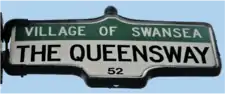
The Queensway
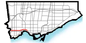
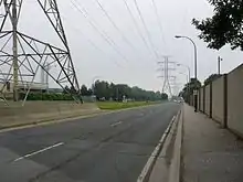
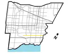
The Queensway (or Queensway) is a major street in the municipalities of Toronto and Mississauga, Ontario, Canada. It is a western continuation of Queen Street, after it crosses Roncesvalles Avenue and King Street in Toronto. The Queensway is a divided roadway from Roncevalles westerly until 600 metres of the South Kingsway (accessed by ramps) with its centre median dedicated to streetcar service. The road continues undivided west from there to Etobicoke Creek as a four- or six-lane thoroughfare.
  Queensway | |||||||
|---|---|---|---|---|---|---|---|
| Peel Regional Road 20 | |||||||
 The Queensway within Toronto | |||||||
| Route information | |||||||
| Maintained by City of Toronto Region of Peel City of Mississauga | |||||||
| Existed | 1947–present | ||||||
| Major junctions | |||||||
| West end | Glengarry Road | ||||||
| Mavis Road Hurontario Street Kipling Avenue Islington Avenue Royal York Road South Kingsway | |||||||
| East end | Roncesvalles Avenue / King Street (Continues as Queen Street) | ||||||
| Highway system | |||||||
Roads in Ontario
| |||||||
After crossing the creek, it enters Mississauga under Peel Region jurisdiction as Peel Regional Road 20, as far west as Mavis Road, with the westernmost portion to Glengarry Road being maintained by the city. There is a road allowance with hydro lines, cutting into the Mississaugua Golf & Country Club on the shores of the Credit River. In the 1990s, the name Queensway was eliminated on the roads on this allowance west of the river. The street gives its name to Etobicoke's The Queensway neighbourhood.
Name
The Queensway in Toronto was once named Queen Street and was officially the western part of the street in Old Toronto. There were three separate portions: the easternmost being a stub of the main section of Queen that continued west of Roncesvalles Avenue to Colborne Lodge Drive; a central section separated from it by a swampy area south of Grenadier Pond in High Park, running west of Ellis Avenue; and the westernmost running through the former Etobicoke west of the Humber River. The section west of the Humber was named The Queensway in 1947 to avoid confusion due to the break, but the name "Queen Street" was not restored after the present Queensway was completed to connect the sections of the formerly broken street. The most likely reason for this was because the Borough of Etobicoke desired a counterpart The Kingsway.[1] [2]
In Mississauga, the road is simply named "Queensway", with east and west designations on either side of Hurontario Street: Queensway East and Queensway West
Overhead exit signs on Highway 427 formerly showed The Queensway as "Queensway Avenue" while present signs use the proper designation. It is unclear as to why the older signs use an incorrect name, but it was likely to avoid confusion with adjacent exit signs for the parallel Queen Elizabeth Way. After provincial downloading in 1998, there was no longer any need for the Queensway Avenue signage once the eastern QEW was redesignated as the Gardiner Expressway, although that signage was still present mixed with the proper signs for a time after the downloading.[3]
From 1953 to 1954, The Queensway was signed briefly as Ontario Highway 108 when it was under the-then Department of Highways from Highway 27 (Highway 427) and the eastern end of the Queen Elizabeth Way.
History
What would become the Queensway in Mississauga was formerly the Upper Middle Road (or the 1st Concession South of Dundas Street).[4]
The section between Roncesvalles and the Humber River was built in the 1950s, in conjunction with the construction of the Gardiner Expressway. The Queensway was built before the Gardiner to provide an east–west route for traffic while Lake Shore Boulevard was rerouted to accommodate the Gardiner. The project cost $4.9 million.[5] The section from the Humber River west predates the High Park section and was previously known as Stock's Side Road, and then Queen Street. It originally spurred off Lake Shore Boulevard (then known as Lake Shore Road) at the Humber River, but that connection was severed with the building of the Queen Elizabeth Way.
To build the Parkside Drive to Ellis Drive section, the Metro government bought 18 acres (7.3 ha) of High Park from the city. This was in contravention of stipulations by original High Park owner John Howard that the lands be used for parkland only. Metro officials searched for descendants of Howard to obtain their consent.[5]
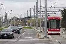
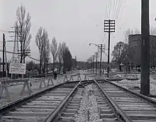
The Queensway became the new location for the streetcar line trackage along the lake shore in the area and a separate right-of-way was part of the design from Parkside Drive to the Humber. The right-of-way on the Queensway opened to streetcar service on July 21, 1957. It is the route used by the 501 Queen and the 508 Lake Shore.
During the post-2000 period, the Queensway has been subject to new condominium development, particularly in the vicinity of the Humber River. An attraction to this development is the proximity to downtown streetcar service. The streetcar right-of-way has been proposed as a future subway corridor, parallel to the existing Bloor subway line, should transit ridership increase dramatically in the future. More immediately, there has been a move to consider creation of an extended right of way streetcar system on the portion of Queensway west of the Humber Loop transit terminus, offering direct access to downtown.
The right-of-way was rebuilt, starting in the summer of 2005, after a period of prolonged deterioration. The traffic lanes were also rebuilt. The eastbound lanes were finished early in 2006, while completion of the westbound lanes was realized in early 2007.
Nearby landmarks
From east to west:
Toronto
- TTC Roncesvalles Streetcar barns
- St. Joseph's Health Centre
- High Park
- Ontario Food Terminal
- Palace Pier Park
- Humber Bay Park
- Church on the Queensway (formerly named Queensway Cathedral),[2] a Pentecostal megachurch
- Queensway Health Centre
- Sherway Gardens
Mississauga
- Mississauga Hospital
- Huron Park Recreation Centre (north off of the Queensway)
- Credit Valley Golf and Country Club
References
- "East-West Roads - The Queensway". Etobicoke Historical Society.
- "The Queensway". Etobicoke Historical Society. Retrieved 2019-09-11.
- "King's Highway 427 - Images". www.onthighways.com.
- "Dixie: Orchards to Industry. p. 28" (PDF). Hicks, Kathleen. Mississauga Library System. 2006. Retrieved December 21, 2018.
- "Award Expressway Contract Today for Queen St. Bridge Over Humber". The Globe and Mail. March 22, 1955. p. 1.
Major roads, highways and streets in Toronto | |||||||||
|---|---|---|---|---|---|---|---|---|---|
| North–south |
| ||||||||
| East–west |
| ||||||||
| |||||||||
| |||||||||