Ontario Highway 400
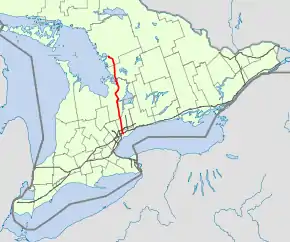
King's Highway 400, commonly referred to as Highway 400, historically as the Toronto–Barrie Highway, and colloquially as the 400, is a 400-series highway in the Canadian province of Ontario linking the city of Toronto in the urban and agricultural south of the province with the scenic and sparsely populated central and northern regions. The portion of the highway between Toronto and Lake Simcoe roughly traces the route of the Toronto Carrying-Place Trail, a historic trail between the Lower and Upper Great Lakes. North of Highway 12, in combination with Highway 69, it forms a branch of the Trans-Canada Highway (TCH), the Georgian Bay Route, and is part of the highest-capacity route from southern Ontario to the Canadian West, via a connection with the mainline of the TCH in Sudbury. The highway also serves as the primary route from Toronto to southern Georgian Bay and Muskoka, areas collectively known as cottage country. The highway is patrolled by the Ontario Provincial Police and has a speed limit of 100 km/h (62 mph), except for the section south of the 401, where the speed limit is 80 km/h (50 mph).
| ||||
|---|---|---|---|---|
| Toronto–Barrie Highway[1] | ||||
 | ||||
| Route information | ||||
| Length | 226.0 km[2] (140.4 mi) | |||
| History | Opened December 1, 1951 – July 1, 1952[3] | |||
| Major junctions | ||||
| South end | Maple Leaf Drive – Toronto (continues as Black Creek Drive) | |||
| North end | ||||
| Location | ||||
| Divisions | York Region, Simcoe County, Muskoka, Parry Sound District, Sudbury District (future) | |||
| Major cities | Toronto Vaughan Barrie Sudbury (future) | |||
| Towns | Parry Sound, Bradford, King | |||
| Highway system | ||||
| ||||

Highway 400 is the second longest freeway in the province, the trans-provincial Highway 401 being the longest. It was the first fully controlled-access highway in Ontario when it was opened between North York and Barrie on July 1, 1952. On that date, it was also the first highway to be designated as a 400-series. The freeway was extended in both directions; north of Barrie to Coldwater in 1958, and south of Highway 401 to Jane Street in 1966. It was widened between North York and Barrie in the 1970s. Since 1977, construction on the freeway has been snaking north along Highway 69 towards Parry Sound and Sudbury.
As of 2011, a four lane freeway is opened as far north as Carling; at that point, the four lanes narrow into two and continue northerly to Sudbury as Highway 69. At the north end of Highway 69, a segment of freeway is in operation between north of the French River and Sudbury; while this section will be part of the completed Highway 400 route, at present it remains signed as Highway 69. The remaining gap between Carling and north of the French River will be opened in stages as construction is undertaken and completed.[4]
Route description
While Highway 400 was originally known as the Toronto–Barrie Highway, the route has been extended well beyond Barrie to north of Parry Sound, and is projected to reach its eventual terminus in Sudbury in the 2020s.[5] As of 2009, the length of the highway is 209.0 km (129.9 mi) with an additional 152 km (94 mi) planned.[6]
Highway 400 begins at the Maple Leaf Drive overpass in Toronto, south of Highway 401.[2] South of that, it is known as Black Creek Drive, a high speed commuter road once planned as a southern extension of Highway 400. Highway 400 had been completed to Jane Street in 1966 (alongside the expansion of Highway 401) but plans to extend Highway 400 further south to the Gardiner Expressway were cancelled after several citizens groups protested the proposal in the 1970s. Black Creek Drive was built along the empty right-of-way and transferred to Metro Toronto in 1982.[7]
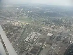
North of Maple Leaf Drive, the highway shifts northwestward, but then turns approximately northward at Highway 401. At the interchange with the 401, Highway 400 widens to twelve lanes. It continues north, losing two lanes at Finch Avenue.[8] The section between Highway 407 and Langstaff Road in suburban Vaughan features a short collector-express system.[9] The 400/407 junction is the only four-level stack interchange in Canada.[9]
From Highway 401 to the Holland Marsh the freeway largely parallels the arterial/concession roads Weston Road and Jane Street, passing over the height of land at the Oak Ridges Moraine.[9] The highway passes through protected rural areas in northern York Region and encounters rolling countryside in Simcoe County south of Barrie.[8] The section near Barrie is subject to snowsqualls as it lies near the edge of Georgian Bay's snowbelt.
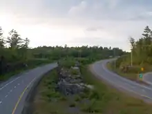
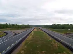
Within Barrie, Highway 400 passes through a trench which places it below grade for most of its length,[8] the route curving around downtown Barrie towards the north-east.[9] On the outskirts of Barrie, the through right-of-way continues as Highway 11 towards Orillia and North Bay, while Highway 400 exits and veers 90 degrees to the north-west towards Georgian Bay, travelling alongside the former Highway 93 to Craighurst.[10] At Craighurst the highway again turns north-east, skirting the Copeland Forest and the ski hills of the Oro Moraine, to meet Highway 12, which runs concurrently with the 400 between Exits 141 and 147, in Coldwater.[10] From here, the highway takes on the Trans-Canada Highway designation, and follows a predominantly north-western heading along what was the route of Highway 69, toward the planned terminus of Sudbury.[11] In Muskoka and Parry Sound Districts, Highway 400 is in most sections a twinned four-lane highway,[8] but several bypasses have and are being built to circumvent the communities along the way.[11][12] At Port Severn, the highway meets the rugged Canadian Shield, and winds its way north through the granite, often flanked by towering slabs of rock.[8]
History
Initial construction
Highway 400, along with Highway 401 and Highway 402, was one of the first modern freeways in Ontario. Planning for the Toronto–Barrie Highway, which would become Highway 400, began in 1944.[1] The two routes connecting Barrie with Toronto at the time, Highway 11 and Highway 27, were becoming congested. Grading on a new alignment between Weston Road and Jane Street was completed from Wilson Avenue to Highway 27 (Essa Road) by 1947.[3] The onset of the Korean War slowed construction on the highway considerably,[13] and it wasn't until December 1, 1951 that two lanes (one in each direction) would be opened to traffic. All four lanes were opened to traffic on July 1, 1952, at which point the highway was designated Highway 400.[14] The name was the scorn of one newspaper editor, who published his distaste for using numbers to name a highway.[15] The freeway featured a 9.1 m (30 ft) grass median.[16]
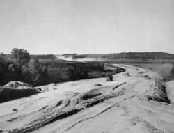
Shortly after its completion, Hurricane Hazel struck on October 15, 1954. The torrential downpours caused catastrophic damage to southern Ontario, amongst which was the flooding of Holland Marsh to a depth of 3.3 m (11 ft). Several bridges and sections of road were washed away by Hazel. The damaged highway and bridges were completely reconstructed after the water was pumped away.[3]
Expansion
By 1958 Highway 400 was extended north parallel with Highway 93 as a super two with at-grade intersections to Craighurst and construction had begun to extend it further to Highway 12 and Highway 103 at Coldwater.[17] Both sections opened to traffic on December 24, 1959.[18] For many years afterwards, and still today to older drivers, this portion of the 400 north of Barrie is referred to as the "400 Extension".
The cloverleaf interchange with Highway 401 that was completed in 1953 was replaced by a semi-directional three-level junction in the mid-1960s, as part of Highway 401's expansion to a collector-express system. As part of that reconstruction project, Highway 401's direct access to Jane Street was removed in favor of a new interchange at Highway 400's then-southern terminus.[19]
Plans were also conceived to extend the freeway south from Highway 401 to Eglinton Avenue, where it would join two new expressways: the Richview and the Crosstown Expressways.[20] These plans would never reach fruition, as public opposition to urban expressways cancelled most highway construction in Toronto by 1971.[21] Highway 400 would still open as far south as Jane Street on October 28, 1966 before the rest of the plans were shelved following the cancellation of the Spadina Expressway.[22] The province used the right-of-way in the Black Creek valley to construct a four-lane divided expressway with signalled intersections as far south as Eglinton Avenue. Originally known as the Northwest Arterial Road, the expressway was transferred to Metropolitan Toronto on March 1, 1983 and named Black Creek Drive. In exchange, the province was given the expropriated land purchased for Spadina south of Eglinton Avenue.[23]
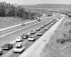
Widening of Highway 400 began in 1971. An additional lane in either direction was created by reducing the 9.1 m median by 6 m (20 ft) and using 1.2 m (4 ft) of the shoulder on each side. The first section to be widened was from Highway 401 to Finch Avenue, which was widened to eight lanes. Soon thereafter, the section from Finch to Highway 88 was widened to six lanes. A year later, the six lane freeway was extended 41.8 km (26 mi) north to Highway 11.[16]
The two-lane highway north of Barrie was widened starting in 1977, necessitated by the increasing use of the highway by recreational tourists and vacationers. This work involved the construction of two southbound lanes parallel to the original, with a 30 metres (98 ft) median between them. In addition, at-grade intersections were converted into grade-separated interchanges. This work was completed as far as Highway 93 north of Craighurst by 1982. In 1980 construction began on four-laning the section from Highway 93 to Simcoe County Road 19,[24] which was completed by the end of 1982. During the summer of 1983, four-laning began between Simcoe County Roads 19 and 23, bypassing west of Coldwater. This was completed during the summer of 1985.[25]
Between 1985 and 1987, the pace of construction slowed temporarily as the foundations for a new southbound structure over Matchedash Bay on Highway 69 just north of Highway 12 were compacted and settled. During the fall of 1987, a contract was awarded to extend the four-laning north to Waubaushene and to complete the interchange with Highway 12, first constructed during the late 1950s with the two-lane highway.[26] This work was completed a year later during the fall of 1988.[27]
Starting in the late 1980s to the early 2000s, Highway 400 was expanded and upgraded in suburban Vaughan. The cloverleaf interchange with Highway 7 was reconstructed as a Parclo A4 in 1987-88.[28] Between Steeles Avenue and Highway 7 the northbound lanes of Highway 400 was shifted to a temporary diversion until 1992, bypassing the original alignment in order to facilitate construction of the four-level stack interchange with the upcoming Highway 407, portions of this bypass were later retained for the ramps to and from Highway 407.[29][30] A collector-express system was added shortly afterwards to separate incoming/outgoing Highway 407 traffic from access to Highway 7 and Langstaff Road.[9][9] The junctions at Rutherford Road and Major Mackenzie Drive (2003-04) were also reconstructed as Parclo A4 interchanges.[31]
Twinning Highway 69
North of Highway 12, Highway 400 transitioned into the two-lane Highway 69. Several structures were constructed over the next few years in preparation for twinning Highway 69. In 1988 construction began on the southbound structures over Matchedash Bay and the Canadian National Railway crossing north of Highway 12.[32] Both were complete by the end of 1990. During 1991, construction began on the interchanges at Quarry Road and Port Severn Road, new service roads between those interchanges and the southbound structure over the Trent–Severn Waterway.[27][33]
Following the twinning of Highway 69 (which was not redesignated as Highway 400 until 1997, several years after completion) to Port Severn, the next target became Parry Sound. In 1988, the Ministry of Transportation of Ontario completed a study of the Highway 69 corridor between Muskoka Road 5 in Port Severn and Tower Road southwest of MacTier, a distance of approximately 45 km (28 mi). This work was carried out through the 1990s, reaching as far as Muskoka Road 38 (former Highway 660) by 1999.[34][35] The four-laning was extended north to the Musquash River in October 1999, although an interchange wasn't constructed at Muskoka Road 32/38 until October 2005.[11][36] However, a land claim dispute between the Government of Ontario and the Wahta Mohawk Territory prevented the twinning of the highway between the Musquash and Moon Rivers. The Territorial Reserve did not oppose the construction; however, the land was unobtainable due to a technicality requiring a minimum voter turnout of 65 percent.[37]
Construction of the Parry Sound Bypass, a new alignment from Badger Road to the Seguin River, began with an interchange along Highway 518 at the site of the future freeway, which was completed during the autumn of 1999.[38] Construction south of the interchange to Badger Road started in November 1999, while the section north of the interchange to the Seguin River began three months later.[39]
On February 7, 2000, the government officially committed to complete Highway 400 to Parry Sound.[40] Work began on two projects as a result of this: a 26.5 km (16.5 mi) bypass of Highway 69 on a new alignment between the Moon River, south of MacTier, and Rankin Lake Road near Horseshoe Lake, as well as a 4 km (2.5 mi) segment connecting that to the Parry Sound Bypass.[41]
The first segment of freeway to be completed north of the Musquash River was the Parry Sound Bypass, which opened on November 1, 2001.[42] This section bypassed to the east of the old highway, now known as Oastler Park Drive.[10] However, it was numbered as Highway 69 for the moment. In October 2002, the section south of the Parry Sound Bypass to Rankin Lake Road was opened.[42] This was followed a year later on October 7 with the opening of the bypass of Highway 69 from the Moon River to Rankin Lake Road, connecting with the Parry Sound segment. At that point, the Highway 400 designation was extended north to the Seguin River. However, the Highway 69 designation remained in place as far south as the Musquash River.[43]
The remaining 8 km (5.0 mi) gap through the Wahta Mohawk Territory would eventually be constructed, starting in December 2004.[44] It opened to traffic during the summer of 2008,[45] completing the freeway south of Parry Sound. Since then, the Highway 69 designation has been removed south of Nobel.[2]
Since 2000
In the early 2000s, the junctions with Rutherford Road and Major Mackenzie Drive in Vaughan were extensively reconstructed to modern Parclo A4 configurations, and a new partial interchange was added for Bass Pro Mills Drive in 2004 to accommodate the opening of the Vaughan Mills shopping centre.
On October 27, 2010, one lane in either direction on the Nobel Bypass opened to traffic. The new four-lane bypass, which travels as far north as Highway 559, was fully opened in November. The former route of Highway 69 through the town was renamed as Nobel Drive and was reduced in width from four to two lanes, with a recreational trail constructed alongside the road.[46] Some businesses in Nobel were affected after the opening of the new highway 400 realignment and had to be closed down.[47][48][49]
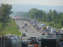
On February 27, 2014, a major snowsquall affected Highway 400 in Innisfil with heavy wind gusts and near-zero visibility. A total of 96 vehicles were involved in a major collision that ensued near Innisfil Beach Road. Although no injuries were reported, the highway was closed for a day and buses were shuttled in to warm stranded motorists.[50]
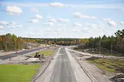
On June 28, 2005, it was officially confirmed that Highway 69 would be twinned and bypassed north to Highway 17 in Sudbury. This announcement was accompanied by a time line with the completion date set for 2017;[51] in March 2015, the Ministry of Transportation acknowledged that the original completion date will not be met, and announced that its current goal is to have the project completed in the 2020s.[4] However, work was already underway in 2003 to expand Highway 69 south of Sudbury to four lanes.[52] As work is completed at the southern end near Nobel, the Highway 400 designation is being extended north.[5]
Construction began on the segment from Sudbury southwards to Estaire in 2005,[53] while route planning studies were completed for the Estaire to Parry Sound segment. Portions of the route will be opened to traffic in segments as contracts are fulfilled; the segment between Sudbury and Estaire opened on November 12, 2009,[53][54] while the Nobel bypass from Parry Sound to Highway 559 opened October 26, 2010.[46] As the Sudbury segment of the Highway 69 freeway is discontinuous with Highway 400, it will not be renumbered until the twinning of the intervening section is completed.[42]
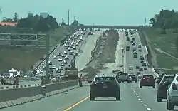
As one of the oldest 400-series freeways, several vintage overpasses have been demolished in recent years to accommodate the future expansion of Highway 400 to ten lanes in the section from Vaughan to Barrie. Sixteen of these historic structures, sub-standard by today's freeway requirements, remained as of summer 2009, with all slated for replacement in the near future. In order to preserve some of this heritage the Ministry of Transportation created an 1800mm x 1625mm reusable urethane mould of the provincial coat-of-arms from the 5th Line overpass located south of Bradford, which will be used to decorate the replacement structures.[55]
Construction began north of Barrie in April 2013 to replace the overpass at the Crown Hill junction with Highway 11.[56] The new structure, designed to accommodate future highway expansion, was completed in October 2015. The original overpass, built during the 1950s, was demolished during an overnight closure on December 13, 2015. The overall cost of this project was C$8.5 million.[57][58]
Services
There are four service centres located along the southern section of Highway 400: Maple, King City, Innisfil and Barrie.[59] The centres were originally leased to and operated by several major gasoline distributors; however, those companies chose not to renew their leases as the terms end. In response, the MTO put the operation of the full network of service centres out for tender, resulting in a 50-year lease with Host Kilmer Service Centres, a joint venture between hospitality company HMSHost (a subsidiary of Autogrill) and Larry Tanenbaum's investment company Kilmer van Nostrand, which operates them under the ONroute brand.[60]
Three of the four service centres were upgraded and feature a Canadian Tire gas station, an HMSHost-operated convenience store known as "The Market", as well as fast food brands such as Tim Hortons, A&W and Burger King. The southbound Vaughan service centre, a newer centre which was already more modern than the others, was not included in these plans.[61] The Barrie centre closed for reconstruction on October 19, 2010. The King City service centre relocated a few hundred meters south in October 2012. The Cookstown centre had its redevelopment underway on February 1, 2013 and reopened in June 2015, however it moved to a new location (the original being located at the Highway 89 interchange and incorporated into the southbound ramp, but accessible to northbound traffic by exiting on westbound Highway 89 then turning at a driveway on the west side of the 400) north of Fourth Line and rebranded as Innisfil ONRoute.[62] Service centres are located at the following points along Highway 400:
| Location | Name | Nearby exits[10] |
Direction | Status[62] |
|---|---|---|---|---|
| Vaughan | Maple | 37 | Southbound | Will not be redeveloped at this time. Leased by Imperial Oil. |
| King | King City | 43 | Northbound | Reopened October 2012 |
| Innisfil | Innisfil | 75 | Southbound | Reopened June 2015 |
| Barrie | Barrie | 94 | Northbound | Reopened August 2013 |
North of Barrie, where average traffic volumes do not warrant large service centres with direct highway access, there are two additional service campuses, located on crossroads at interchanges in Port Severn (Exit 156) and at Seguin Trail (Exit 214) near Parry Sound, operated by Petro Canada.
Exit list
The following table lists the major junctions along Highway 400, as noted by the Ministry of Transportation of Ontario.[2]
| Division | Location | km[2] | mi | Exit | Destinations | Notes | |
|---|---|---|---|---|---|---|---|
| Toronto | 0.4 | 0.25 | 20 | Jane Street | |||
| 1.6 | 0.99 | 21 | Signed as exits 21A (east) and 21B (west) | ||||
| 1.8 | 1.1 | 23 | Wilson Avenue | Access to Wilson was removed during the reconstruction of the interchange with Highway 401 | |||
| 6.0 | 3.7 | 25 | Finch Avenue | ||||
| 8.1 | 5.0 | 27 | Steeles Avenue | Northbound exit and southbound entrance | |||
| York | Vaughan | ||||||
| 9.3 | 5.8 | 28 | Tolled; southbound access via express lanes only. Northbound on ramp to express lanes. | ||||
| 10.2 | 6.3 | 29 | Formerly | ||||
| 12.2 | 7.6 | 31[63] | Northbound exit and southbound entrance misidentified as Exit 30 on some maps[10] No access to and from Highway 407. | ||||
| 32 | Bass Pro Mills Drive | Northbound exit and southbound entrance, access to Vaughan Mills mall opened November 2004. | |||||
| 14.3 | 8.9 | 33 | Northbound exit and southbound entrance opened in May 1981 to accommodate the opening of Canada's Wonderland.[64] Later fully reconstructed into a full interchange in 1993. | ||||
| 16.4 | 10.2 | 35 | |||||
| 18.5 | 11.5 | 37 | Opened September 18, 2009[65] | ||||
| 19.7– 21.8 | 12.2– 13.5 | Maple Service Centres | |||||
| King | 24.8 | 15.4 | 43 | ||||
| 34.0 | 21.1 | 52 | |||||
| 37.2 | 23.1 | 55 | Highway 9 formerly continued east of interchange | ||||
| Simcoe | Bradford West Gwillimbury | 58 | Canal Road | Right-in/right-out interchange; will eventually be removed, redundant since opening of Line 5 interchange | |||
| 61 | Opened December 19, 2018[66] | ||||||
| 45.7 | 28.4 | 64 | Formerly | ||||
| Innisfil | 57.1 | 35.5 | 75 | Highway 89 formerly continued east of interchange; former location of Cookstown Service Centre (southbound, access incorporated into ramps) | |||
| 62.3 | 38.7 | Innisfil Service Centre (Southbound) | |||||
| 66.8 | 41.5 | 85 | |||||
| Barrie | 71.8 | 44.6 | 90 | Mapleview Drive | Formerly Molson Park Drive | ||
| 73.6 | 45.7 | Barrie Service Centre (Northbound) | |||||
| 75.6 | 47.0 | 94 | Essa Road | Formerly | |||
| 78.0 | 48.5 | 96 | Dunlop Street – Angus | Signed as exits 96A (east) and 96B (west) northbound; formerly | |||
| 80.4 | 50.0 | 98 | Formerly | ||||
| 83.1 | 51.6 | 102 | Duckworth Street | ||||
| Simcoe | Springwater | 85.8 | 53.3 | — | Northbound left exit (default flow) and southbound left entrance (default flow); signed as Highway 11 northbound, Highway 400 southbound | ||
| 92.4 | 57.4 | 111 | |||||
| 98.7 | 61.3 | 117 | |||||
| Oro-Medonte | 102.2 | 63.5 | 121 | Highway 93 formerly continued south of interchange | |||
| 112.6 | 70.0 | 131 | Mount St. Louis Road | Exit for Mount St. Louis Moonstone Ski area | |||
| 117.5 | 73.0 | 136 | |||||
| 120.1 | 74.6 | 137 | Lower Big Chute Road – Coldwater | Northbound exit and southbound entrance | |||
| Severn | 122.9 | 76.4 | 141 | Southern end of Highway 12 concurrency | |||
| 128.8 | 80.0 | 147 | Northern end of Highway 12 concurrency | ||||
| 131.1 | 81.5 | 149 | Quarry Road | Formerly County Road 59 | |||
| 135.1 | 83.9 | 153 | Port Severn Road South – Port Severn | ||||
| Muskoka | Georgian Bay | 137.2 | 85.3 | 156 | District Road 5 (Muskoka Road / Port Severn Road North) – Port Severn, Honey Harbour | Location of Petro Canada service campus | |
| 143.5 | 89.2 | 162 | District Road 34 (White's Falls Road) District Road 48 (South Bay Road) – Severn Falls | ||||
| 148.8 | 92.5 | — | Hidden Glen Road | Southbound Right-in/right-out interchange | |||
| 150.8 | 93.7 | 168 | Georgian Bay Road, Crooked Bay Road | ||||
| 174 | District Road 33 (South Gibson Lake Road) | ||||||
| 175.1 | 108.8 | — | Global Tower Road | Southbound Right-in/right-out interchange for access to CIII-DT-7/CHCH-DT-3 tower site | |||
| Wahta Mohawk Territory | 162.3 | 100.8 | 177 | District Road 32 (Go Home Lake Road) District Road 38 – Bala | |||
| 182 | Iroquois Cranberry Growers Drive | ||||||
| Georgian Bay | 185 | District Road 12 (12 Mile Bay Road) | |||||
| 171.1 | 106.3 | 189 | Lake Joseph Road (MacTier, Gravenhurst) | Formerly Highway 69 | |||
| Parry Sound | Seguin | 189.6 | 117.8 | 207 | |||
| 195.5 | 121.5 | 213 | Rankin Lake Road | ||||
| 198.6 | 123.4 | 214 | Seguin Trail, Horseshoe Lake Road | Location of Petro Canada service campus | |||
| 201.8 | 125.4 | 217 | Oastler Park Drive, Badger Road | ||||
| 205.2 | 127.5 | 220 | |||||
| Parry Sound | 208.8 | 129.7 | 224 | Bowes Street, McDougall Road | |||
| 211.3 | 131.3 | 229 | Parry Sound Drive | ||||
| McDougall | 213.9 | 132.9 | 231 | ||||
| 219.0 | 136.1 | 237 | Avro Arrow Road — Nobel | ||||
| 224.4 | 139.4 | 241 | |||||
| Carling | 225.7 | 140.2 | |||||
| Woods Road | |||||||
| The Archipelago | Shebeshekong Road (Highway 7182) | ||||||
| Unorganized Parry Sound | Harris Lake Road | ||||||
| Specific alignment under review | |||||||
| Specific alignment under review | |||||||
| Pickerel River Road / Settlers Road | |||||||
| Sudbury | Killarney | ||||||
| Interchange opened in July 2016. Twinned highway continues south to a point on the route approximately 5 km north of the French River.[67][68] | |||||||
| Unorganized Sudbury | Crooked Lake Road | Delamere access road. Interchange opened in September 2015. | |||||
| Interchange opened in October 2012. | |||||||
| Nelson Road | Access to town of Estaire. Interchange opened in November 2009. | ||||||
| Greater Sudbury | Interchange opened in November 2009. | ||||||
| Estaire Road | |||||||
| Final phase to link to twinned Southeast Bypass | |||||||
1.000 mi = 1.609 km; 1.000 km = 0.621 mi
| |||||||
References
- "Toronto–Barrie Highway". The Maple Leaf. October 2, 1944. Retrieved June 23, 2015.
- Ministry of Transportation of Ontario (2008). "Annual Average Daily Traffic (AADT) counts". Government of Ontario. Archived from the original on July 6, 2011. Retrieved December 27, 2011.
- Shragge 1984, pp. 89–92.
- Carmichael, Harold (March 7, 2015). "Highway 69 to be delayed, province admits". Sudbury Star. Retrieved August 7, 2016.
- Ross, Ian (July 13, 2008). "Highway 69 and 11 Expansion Rolling North". Northern Ontario Business. Retrieved June 2, 2010.
- Ministry of Transportation of Ontario. "Quick Facts". Government of Ontario. Archived from the original on April 21, 2011. Retrieved March 22, 2010.
- Best, Michael (March 13, 1986). "Lastman Gathering Ammunition in Battle to Complete Spadina". Torstar Corp. p. A6. Archived from the original on April 23, 2011. Retrieved July 1, 2010.
- Google (February 17, 2014). "Highway 400 - length and Route" (Map). Google Maps. Google. Retrieved February 17, 2014.
- MapArt (2011). Golden Horseshoe (Map). Peter Heiler Ltd. pp. 102, 108, 336, 342, 348, 354, 502, 505, 508. ISBN 978-1-55198-213-7.
- Ontario Back Road Atlas (Map). Cartography by MapArt. Peter Heiler. 2010. p. 24, 30, 41, 56–57. § Q26–K31. ISBN 978-1-55198-226-7.
- Ministry of Transportation of Ontario (May 2000). "Highway 69 Four-Laning Port Severn to Parry Sound" (PDF). Government of Ontario. Retrieved December 27, 2011.
- Ministry of Transportation of Ontario (July 2009). "Highway 69 Four-Laning Parry Sound to Sudbury" (PDF). Government of Ontario. Archived from the original (PDF) on June 8, 2011. Retrieved December 27, 2011.
- Shragge, John G. (2007). "Highway 401 - The Story". Archived from the original on March 28, 2008. Retrieved February 12, 2010.
- Shragge 1984, pp. 89.
- Woodsworth, Charles J. (October 17, 1952). "Tasteless Names For Ontario Roads". 110 (93). Ottawa: The Evening Citizen. p. 40. Retrieved February 9, 2010.
- Shragge 1984, p. 91.
- Annual Report for the Fiscal Year. Ontario Department of Highways. March 31, 1959. p. 28. Retrieved July 20, 2010.
- "Open 400 Link to Coldwater". The Toronto Star. December 24, 1959. p. 18.
The new, 22-mile extension from south of Crown Hill to Coldwater will be ready for traffic this afternoon.
- Don Valley Parkway Extension, Highway 401 to Steeles Avenue (Report). Desjardines. 1957.
- Sewell, John (1993). The Shape of the City: Toronto Struggles with Modern Planning. University of Toronto Press. ISBN 0-8020-7409-X.
- Shragge 1984, pp. 89–91.
- Stein, David (February 26, 1983). "End of the Spadina Saga?". The Toronto Star. p. B5.
- "Highway 400 - North of Barrie". Provincial Highways Construction Projects 1982-83 (Report). Ministry of Transportation and Communications. April 1982. p. XXII.
- "Highway 400 & 69: Coldwater to Port Severn". Provincial Highways Construction Projects 1985-86 (Report). Ministry of Transportation and Communications. April 1985. p. XVII. ISSN 0714-1149.
- "Highway 400 & 69: From Coldwater to Port Severn". Provincial Highways Construction Projects 1988-89 (Report). Ministry of Transportation. April 1988. p. XVII. ISSN 0714-1149.
- "Highway 400 & 6:9 From Coldwater to Port Severn". Provincial Highways Construction Projects 1989-90 (Report). Ministry of Transportation. May 1989. p. 14. ISSN 0714-1149.
- Bevers, Cameron. "Photographic History of King's Highway 400 - Images". www.onthighways.com.
- "Highway 400 & 69: From Coldwater to Port Severn". Provincial Highways Construction Projects 1991-92 (Report). Ministry of Transportation. May 1991. p. 10. ISSN 0714-1149.
- Cartography Section (1990–91). Ontario Road Map (Map). Ministry of Transportation. § F–K8.
- Geomatics Office (1999). Ontario Road Map (Map). Ministry of Transportation. § O–Q25.
- Ministry of Transportation of Ontario (June 2006). "Status of Construction Activity". Government of Ontario. Archived from the original on October 3, 2006. Retrieved December 27, 2011.
- Ladan, Mark (February 20, 2002). "Land Claim Issues Leave Highway 400 Extension in Limbo". Government of Ontario. Archived from the original on May 12, 2012. Retrieved December 27, 2011.
- Ministry of Transportation of Ontario (2000). "Status of Construction Activity". Government of Ontario. Archived from the original on August 23, 2000. Retrieved December 27, 2011.
- Ministry of Transportation of Ontario (2000). "Frequently Asked Questions". Government of Ontario. Archived from the original on January 18, 2001. Retrieved December 27, 2011.
- Ministry of Transportation of Ontario (2001). "Status of Construction Activity". Government of Ontario. Archived from the original on December 27, 2001. Retrieved December 27, 2011.
- Ministry of Transportation of Ontario (November 21, 2002). "Status of Construction Activity". Government of Ontario. Archived from the original on December 4, 2002. Retrieved December 27, 2011.
- Ministry of Transportation of Ontario (2002). "Limits of Existing Four Laning". Government of Ontario. Archived from the original on February 15, 2003. Retrieved December 27, 2011.
- Ministry of Transportation of Ontario (October 7, 2003). "Notice of Opening of a New Four-Lane Highway Section of Highway 400". Government of Ontario. Archived from the original on December 27, 2003. Retrieved December 27, 2011.
- Ministry of Transportation of Ontario. "Status of Construction Activity". Government of Ontario. Archived from the original on April 7, 2010. Retrieved December 27, 2011.
- Ministry of Transportation of Ontario (2009). "Status of Construction Activity". Government of Ontario. Archived from the original on April 7, 2010. Retrieved December 27, 2011.
- Ginn, Cameron (October 27, 2010). "$177-Million Section of Highway Now Open". Cottage Country Now. Metroland Media Group. Archived from the original on April 24, 2011. Retrieved October 28, 2010.
- Ginn, Cameron (November 19, 2011). "Nobel Complex Victim of New Highway 400". Cottage Country Now. Metroland Media Group. Archived from the original on March 12, 2012. Retrieved December 27, 2011.
- "Tim Horton's and Wendy's in Nobel Closed". Parry Sound: moosefm.com/CKLP-FM. January 7, 2011. Archived from the original on July 24, 2011. Retrieved December 27, 2011.
- Robson, Dan (December 3, 2010). "Highway 69 Construction Could Prove Fatal to Roadside Businesses". The Toronto Star. Retrieved December 27, 2011.
- Criger, Erin (February 27, 2014). "Hwy. 400 reopens in Innisfil after massive pileup". CityNews. Retrieved February 28, 2014.,
- Staff (August 1, 2005). "Highway 69 Plan Released: Highway to be Four-Laned from Sudbury to Toronto by 2016". Northern Ontario Business. Laurentian Media Group. Retrieved July 21, 2010.
- "Government of Canada and Government of Ontario announce $336 million in highway improvement funding". Transport Canada. November 21, 2003. No. H138/03. Archived from the original on April 27, 2011. Retrieved August 7, 2016.
- Sudbury Northern Life Staff (November 13, 2009). "New Section of 69 Opens to Public". Northern Life. Retrieved November 3, 2011.
- Ministry of Transportation of Ontario (2009). "Status of Construction Activity". Government of Ontario. Archived from the original on August 23, 2000. Retrieved March 22, 2010.
- Ministry of Transportation of Ontario (2009). "Road Talk". 15 (3). Government of Ontario. Archived from the original on January 14, 2012. Retrieved December 27, 2011. Cite journal requires
|journal=(help) - McInroy, Ian (December 8, 2014). "Massive Hwy. 400/Hwy. 11 Split Project Reaches Milestone". The Barrie Examiner. Archived from the original on June 11, 2016. Retrieved May 18, 2016.
- Staff (December 13, 2015). "Highway 11 Reopens After Overnight Bridge Removal". CTV Barrie. Retrieved May 18, 2016.
- McInroy, Ian (December 10, 2015). "Highway 400/11 Split Bridge is Coming Down". The Barrie Examiner. Archived from the original on August 10, 2016. Retrieved May 18, 2016.
- Ministry of Transportation of Ontario (September 7, 2011). "Highway Service Centres: Current Status" (PDF). Government of Ontario. Retrieved December 27, 2011.
- "HMSHost Corporation and Kilmer Van Nostrand Co. Limited Ink 50-Year Agreement to Build 23 World-Class Service Centres on Major Canadian Highways". CNW Group. April 7, 2010. Retrieved June 5, 2010.
- "Ontario Finalizes Plans For Highway Service Centres". Brockville: Brock News. April 7, 2010. Archived from the original on July 6, 2011. Retrieved April 9, 2010.
- Ministry of Transportation of Ontario (September 7, 2011). "Ontario's New ONroute Highway Service Centres: Construction Schedule". Government of Ontario. Archived from the original on July 6, 2011. Retrieved December 27, 2011.
- Google (October 15, 2013). "Exit 31 on Highway 400" (Map). Google Maps. Google. Retrieved October 15, 2013.
- "Ontario Highway 400 Photographs - Page 2 - History of Ontario's Kings Highways". www.thekingshighway.ca. Retrieved 10 April 2018.
- "Official Opening of Teston Road Reconstruction and Highway 400 Interchange" (PDF). Regional Municipality of York. September 17, 2009. Archived from the original (PDF) on March 25, 2012. Retrieved December 27, 2011.
- "Line 5-Highway 400 interchange in Bradford opens without fanfare". Barrie Today.
- Highway 69 Four Laning (PDF) (Map). Ontario Ministry of Transportation. July 2016. Retrieved August 1, 2016.
- Distance measurements take from Google Maps satellite view accessed August 1, 2016.
- Bibliography
External links
| Wikimedia Commons has media related to Ontario Highway 400. |
- Highway 400 Live Traffic Cams
- Highway 400 extension Route Planning Studies
- Highway 400 at OntHighways.com
| Preceded by |
Trans-Canada Highway |
Succeeded by |
| British Columbia | ||
|---|---|---|
| Alberta | ||
| Saskatchewan | ||
| Manitoba | ||
| Ontario | ||
| Quebec | ||
| New Brunswick | ||
| Prince Edward Island | ||
| Nova Scotia | ||
| Newfoundland | ||
| ||

