Timeline of first images of Earth from space
This is a timeline of first images of Earth from space. The initial photographs and digital images of planet Earth taken from outer space were preceded by aerial photography and continue in the form of satellite imagery.[1][2][3][4][5][6][7][8][9][10][11][12][13][14][15][16]
For the purpose of this list, a spaceflight is defined as any flight that crosses the Kármán line, the FAI-recognized edge of space, which is 100 kilometres (62 miles) above mean sea level (AMSL).
Milestones in Earth imaging
- October 1946 - V-2: first image of Earth from outer space, taken by the V-2 No. 13 suborbital spaceflight.
October 1946 - V-2
- 1959 - Explorer 6: first image of Earth from orbit, showing a sunlit area of the Central Pacific Ocean and its cloud cover.
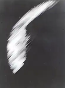
1959 - Explorer 6
- 1959 - Vanguard 2: first attempt of a scanner, in which a single photocell mounted at the focus of telescope would scan Earth due to the satellite movement; resulting images were poor.
- 1959 - Explorer 7 (launched on October 13, 1959): the first "coarse maps of the solar radiation reflected by the Earth and the infrared radiation emitted by the Earth".[17]
- 1960 - TIROS-1: first live television image of Earth from space and first weather satellite picture.[18]
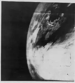
1960 - TIROS-1
- 1960 - Corona: "first space-based earth observation system";[19] its first successful mission was Discoverer 14 on 1960-08-19 with the recovery of photographic film from an orbiting satellite.[20]
- 1963 - KH-7 Gambit: first high-resolution (sub-meter spatial resolution) satellite photography (classified).
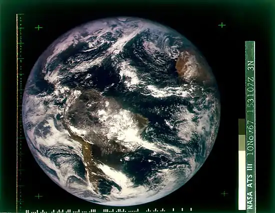
- 1966 - ATS-1: first full-disk pictures of the Earth from a geostationary orbit, on December 11, 1966.[22]
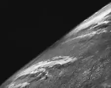
- 1966 - Lunar Orbiter 1: first image of Earth from the Moon's orbit.[23]

1966 - Lunar Orbiter 1
- 1967 - Surveyor 3: first image of Earth from the Moon's surface.[24]
- 1967 - DODGE: first full-disk color pictures of the Earth.
.png.webp)
1967 - DODGE
- 1967 - ATS-3: another claim for first full-disk color pictures of the Earth; subsequently used on the cover of the first Whole Earth Catalog.
1967 - ATS-3
- 1968 - Apollo 8: first image of Earth from space taken by a human, probably by astronaut William Anders.[25]
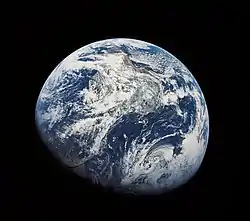
1968 - Apollo 8
- 1968 - Earthrise: first color image of Earth from the Moon, Earthrise, also by Apollo 8 astronaut William Anders.
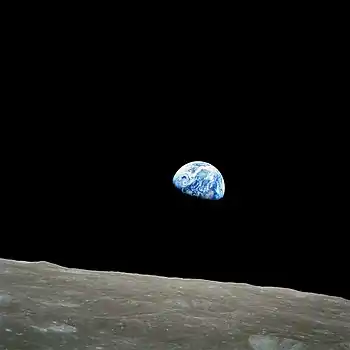
1968 - Earthrise
- 1977 - KH-11: first real-time satellite imagery.
- 1999 - IKONOS: first commercial high-resolution (sub-meter) satellite photography (non-classified); it made the cover of the New York Times on October 13, 1999.
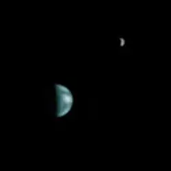
- 2020 - Solar Orbiter: first family portrait of three rocky planets (Earth, Venus, Mars) by the Solar Orbiter spacecraft.[26]
Other notable instances (non-firsts)
- 1972: the widely used The Blue Marble was taken by the crew of Apollo 17.
.jpg.webp)
AS17-148-22727, from which The Blue Marble was cropped. The photograph's original orientation had south pointed up.[27]
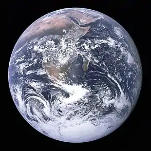
The Blue Marble, Apollo 17
- 1990: the Voyager 1 space probe took the Pale Blue Dot photograph of Earth from a record distance of about 6 billion kilometers (3.7 billion miles, 40.5 AU), as part of that day's Family Portrait series of images of the Solar System.
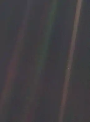
Pale Blue Dot: Earth appears as a tiny dot within deep space: the blueish-white speck almost halfway up the brown band on the right.

Diagram of the Family Portrait showing the planets' orbits and the relative position of Voyager 1 when the mosaic was captured.
- 2001-2004: Blue Marble Next Generation
Blue Marble composite images generated by NASA in 2001 and 2002.
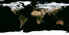
NASA Earth Observatory animation of Blue Marble Next Generation (2004); see also interactive map of monthly snapshots)
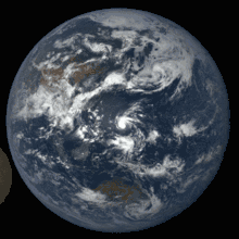
- 2010: The Cupola is installed at the ISS and provides since a wealth of intricate images of Earth from orbit.

Cupola above the darkened Earth
- 2013: The Day the Earth Smiled – July 2013 event
- 2015: launch of Deep Space Climate Observatory (DSCOVR)
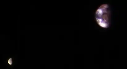
The Moon moving in front of Earth in July 2016. The far side of the Moon faces the camera.

See also
- Earth observation
- Artificial structures visible from space
- Earth phase – Phases of the Earth as seen from the Moon
- First light (astronomy) – term in astronomy for the first time a telescope is used to look at the Universe
- List of Earth observation satellites – Wikipedia list article
- Pale Orange Dot, a NASA digital model showing a possible early Earth
- Overview effect
References
- First Photo From Space
- The First Image of Earth Taken From Space (It's Not What You Think)
- Milestones in Space Photography
- First photo of Earth from space was from deadly rocket
- Explorer 6: 60 years since first Earth photo from space
- First Pictures of Earth From 100 Miles in Space, 1947
- First image of Earth from the surface of the Moon: Surveyor 3
- 60 years ago first satellite image of Earth
- 70 years ago the first image of Earth was taken from space
- The First Photo of Earth From Space Was Taken 70 Years Ago Today
- Viewing The Earth From Space Celebrates 70 Years
- Fifty Years Ago, This Photo Captured the First View of Earth From the Moon
- Space Photos Before NASA: The Oldest Images Of Earth
- The first photograph of Earth taken from space
- 60 Years Ago We Saw Earth From Space for the First Time — Here’s How We See It Now
- Our home world from afar
- Kidder, S.Q.; Vonder Haar, T.H. (1995). Satellite Meteorology: An Introduction. Elsevier Science. p. 2. ISBN 978-0-08-057200-0. Retrieved October 5, 2020.
- Anderson, George D. (April 1, 2010). "The first weather satellite picture". Weather. 65 (4): 87. Bibcode:2010Wthr...65...87A. doi:10.1002/wea.550. ISSN 1477-8696.
- "2005 Draper Prize – Corona Historic Images". NAE Website.
- "Discoverer 14 – NSSDC ID: 1960-010A". NASA.
- Joel Achenbach (January 3, 2012). "Spaceship Earth: The first photos". Retrieved June 16, 2020.
- "The 50th Anniversary of ATS-1". NOAA National Environmental Satellite, Data, and Information Service (NESDIS). December 6, 2016. Retrieved October 5, 2020.
- Stein, Ben P. (August 23, 2011). "45 Years Ago: How the 1st Photo of Earth From the Moon Happened". Space.com. Retrieved October 7, 2020.
- "First image of Earth from the surface of the Moon: Surveyor 3". The Planetary Society.
- Woods, W. David; O'Brien, Frank (2006). "Day 1: The Green Team and Separation". Apollo 8 Flight Journal. NASA. Archived from the original on September 23, 2008. Retrieved October 29, 2008. TIMETAG 003:42:55.
- Starr, Michelle (January 30, 2021). "Family Photo Snapped by Solar Orbiter Shows Venus, Earth And Mars Gleaming Like Stars". ScienceAlert. Retrieved January 31, 2021.
- Reinert, Al (April 12, 2011). "The Blue Marble Shot: Our First Complete Photograph of Earth". The Atlantic. Retrieved August 1, 2018.
- Revkin, Andrew C. (February 6, 2014). "Martian View of Our Pale Dot". The New York Times. Retrieved February 9, 2014.
- St. Fleur, Nicholas (January 9, 2017). "Looking at Your Home Planet from Mars". The New York Times. Retrieved January 9, 2017.
| Continents | | |
|---|---|---|
| Oceans | ||
| Geology | ||
| Atmosphere | ||
| Environment | ||
| Cartography | ||
| Culture and society | ||
| Planetary science | ||
| ||
This article is issued from Wikipedia. The text is licensed under Creative Commons - Attribution - Sharealike. Additional terms may apply for the media files.