Tonto Creek
Tonto Creek is a 72.5-mile-long (116.7 km)[3] stream located in the Mogollon Rim area of the state of Arizona on the north edge of the Tonto National Forest. The closest town, Payson, is 18 miles (29 km) away. Tonto Creek is a stream that flows year round, starting just below the Mogollon Rim, at the northern edge of Tonto National Forest. The creek continues its descent through the Hellsgate Wilderness area and eventually into a wide valley in the Sonoran Desert. It continues through the desert and into the Salt River within the north end of Theodore Roosevelt Lake.[4] The facilities are maintained by Tonto National Forest division of the USDA Forest Service.
| Tonto Creek | |
|---|---|
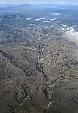 Tonto Creek (right and foreground) with tributary Rye Creek (center background) | |
| Location | |
| Country | United States |
| State | Arizona |
| County | Gila and Coconino |
| Physical characteristics | |
| Source | |
| • coordinates | 34°23′37″N 111°04′52″W[1] |
| • elevation | 7,640 feet (2,330 m)[2] |
| Mouth | |
• location | Theodore Roosevelt Lake |
• coordinates | 33°40′48″N 111°09′05″W[1] |
• elevation | 2,096 feet (639 m)[1] |
| Length | 72.5 miles (116.7 km) |
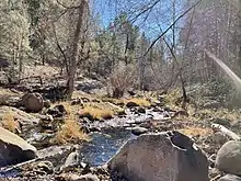
Tonto Creek in Arizona just after Horton Creek joins with Tonto Creek.
Fish species
Fish in the stream include rainbow trout, brown trout, and brook trout.[5]
See also
References
- U.S. Geological Survey Geographic Names Information System: Tonto Creek
- Knoll Lake, AZ, 7.5 Minute Topographic Quadrangle, USGS, 1972
- "The National Map". U.S. Geological Survey. Retrieved March 8, 2011.
- "Tonto Creek, Arizona". John Crossley.
- "Arizona Fishin' Holes". Phoenix, AZ: Arizona Game and Fish Department. 2007. Cite journal requires
|journal=(help)
External links
| Authority control |
|---|
This article is issued from Wikipedia. The text is licensed under Creative Commons - Attribution - Sharealike. Additional terms may apply for the media files.