Topraisar
Topraisar is a commune in the Constanța County, Northern Dobruja, Romania.
Topraisar | |
|---|---|
 Location in Constanța County | |
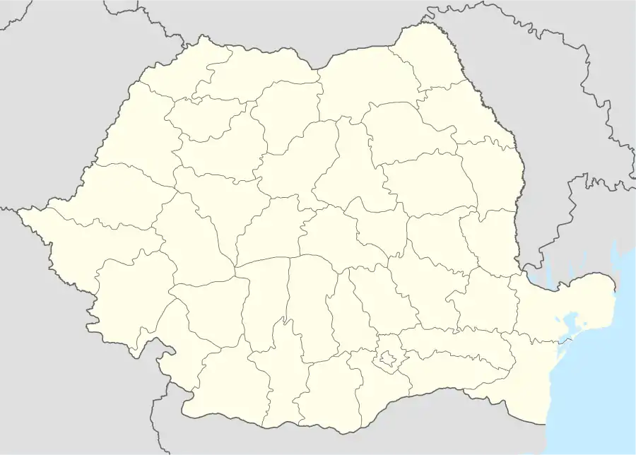 Topraisar Location in Romania | |
| Coordinates: 44°00′36″N 28°27′00″E | |
| Country | |
| County | Constanța |
| Subdivisions | Topraisar, Biruința, Movilița, Potârnichea |
| Government | |
| • Mayor | Gheorghe Stelian (PSD) |
| Area | 131.65 km2 (50.83 sq mi) |
| Population (2011)[1] | 5,533 |
| • Density | 42/km2 (110/sq mi) |
| Time zone | EET/EEST (UTC+2/+3) |
| Vehicle reg. | CT |
| Website | www |
The commune includes four villages:[2]
- Topraisar (historical name: Crimean Tatar: Topraysar[3])
- Biruința (historical name: Crimean Tatar: Muratan,[4] probably rounded out phonetically from Murat Han)
- Movilița (historical name: Crimean Tatar: Musurat,[4] probably rounded out phonetically from Musavvirat;[5] for short periods in the 20th century it has also been named Regele Mihai and Filimon Sîrbu (1948-1964) )
- Potârnichea (historical name: Crimean Tatar: Abdullahköy)[6]
Topraisar and the surrounding areas were the site of fierce fighting in 1916 during two battles of the World War I: the First and Second Battle of Cobadin.
Etymology
Topraysar is of Tatar origin and is rounded out phonetically from Top[5] Rayis[5] Hisar[5] meaning The Fortress of the President of the Union.
Top Rayis meaning The Elected Leader of the Union or The President of the Union appears to designate Queen Tomyris and it seems to stand also at the origin of Dobruja and the ancient city of Tomis.[7]
Some people believe that the name of the commune derivates from Toprak Hisar meaning Earth/Clay Fortress.[8][9]
Demographics
At the 2011 census, Topraisar had 4,758 Romanians (92.42%), 3 Roma (0.06%), 17 Turks (0.33%), 359 Tatars (6.97%), 11 others (0.21%).[10]
References
- "Populaţia stabilă pe judeţe, municipii, oraşe şi localităti componenete la RPL_2011" (in Romanian). National Institute of Statistics. Retrieved 4 February 2014.
- http://www.primaria-topraisar.ro/localizare.htm commune website (in Romanian)
- Lahovari, George Ioan; Brătianu, C.I.; Tocilescu, Grigore G. (1902). Marele dicționar geografic al Romîniei. V. București: Societatea Geografică Romînă.
- Lahovari, George Ioan; Brătianu, C.I.; Tocilescu, Grigore G. (1901). Marele dicționar geografic al Romîniei. IV. București: Societatea Geografică Romînă.
- Murat, Taner (2011). Dicționar tătar crimean-român, Kîrîm Tatarșa-Kazakșa Sózlík. Charleston, SC, USA: CreateSpace. ISBN 9781461083108.
- Lahovari, George Ioan; Brătianu, C.I.; Tocilescu, Grigore G. (1898). Marele dicționar geografic al Romîniei. I. București: Societatea Geografică Romînă.
- Murat, Taner (2012). Opening the Doors of Science. Iaşi: StudIS. pp. 99–104. ISBN 9786066242943.
- Seslisözlük dictionary, Entry for "toprak"
- Seslisözlük dictionary, Entry for "hisar"
- "Constanța County at the 2011 census" (PDF) (in Romanian). INSSE. February 2, 2012. Archived from the original (PDF) on March 24, 2012. Retrieved March 8, 2012.