Trảng Bom District
Trảng Bom is a rural district of Đồng Nai Province in the Southeast region of Vietnam. Located on National Highway 1.
Trảng Bom District
Huyện Trảng Bom | |
|---|---|
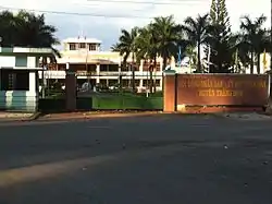 People's Committee of Trảng Bom District | |
| Country | |
| Region | Southeast |
| Province | Đồng Nai |
| Capital | Trảng Bom |
| Area | |
| • Total | 126 sq mi (326 km2) |
| Population (2019) | |
| • Total | 666,439 |
| Time zone | UTC+7 (Indochina Time) |
The village of Trảng Bom was attacked by Viet Cong forces during the 1968 Tet Offensive and in February the Fire support base which contained New Zealand and American artillery and Australian cavalry, engineer, and infantry elements was attacked three times by Viet Cong forces during Operation Coburg but were successfully repelled each time. Trảng Bom was also the site of fierce fighting in April 1975, prior to the fall of Saigon and the end of the Republic of Vietnam.
As of 2003 the district had a population of 192,627.[1] The district covers an area of 326 km². The district capital lies at Trảng Bom.[1]
Administrative divisions
In the district there are 16 municipalities:
- An Viễn
- Bàu Hàm 1
- Bắc Sơn
- Bình Minh, Trảng Bom
- Cây Gáo
- Đông Hòa
- Đồi 61
- Giang Điền
- Hố Nai 3
- Hưng Thịnh
- Quảng Tiến
- Sông Thao
- Sông Trầu
- Tây Hòa
- Thanh Bình
- Trung Hòa
References
- "Districts of Vietnam". Statoids. Retrieved March 13, 2009.
| Ho Chi Minh City | 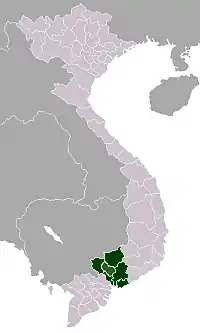 | |
|---|---|---|
| Bà Rịa-Vũng Tàu Province | ||
| Bình Dương Province |
| |
| Bình Phước Province |
| |
| Đồng Nai Province | ||
| Tây Ninh Province |
| |
※ denotes provincial seat | ||