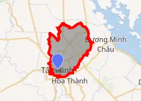
Tây Ninh
Tây Ninh (![]() listen) is a provincial city in south-eastern Vietnam. It is the capital of Tây Ninh Province, which encompasses the town and much of the surrounding farmland. Tây Ninh is approximately 90 km to the northwest of Ho Chi Minh City, Vietnam's largest city. As of 2013, the city had a population of 153,537, and a total area of 140 km².[1]
listen) is a provincial city in south-eastern Vietnam. It is the capital of Tây Ninh Province, which encompasses the town and much of the surrounding farmland. Tây Ninh is approximately 90 km to the northwest of Ho Chi Minh City, Vietnam's largest city. As of 2013, the city had a population of 153,537, and a total area of 140 km².[1]

Tây Ninh
Thành phố Tây Ninh | |
|---|---|
| Tây Ninh City | |
 | |
| |
| Coordinates: 11°22′4″N 106°07′8″E | |
| Country | |
| Province | Tây Ninh |
| Area | |
| • Total | 140 km2 (50 sq mi) |
| Population (2013) | |
| • Total | 153,537 |
| • Density | 1,096.6/km2 (2,840/sq mi) |
| Time zone | UTC+07 (ICT) |
The city is most famous for being the home of the Cao Đài religion, an indigenous Vietnamese faith that includes the teachings of the major world religions. The Cao Đài religion's Holy See, built between 1933 and 1955, is located around 5 km to the east of Tây Ninh's city centre.
Besides the Cao Đài Holy See, other tourist attractions include Núi Bà Đen ("Black Virgin Mountain") and Dầu Tiếng Lake, one of the largest man-made lakes in Vietnam and Southeast Asia.
In The Quiet American by Graham Greene, Tây Ninh is referred to as "Tanyin."
History
After the Fall of Saigon, the town of Tây Ninh was reorganized to comprise 3 wards and 1 commune. In August 2001, the town was expanded to include 5 wards and 5 communes. On 29 December 2013, Tây Ninh town was upgraded officially to provincial city status, under administration of Tây Ninh Province, along with the upgrade of its two communes Ninh Sơn and Ninh Thạnh to ward status.[1]
Climate
| Climate data for Tây Ninh | |||||||||||||
|---|---|---|---|---|---|---|---|---|---|---|---|---|---|
| Month | Jan | Feb | Mar | Apr | May | Jun | Jul | Aug | Sep | Oct | Nov | Dec | Year |
| Record high °C (°F) | 36.2 (97.2) |
36.4 (97.5) |
38.5 (101.3) |
39.9 (103.8) |
39.0 (102.2) |
37.6 (99.7) |
37.3 (99.1) |
35.2 (95.4) |
35.6 (96.1) |
34.0 (93.2) |
34.3 (93.7) |
34.8 (94.6) |
39.9 (103.8) |
| Average high °C (°F) | 32.1 (89.8) |
33.4 (92.1) |
34.8 (94.6) |
35.2 (95.4) |
34.0 (93.2) |
32.5 (90.5) |
31.9 (89.4) |
31.6 (88.9) |
31.3 (88.3) |
31.0 (87.8) |
31.2 (88.2) |
31.0 (87.8) |
32.5 (90.5) |
| Daily mean °C (°F) | 25.6 (78.1) |
26.6 (79.9) |
27.9 (82.2) |
28.8 (83.8) |
28.3 (82.9) |
27.4 (81.3) |
27.0 (80.6) |
27.0 (80.6) |
26.7 (80.1) |
26.4 (79.5) |
26.0 (78.8) |
25.2 (77.4) |
26.9 (80.4) |
| Average low °C (°F) | 20.9 (69.6) |
21.9 (71.4) |
23.3 (73.9) |
24.8 (76.6) |
25.0 (77.0) |
24.4 (75.9) |
24.1 (75.4) |
24.2 (75.6) |
24.0 (75.2) |
23.6 (74.5) |
22.7 (72.9) |
21.0 (69.8) |
23.3 (73.9) |
| Record low °C (°F) | 15.3 (59.5) |
17.9 (64.2) |
16.8 (62.2) |
21.4 (70.5) |
21.9 (71.4) |
19.3 (66.7) |
20.8 (69.4) |
21.2 (70.2) |
20.3 (68.5) |
18.5 (65.3) |
16.9 (62.4) |
13.9 (57.0) |
13.9 (57.0) |
| Average precipitation mm (inches) | 13 (0.5) |
11 (0.4) |
24 (0.9) |
104 (4.1) |
203 (8.0) |
265 (10.4) |
257 (10.1) |
234 (9.2) |
353 (13.9) |
317 (12.5) |
139 (5.5) |
48 (1.9) |
1,967 (77.4) |
| Average precipitation days | 1.7 | 1.6 | 2.8 | 7.4 | 16.0 | 20.5 | 21.8 | 21.6 | 23.6 | 21.9 | 11.6 | 3.8 | 154.4 |
| Average relative humidity (%) | 70.5 | 70.8 | 70.2 | 73.2 | 79.7 | 83.5 | 84.1 | 84.5 | 85.9 | 85.0 | 79.4 | 72.8 | 78.3 |
| Mean monthly sunshine hours | 257 | 244 | 277 | 250 | 238 | 192 | 201 | 186 | 181 | 194 | 215 | 235 | 2,672 |
| Source: Vietnam Institute for Building Science and Technology[2] | |||||||||||||
Administrative division
Tây Ninh city, Vietnam comprises 7 wards (phường) and 3 communes (xã):
- Ward 1
- Ward 2
- Ward 3
- Ward 4
- Hiệp Ninh Ward
- Ninh Sơn Ward
- Ninh Thạnh Ward
- Bình Minh Commune
- Tân Bình Commune
- Thạnh Tân Commune
The ward is further divided into quarters (khu phố) and the commune into hamlets (ấp).

References
- "Resolution on establishing Tay Ninh City". Tay Ninh Portal. Retrieved 9 Feb 2014.
- "Vietnam Building Code Natural Physical & Climatic Data for Construction" (PDF) (in Vietnamese). Vietnam Institute for Building Science and Technology. Archived from the original (PDF) on 22 July 2018. Retrieved 23 July 2018.
External links
| Wikimedia Commons has media related to Tay Ninh City. |
 Tây Ninh travel guide from Wikivoyage
| Ho Chi Minh City | 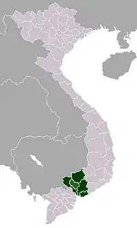 | |
|---|---|---|
| Bà Rịa-Vũng Tàu Province | ||
| Bình Dương Province |
| |
| Bình Phước Province |
| |
| Đồng Nai Province | ||
| Tây Ninh Province |
| |
※ denotes provincial seat | ||