Tracy, California
Tracy is the second most populated city in San Joaquin County, California, United States. The population was 82,922 at the 2010 census. Tracy is located inside a geographic triangle formed by Interstate 205 on the north side of the city, Interstate 5 to the east, and Interstate 580 to the southwest. Tracy's motto, included on the city's website, is: "Think Inside The Triangle".[10]
Tracy, California | |
|---|---|
City in California | |
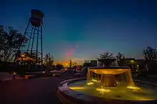
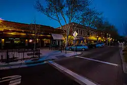 Downtown Tracy | |
| Motto(s): Think Inside the Triangle | |
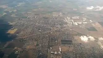
 Location in San Joaquin County and the state of California | |
 Tracy Location in the United States | |
| Coordinates: 37°44′17″N 121°26′2″W | |
| Country | United States |
| State | California |
| County | San Joaquin |
| Incorporated | July 22, 1911[1] |
| Government | |
| • Type | City Manager[2] |
| • Mayor | Robert Rickman[3] |
| • Manager | Jennifer D. Haruyama |
| • State senator | Susan Eggman (D)[4] |
| • Assembly member | Carlos Villapudua (D)[4] |
| • U. S. rep. | Josh Harder (D)[5] |
| Area | |
| • Total | 26.03 sq mi (67.42 km2) |
| • Land | 25.90 sq mi (67.07 km2) |
| • Water | 0.14 sq mi (0.35 km2) 0.61% |
| Elevation | 52 ft (16 m) |
| Population | |
| • Total | 82,922 |
| • Estimate (2019)[9] | 94,740 |
| • Rank | 80th in California |
| • Density | 3,658.34/sq mi (1,412.50/km2) |
| Time zone | UTC−8 (Pacific) |
| • Summer (DST) | UTC−7 (PDT) |
| ZIP codes | 95304, 95376–95378, 95385, 95391 |
| Area code | 209 |
| FIPS code | 06-80238 |
| GNIS feature IDs | 277621, 2412090 |
| Website | cityoftracy |
History
Until the 1760s, the area that is now the city of Tracy was long populated by the Yokuts tribe of loosely associated bands of Native Americans and their ancestors. They lived on hunting and gathering foods, game and fish from the area, including its local rivers and creeks. After encountering the Spanish colonists, the Yokuts suffered from new infectious diseases, which caused social disruption, as did the Spanish efforts to impress them for labor at missions. Mexican and American explorers later came into the area, pushing the Yokuts out.[11]
Tracy developed from the mid-19th century construction of Central Pacific Railroad lines running from Sacramento through Stockton and to the San Francisco Bay Area. Tracy is part of the San Jose-San Francisco-Oakland, CA Combined Statistical Area, an extension of the Bay Area. A number of small communities sprang up along these lines at designated station sites, including one named for railroad director Lathrop J. Tracy.
Incorporated in 1911, Tracy grew rapidly and prospered as the center of an agricultural area, even when as larger railroad operations began to decline in the 1950s. Competition with trucking and automobiles resulted in widespread railroad restructuring.
In December 1969, the town of Tracy was the host of the Altamont Free Concert, held at the (now closed) Altamont Raceway Park. An estimated 300,000 people gathered at the speedway infield in an event that was plagued by violence among attendees, many of whom were drunk or drugged. Artists featured included the internationally known Rolling Stones, Santana, Jefferson Airplane, The Flying Burrito Brothers and Crosby, Stills, Nash & Young.
Geography
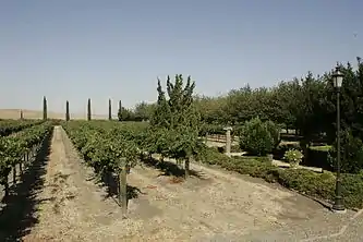
Located in the Greater Bay Area, Tracy is near both fertile and (due to a region of hills west of Tracy) infertile agricultural lands. Tracy has a Mediterranean climate.
Some of this land (in the east and mostly north of Tracy because of the moist Delta river system) has come under increasing development pressure. The San Francisco Bay Area's vigorous population growth has spilled over into the Tracy area as well as other locations, such as the new town of Mountain House. Tracy passed Measure A in 1990 to try to contain and limit development.
In an effort to reduce environmental impacts of the city, it launched the Emerald Tracy Project in September 2009. City spokesman Matt Robinson said that if it succeeds, Tracy will be the second city after Riverside, California to satisfy the state's goal for sustainable communities.
Tire fire, south of Tracy
On August 7, 1998, a tire fire ignited at S.F. Royster's Tire Disposal south of Tracy at 29425 South MacArthur Drive, near Linne Road. The tire dump held more than 7 million illegally stored tires and was allowed to burn for over two years before it was extinguished. Allowing the fire to burn was considered to be a better way to avoid groundwater contamination than putting it out.[12] The cleanup of chemicals released by the fire cost $16.2 million. The chemicals were found to have contaminated groundwater in the region after all.[13][14]
Climate
Tracy is marked by a semi-arid climate (Köppen BSh), with mild, moist winters and very hot and dry summers, displaying Mediterranean characteristics. December and January are the coolest months, and average around 47.1 °F (8.4 °C), and there are 19 nights with lows at or below freezing annually, with the coldest night of the year typically bottoming out below 30 °F (−1.1 °C).[15] July is the warmest month, averaging 76.4 °F (28.3 °C); normally, there are 18 days of 100 °F (37.8 °C)+ highs and 82 days of 90 °F (32.2 °C)+ highs. Average annual precipitation is around 12.5 inches (317.7 mm), which, by definition, results in the area being classified as a semi-desert.
| Climate data for Tracy, California (Pumping Plant) | |||||||||||||
|---|---|---|---|---|---|---|---|---|---|---|---|---|---|
| Month | Jan | Feb | Mar | Apr | May | Jun | Jul | Aug | Sep | Oct | Nov | Dec | Year |
| Average high °F (°C) | 55.6 (13.1) |
62.4 (16.9) |
67.2 (19.6) |
73.5 (23.1) |
80.0 (26.7) |
87.3 (30.7) |
92.5 (33.6) |
91.8 (33.2) |
88.0 (31.1) |
79.2 (26.2) |
65.1 (18.4) |
55.6 (13.1) |
74.9 (23.8) |
| Average low °F (°C) | 38.5 (3.6) |
41.3 (5.2) |
44.8 (7.1) |
48.2 (9.0) |
53.5 (11.9) |
57.4 (14.1) |
60.2 (15.7) |
59.9 (15.5) |
58.3 (14.6) |
52.8 (11.6) |
44.9 (7.2) |
38.4 (3.6) |
49.9 (9.9) |
| Average precipitation inches (mm) | 2.61 (66) |
2.31 (59) |
1.97 (50) |
0.73 (19) |
0.45 (11) |
0.10 (2.5) |
0.04 (1.0) |
0.06 (1.5) |
0.25 (6.4) |
0.72 (18) |
1.61 (41) |
1.66 (42) |
12.51 (317.4) |
| Average precipitation days (≥ 0.1 in) | 10.5 | 8.9 | 9.0 | 4.1 | 2.3 | 0.7 | 0.2 | 0.4 | 1.0 | 2.8 | 7.0 | 8.3 | 55.2 |
| Source: NOAA[16] | |||||||||||||
Demographics
| Historical population | |||
|---|---|---|---|
| Census | Pop. | %± | |
| 1930 | 3,829 | — | |
| 1940 | 4,056 | 5.9% | |
| 1950 | 8,410 | 107.3% | |
| 1960 | 11,289 | 34.2% | |
| 1970 | 14,724 | 30.4% | |
| 1980 | 18,428 | 25.2% | |
| 1990 | 33,558 | 82.1% | |
| 2000 | 56,929 | 69.6% | |
| 2010 | 82,922 | 45.7% | |
| 2019 (est.) | 94,740 | [9] | 14.3% |
| U.S. Decennial Census[17] | |||
The 2010 United States Census[18] reported that Tracy had a population of 82,922. The population density was 3,745.5 people per square mile (1,446.2/km2). The racial makeup of Tracy was 43,724 (52.7%) White, 5,953 (7.2%) African American, 715 (0.9%) Native American, 12,229 (14.7%) Asian, 747 (0.9%) Pacific Islander, 13,173 (15.9%) from other races, and 6,381 (7.7%) from two or more races. Hispanic or Latino of any race were 30,557 persons (36.9%).
The Census reported that 82,606 people (99.6% of the population) lived in households, 69 (0.1%) lived in non-institutionalized group quarters, and 247 (0.3%) were institutionalized.
There were 24,331 households, out of which 13,143 (54.0%) had children under the age of 18 living in them, 15,122 (62.2%) were opposite-sex married couples living together, 3,196 (13.1%) had a female householder with no husband present, and 1,627 (6.7%) had a male householder with no wife present. There were 1,501 (6.2%) unmarried opposite-sex partnerships, and 184 (0.8%) same-sex married couples or partnerships. 3,326 households (13.7%) were made up of individuals, and 1,026 (4.2%) had someone living alone who was 65 years of age or older. The average household size was 3.40. There were 19,945 families (82.0% of all households); the average family size was 3.72.
The population was spread out, with 26,668 people (32.2%) under the age of 18, 7,476 people (9.0%) aged 18 to 24, 23,826 people (28.7%) aged 25 to 44, 19,202 people (23.2%) aged 45 to 64, and 5,750 people (6.9%) who were 65 years of age or older. The median age was 32.3 years. For every 100 females, there were 98.3 males. For every 100 females age 18 and over, there were 94.9 males.
There were 25,963 housing units at an average density of 1,172.7 per square mile (452.8/km2), of which 16,163 (66.4%) were owner-occupied, and 8,168 (33.6%) were occupied by renters. The homeowner vacancy rate was 2.5%; the rental vacancy rate was 5.9%. 54,275 people (65.5% of the population) lived in owner-occupied housing units and 28,331 people (34.2%) lived in rental housing units.
Government and infrastructure
The United States Postal Service operates the Tracy Post Office[19] and the Tracy Carrier Annex.[20]
The California Department of Corrections and Rehabilitation operates the Deuel Vocational Institution, a state prison, in unincorporated San Joaquin County, near Tracy.[21][22]
School districts
Three public school districts serve the city of Tracy. The largest and most recognized is the Tracy Unified School District. This school system incorporates many elementary and middle schools as well as six Tracy high schools: Tracy High School, Merrill F. West High School, Delta Charter High School, Millennium Charter High School, John C. Kimball High School, and Mountain House High School, which opened in 2014. However, Mountain House High School is open only to Mountain House residents.
Tracy's students with behavioral issues attend the Willow Community Day School, and the Tracy One Program, or Community One. The other two school districts are: Lammersville Joint Unified School District and Jefferson School District. The latter covers the south side of Tracy and includes four schools: Jefferson Middle School, Tom Hawkins Elementary School, Monticello Elementary School and Anthony C. Traina School.
Transportation
Public transportation
Tracy is served by several bus services: locally, Tracer runs seven lines that serve as circulators between major transit hubs, shopping, school, residential, and downtown areas. San Joaquin Regional Transit District (SJRTD) runs two county hopper routes that connect the city with other San Joaquin County communities and one commuter route that run to Dublin/Pleasanton BART station.
Greyhound, Tracer, and SJRTD all connect with taxis, bike stations, and parking at the Tracy Transit Center, a transit station built in 2010.
Amtrak Buses connect serve the city's Amtrak Bus Station to the area with six daily trips to the South Bay and two to San Francisco, all of which stop at BART and job centers in Livermore.
To meet the future transportation needs, which will connect San Joaquin Valley with the Bay Area, there are two Transit Stations in Tracy. One is located downtown and is designated for bus service, but is being considered as a possible site for California High-Speed Rail.
South Tracy offers the Altamont Corridor Express (ACE) service at Tracy (ACE station), which provides commuter rail transportation to the Bay Area and connects with VTA in San Jose, BART via shuttle in Pleasanton and Fremont, in addition to Amtrak train in Santa Clara and San Jose.
Major highways
Interstate 205 passes along the north side of the city and connects the nearby Interstates 580 to the west and 5 on the east, with the three Interstates forming a triangle around much of the city. Business Loop 205 runs through the center of Tracy along 11th Street, formerly a portion of U.S. Highway 50. In addition, the northern terminus of State Highway 33 is located at South Bird Road and Interstate 5 southeast of Tracy.
Aviation
Tracy is served by Tracy Municipal Airport, located south of the city. It serves general aviation; there is no scheduled airline service from the airport.
Local media
Tracy's daily newspaper is the Tracy Press, a once-weekly newspaper owned since the 19th century by the Matthews family. Bilingual Weekly News covers Tracy in English and Spanish.
Sister cities
Tracy has been a sister city of Memuro, Hokkaido since 1989. The city is also a sister city of Velas in the Azores.[23]
Media exposure
- Tracy was mentioned in Hunter S. Thompson's book Hell's Angels: The Strange and Terrible Saga of the Outlaw Motorcycle Gangs, because of the events at Altamont. The concert was the subject of the 1970 documentary film Gimme Shelter.
- Tracy was mentioned in Jack Kerouac's book On the Road.
- The parade scene in the film The Candidate, starring Robert Redford, was filmed in Tracy.
- The 1975 Academy Award-nominated documentary The California Reich depicts members of the American Nazi Party living in Tracy.
- The Tracy High School football field and MVP trophy are named after Peter B. Kyne, a novelist from San Francisco whose Bohemian Club friends orchestrated the naming in 1927, even though Kyne had very little to do with Tracy. It was renamed for long time Tracy High football coach Wayne Schneider in 2012 after the field was completely rebuilt.
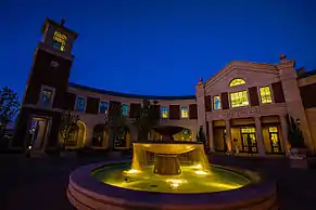
- Kathy Griffin recorded her CD Kathy Griffin: For Your Consideration live on February 17, 2008 at the ETK Theatre at the Grand Theatre Center for the Arts in Tracy.
- In 2009 this city made national headlines because of a brutal crime, the body of 8-year-old Sandra Cantu was found during routine draining of an irrigation pond. An autopsy established that Cantu had been beaten and sexually abused with a foreign object before being smothered, while toxicology results showed that she had ingested Alprazolam. Melissa Huckaby a then 28-year-old Sunday school teacher was found guilty of her murder and was sentenced to life imprisonment without the possibility of parole.[24]
Notable people
- Sandra Cantu – homicide victim in 2009
- Troy Dayak – soccer player/coach
- Nick Eddy – former NFL player
- MC Hammer – rapper, dancer, entertainer, actor, business entrepreneur
- Rod Lauren – singer/actor
- Thia Megia – singer, finalist on American Idol season ten.
- Matt Overton – active NFL player- Jacksonville Jaguars
- Steve Perry – Singer from Journey (Banta)
- Richard Pombo – former United States Representative
- Keena Turner – football star
- Bubba Paris - former NFL football star
- Sal Khan - Khan Academy
References
- "California Cities by Incorporation Date". California Association of Local Agency Formation Commissions. Archived from the original (Word) on November 3, 2014. Retrieved August 25, 2014.
- "City of Tracy Government Structure". City of Tracy. Retrieved March 23, 2015.
- "Mayor Robert Rickman". City of Tracy. Retrieved January 30, 2017.
- "Statewide Database". UC Regents. Archived from the original on February 1, 2015. Retrieved November 23, 2014.
- "California's 10th Congressional District - Representatives & District Map". Civic Impulse, LLC. Retrieved March 12, 2013.
- "2019 U.S. Gazetteer Files". United States Census Bureau. Retrieved July 1, 2020.
- "Tracy". Geographic Names Information System. United States Geological Survey. Retrieved December 16, 2014.
- "Tracy (city) QuickFacts". United States Census Bureau. Archived from the original on April 26, 2015. Retrieved February 9, 2015.
- "Population and Housing Unit Estimates". United States Census Bureau. May 24, 2020. Retrieved May 27, 2020.
- "City of Tracy: Residents". Retrieved October 15, 2020.
- Tracy History tracymuseum.org
- Rubber Threat: Tracy tire fire highlights old problem. Lodi News-Sentinel. August 18, 1998.
- Breitler, Alex. "Byproducts from 1998 tire fire found in water". Record. December 20, 2005.
- California Integrated Waste Management Board. "Removal Action Summary Report, pp.28–29" (PDF). California Department of Toxic Substances Control. Retrieved September 12, 2010.
- Team, National Weather Service Corporate Image Web. "National Weather Service – NWS Sacramento". w2.weather.gov. Retrieved April 7, 2018.
- "Climatography of the United States No. 20: Tracy Pumping Plant, CA 1971–2000" (PDF). National Oceanic and Atmospheric Administration. Archived from the original (PDF) on August 16, 2014. Retrieved October 22, 2012.
- "Census of Population and Housing". Census.gov. Retrieved June 4, 2015.
- "2010 Census Interactive Population Search: CA – Tracy city". U.S. Census Bureau. Archived from the original on July 15, 2014. Retrieved July 12, 2014.
- "TRACY Post Office". United States Postal Service. Retrieved March 7, 2018.
- "TRACY CARRIER ANNEX". United States Postal Service. Retrieved March 7, 2018.
- "Deuel Vocational Institution." California Department of Corrections and Rehabilitation. Retrieved June 6, 2011. "23500 Kasson Road Tracy, CA 95376"
- "Tracy city, California Archived February 3, 2008, at the Wayback Machine." U.S. Census Bureau. Retrieved June 6, 2011.
- Matthews, Sam (March 14, 2014). "Japanese visitors celebrate sister city". Tracy Press. Retrieved April 15, 2015.
- Ferran, Lee; NETTER, SARAH (May 10, 2010). "Melissa Huckaby Pleads Guilty to Sandra Cantu's Murder". ABC News.
External links
| Wikimedia Commons has media related to Tracy, California. |
- Official website

- Tracy Press website
- Tracy Unified School District
- Tracy Chamber of Commerce website
- Railtown Tracy Project (San Joaquin Valley Railroad Museum)
Municipalities and communities of San Joaquin County, California, United States | ||
|---|---|---|
| Cities | 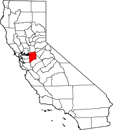 San Joaquin County map | |
| CDPs | ||
| Unincorporated communities | ||
| Ghost towns | ||
| ||
| Authority control |
|---|