Traiguera
Traiguera is a town and municipality in the Baix Maestrat comarca, province of Castelló, Valencian Community, Spain. It is part of the Taula del Sénia free association of municipalities.
Traiguera | |
|---|---|
 Coat of arms | |
 Traiguera Location in Spain | |
| Coordinates: 40°31′32″N 0°17′26″E | |
| Country | |
| Autonomous community | |
| Province | Castelló |
| Comarca | Plana Alta |
| Judicial district | Vinaròs |
| Area | |
| • Total | 59.8 km2 (23.1 sq mi) |
| Elevation | 271 m (889 ft) |
| Population (2018)[1] | |
| • Total | 1,375 |
| • Density | 23/km2 (60/sq mi) |
| Demonym(s) | Traiguerí, traiguerina |
| Time zone | UTC+1 (CET) |
| • Summer (DST) | UTC+2 (CEST) |
| Postal code | 12330 |
| Official language(s) | Valencian |
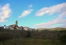
The town is located in a central position in the comarca, north of the Muntanyes de Cervera. The Serra de Sant Pere mountain range rises on the western side of Traiguera. This town was mentioned as part of Ilercavonia by Ptolemy.
Besides Mediterranean agriculture, mainly almonds, olives and oranges, the town has a traditional ceramic industry, much affected now by the current crisis.[2] The name of the place 'Traiguera' comes from Aegilops geniculata, a coarse cereal that was cultivated until the Middle Ages.[3]
One of the main tourist attractions is the Santuari de la Font de la Salut, located among mountains 2 km south of the town.
Villages
- Traiguera
- Font de la Salut
- Masia Avenc
References
- Municipal Register of Spain 2018. National Statistics Institute.
- Paco González Ramírez - El País Valencià, poble a poble, comarca a comarca
- Diccionari Alcover-Moll
External links
| Wikimedia Commons has media related to Traiguera. |
- Web oficial de l'Ajuntament de Traiguera
- Informació de Traiguera
- Imatge de Traiguera: Memòria visual del Segle XX
- País Valencià, poble a poble, comarca a comarca, de Paco González Ramírez, d'on se n'ha tret informació amb el seu consentiment.
- Institut Valencià d'Estadística.
- Portal de la Direcció General d'Administració Local de la Generalitat.
Municipalities of Baix Maestrat | ||
|---|---|---|
| Authority control |
|
|---|
