Trois-Pistoles, Quebec
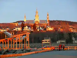
Trois-Pistoles is a city in Les Basques Regional County Municipality in the Bas-Saint-Laurent region of Quebec, Canada. It is also the county seat. The town is located on the south shore of the Saint Lawrence River.
Trois-Pistoles | |
|---|---|
 | |
.svg.png.webp) Coat of arms | |
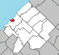 Location within Les Basques RCM | |
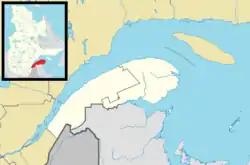 Trois-Pistoles Location in eastern Quebec  Trois-Pistoles Trois-Pistoles (Canada) | |
| Coordinates: 48°07′12″N 069°10′48″W[1] | |
| Country | Canada |
| Province | Quebec |
| Region | Bas-Saint-Laurent |
| RCM | Les Basques |
| Constituted | 9 March 1916 |
| Government | |
| • Mayor | Jean-Pierre Rioux |
| • Federal riding | Rimouski-Neigette—Témiscouata —Les Basques |
| • Prov. riding | Rivière-du-Loup–Témiscouata |
| Area | |
| • Total | 9.60 km2 (3.71 sq mi) |
| • Land | 7.66 km2 (2.96 sq mi) |
| Population | |
| • Total | 3,456 |
| • Density | 450.9/km2 (1,168/sq mi) |
| • Pop 2006–2011 | |
| • Dwellings | 1,757 |
| Time zone | UTC−05:00 (EST) |
| • Summer (DST) | UTC−04:00 (EDT) |
| Postal code(s) | G0L 4K0 |
| Area code(s) | 418 and 581 |
| Highways | |
| Website | www |
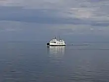
A ferry crosses the river to Les Escoumins on the north shore. The port facilities are also used by fishing boats and scuba divers.
The town is the site of the University of Western Ontario's annual French immersion program, which has existed since 1932. It is the oldest such program in Canada.
Just offshore of the town lies Île aux Basques, an island that was used by Basque whalers in the 16th century. The island, part of the surrounding Municipality of Notre-Dame-des-Neiges, is a National Historic Site of Canada and is now a migratory bird sanctuary.[4]
The town has hosted the Festival Échofête de Trois-Pistoles, an environmentalism-themed music festival and fair each July since 2002. It is Quebec's largest environmental festival.[5][6]
The town can be reached by Via Rail on the named train The Ocean, between Montreal and Halifax.
Etymology
The town is said to have been named for a silver goblet worth three pistoles, an old French coin, that was lost in the river in the 17th century.[1]
Demographics
Population
| Canada census – Trois-Pistoles, Quebec community profile | |||
|---|---|---|---|
| 2011 | 2006 | ||
| Population: | 3,456 (-1.3% from 2006) | 3,500 (-3.7% from 2001) | |
| Land area: | 7.66 km2 (2.96 sq mi) | 7.66 km2 (2.96 sq mi) | |
| Population density: | 450.9/km2 (1,168/sq mi) | 456.7/km2 (1,183/sq mi) | |
| Median age: | 55.2 (M: 53.0, F: 56.7) | 50.7 (M: 48.3, F: 52.2) | |
| Total private dwellings: | 1,757 | 1,720 | |
| Median household income: | $38,395 | $33,939 | |
| References: 2011[7] 2006[8] earlier[9] | |||
| Year | Pop. | ±% |
|---|---|---|
| 1991 | 3,886 | — |
| 1996 | 3,807 | −2.0% |
| 2001 | 3,635 | −4.5% |
| 2006 | 3,500 | −3.7% |
| 2011 | 3,253 | −7.1% |
| 2016 | 3,058 | −6.0% |
Language
| Canada Census Mother Tongue – Trois-Pistoles, Quebec[10] | ||||||||||||||||||
|---|---|---|---|---|---|---|---|---|---|---|---|---|---|---|---|---|---|---|
| Census | Total | French |
English |
French & English |
Other | |||||||||||||
| Year | Responses | Count | Trend | Pop % | Count | Trend | Pop % | Count | Trend | Pop % | Count | Trend | Pop % | |||||
2011 |
3,395 |
3,375 | 99.41% | 15 | 0.44% | 5 | 0.15% | 0 | 0.00% | |||||||||
2006 |
3,250 |
3,195 | 98.31% | 0 | 0.00% | 0 | 0.00% | 55 | 1.69% | |||||||||
2001 |
3,430 |
3,405 | 99.27% | 25 | 0.73% | 0 | 0.00% | 0 | 0.00% | |||||||||
1996 |
3,580 |
3,535 | n/a | 98.74% | 35 | n/a | 0.98% | 10 | n/a | 0.28% | 0 | n/a | 0.00% | |||||
Climate
| Climate data for Trois-Pistoles | |||||||||||||
|---|---|---|---|---|---|---|---|---|---|---|---|---|---|
| Month | Jan | Feb | Mar | Apr | May | Jun | Jul | Aug | Sep | Oct | Nov | Dec | Year |
| Record high °C (°F) | 12 (54) |
11 (52) |
17.8 (64.0) |
27 (81) |
31.7 (89.1) |
32 (90) |
35 (95) |
33.9 (93.0) |
31 (88) |
23.3 (73.9) |
21 (70) |
15 (59) |
35 (95) |
| Average high °C (°F) | −8 (18) |
−6.4 (20.5) |
−0.4 (31.3) |
6.4 (43.5) |
14.3 (57.7) |
20.2 (68.4) |
23 (73) |
21.4 (70.5) |
16 (61) |
9.4 (48.9) |
2.4 (36.3) |
−4.7 (23.5) |
7.8 (46.0) |
| Daily mean °C (°F) | −12 (10) |
−10.1 (13.8) |
−4.2 (24.4) |
2.5 (36.5) |
9.3 (48.7) |
15 (59) |
17.7 (63.9) |
16.5 (61.7) |
11.6 (52.9) |
5.9 (42.6) |
−0.5 (31.1) |
−8.1 (17.4) |
3.6 (38.5) |
| Average low °C (°F) | −15.8 (3.6) |
−13.9 (7.0) |
−8.1 (17.4) |
−1.4 (29.5) |
4.2 (39.6) |
9.7 (49.5) |
12.5 (54.5) |
11.5 (52.7) |
7.2 (45.0) |
2.4 (36.3) |
−3.3 (26.1) |
−11.4 (11.5) |
−0.6 (30.9) |
| Record low °C (°F) | −34.4 (−29.9) |
−31.7 (−25.1) |
−25.5 (−13.9) |
−18 (0) |
−7.2 (19.0) |
0 (32) |
3.3 (37.9) |
1.7 (35.1) |
−2.8 (27.0) |
−7.8 (18.0) |
−18 (0) |
−28.5 (−19.3) |
−34.4 (−29.9) |
| Average precipitation mm (inches) | 83.9 (3.30) |
67.8 (2.67) |
77.3 (3.04) |
73.9 (2.91) |
88.3 (3.48) |
84.2 (3.31) |
93.3 (3.67) |
87.6 (3.45) |
90.5 (3.56) |
92.5 (3.64) |
78.3 (3.08) |
87.6 (3.45) |
1,005.3 (39.58) |
| Source: Environment Canada[11] | |||||||||||||
Media
- FM 93.9 – CIEL-FM-4, adult contemporary
- FM 104.9 – CIBM-FM-2, hot adult contemporary
See also
- List of cities in Quebec
- Trois Pistoles station
- Trois-Pistoles, a Belgian-style beer from Unibroue, a Quebec brewery now owned by Sapporo Brewery.
References
- "Trois-Pistoles" (in French). Commission de toponymie du Québec. 28 June 2011. Retrieved 15 January 2012.
- Geographic code 11040 in the official Répertoire des municipalités (in French)
- "(Code 2411040) Census Profile". 2011 census. Statistics Canada. 2012.
- http://www.bonjourquebec.com/qc-en/attractions-directory/cruise-company/excursions-a-lile-aux-basques_1899812.html
- http://www.echofete.ca/
- http://www.bonjourquebec.com/qc-en/events-directory/festival-special-event/echofete-festival-eco-culturel_133944335.html
- "2011 Community Profiles". 2011 Canadian Census. Statistics Canada. 5 July 2013. Retrieved 11 February 2014.
- "2006 Community Profiles". 2006 Canadian Census. Statistics Canada. 30 March 2011. Retrieved 11 February 2014.
- "2001 Community Profiles". 2001 Canadian Census. Statistics Canada. 17 February 2012.
- Statistics Canada: 1996, 2001, 2006, 2011 census
- Environment Canada Canadian Climate Normals 1971–2000, accessed 28 April 2010
External links
| Wikimedia Commons has media related to Trois-Pistoles. |
- (in French) Ville de Trois-Pistoles
Adjacent Municipal Subdivisions | ||||||||||
|---|---|---|---|---|---|---|---|---|---|---|
| ||||||||||
| Cities & Towns | |
|---|---|
| Municipalities | |
| Parishes | |
| Unorganized territories | |
| |