Tsingy de Bemaraha Strict Nature Reserve
Tsingy de Bemaraha Strict Nature Reserve is a nature reserve located near the western coast of Madagascar in Melaky Region at 18°40′S 44°45′E. The area was listed as a UNESCO World Heritage Site in 1990 due to the unique geography, preserved mangrove forests, and wild bird and lemur populations.[1][2]
| Bemaraha National Park | |
|---|---|
IUCN category Ia (strict nature reserve) | |
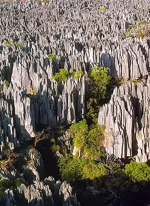
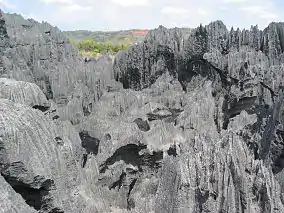 A karst limestone formation, known as tsingy in Malagasy | |
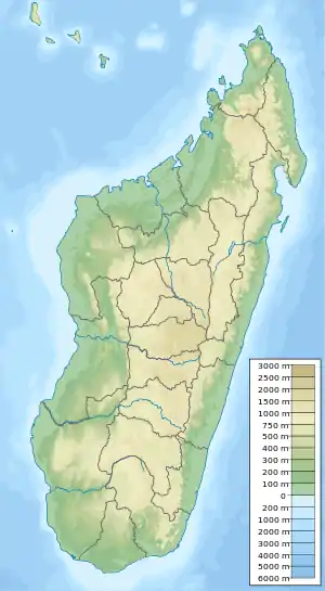 Location of Bemaraha National Park | |
| Location | Western Madagascar |
| Nearest city | Morondava, Antsalova |
| Coordinates | 18°40′S 44°45′E |
| Area | 853 km² |
| Established | 1997 |
| Visitors | approx. 6000 (in 2005) |
| Governing body | Parcs Nationaux Madagascar - ANGAP |
| Official name | Tsingy de Bemaraha Strict Nature Reserve |
| Type | Natural |
| Criteria | vii, x |
| Designated | 1990 (14th session) |
| Reference no. | 494rev |
| State Party | Madagascar |
| Region | Africa |
National Park
The southern end of the protected area has subsequently been changed into the Tsingy de Bemaraha National Park, covering 666 square kilometres (257 sq mi). The northern end of the protected area remains as a strict nature reserve (Réserve Naturelle Intégrale) covering 853 square kilometres (329 sq mi). It is characterised by needle-shaped limestone formations, above cliffs over the Manambolo River.[3] The incredibly sharp limestone formations can cut through equipment and flesh easily, which makes traversing them extremely difficult. The word "Tsingy" is derived from a local word meaning "the place where one cannot walk barefoot".
Tourism
Tourists can access the national park by road from Morondava, a town 150 km south of the park. Limited access is also possible from the town of Antsalova, which can be reached by plane from Antananarivo or Mahajanga.
See also
- List of national parks of Madagascar
- Madagascar dry deciduous forests
- Penitente (snow formation)
- Tsingy de Bemaraha National Park
- World Heritage Sites in Madagascar
References
- "Tsingy de Bemaraha Strict Nature Reserve". UNESCO. Retrieved 2009-11-01.
- Shea, Neil (November 2009). "Living On a Razor's Edge: Madagascar's labyrinth of stone". National Geographic. Retrieved 2009-11-01.
- "21 World Heritage Sites you have probably never heard of". Daily Telegraph.
External links
![]() Media related to Tsingy de Bemaraha Strict Nature Reserve at Wikimedia Commons
Media related to Tsingy de Bemaraha Strict Nature Reserve at Wikimedia Commons
| Strict Nature Reserves |  | |
|---|---|---|
| National parks | ||
| Wildlife Reserves | ||