Uçhisar
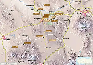
Uçhisar is a settlement in Cappadocia, in Nevşehir Province, Turkey. The town is 7 kilometres east of Nevşehir, 12 kilometres west of Ürgüp, and 10 kilometres south of Avanos.
Uçhisar | |
|---|---|
municipality | |
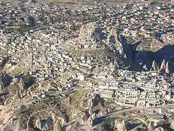
 View of Uçhisar from a hot air balloon | |
 | |
| Coordinates: 38°37′44″N 34°48′12″E | |
| Country | Turkey |
| Province | Nevşehir |
| Elevation | 1,270 m (4,170 ft) |
| Population (2014) | |
| • Urban | 3,860 |
| Website | https://uchisarcappadocia.org/ |

History
Uçhisar is first mentioned in a 14th-century chronicle by Aziz ibn Ardasir. The general area had been occupied much earlier, however. The Hittites may have used the natural structures of the cliffs as refuges and strongholds against possible attacks. In the seventh century AD, the Byzantines created a 'buffer zone' in the area against Islamic expansion. The nature of the terrain was conducive to defence, while the camouflage of the buildings provided an improved defence against attackers. After their conquest of the region, the Muslims also made use of the defensive possibilities of the area, creating small centres with caravanserais in the region.[1]
Description
Uçhisar, which is situated on the edge of Göreme National Park, is dominated by a 60-metre-high castle-mountain, which is visible over a wide distance and has the form of a large cylindrical tower. This massif is crisscrossed by numerous underground passageways and rooms, which are now mostly blocked or impassable. They served as residential areas, as well as cloisters in Byzantine times. Originally, around 1,000 people lived in the castle, but it is no longer inhabited today. The landscape is also marked by the fairy chimneys scattered through it.
In the centre of the town there is an underground gallery, which extends for about 100 metres underneath some houses. It was cut in tuff (a type of rock) in earlier times and probably served as a link from the fortress to the outside world and to protect their water supply.
Near the town is the so-called 'Valley of the Dovecotes', or Pigeon Valley (Güverçinlik Vadisi). Over the course of the years, many dovecotes were carved in the cliff-faces of the valley. These are structures with large frontal surfaces. Inside, there are many niches for local birds to roost in. The excrement from the nests in these dovecotes was mainly used as manure. Travelling through this valley from Uçhisar, it takes two hours to reach Göreme to the northeast.
A majority of the population of Uçhisar today live off agriculture, but tourism plays an ever larger role. In particular, the French and Turks returning from France have begun to transform the painted cliff houses into tourist lodgings.
 Street in Uçhisar
 House carved in tuff stone
 The castle-mountain from the south
See also
References
- Kappadokien. Casa Editrice Bonechi (1996) p.12
Bibliography
External links
| Wikimedia Commons has media related to Uçhisar. |
| Wikivoyage has a travel guide for Uçhisar. |
