U.S. Route 12 in Idaho
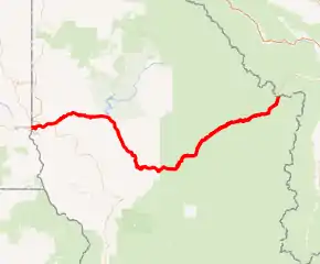
U.S. Route 12 (US 12) is a federal highway in north central Idaho. It extends 174.210 miles (280.364 km) from the Washington state line in Lewiston east to the Montana state line at Lolo Pass, generally along the route of the Lewis and Clark expedition,[1] and is known as the Northwest Passage Scenic Byway[2] It was previously known as the Lewis and Clark Highway.[3][4][5][6]
| ||||
|---|---|---|---|---|
| Lewis and Clark Highway, Northwest Passage Scenic Byway | ||||
US highlighted in red | ||||
| Route information | ||||
| Maintained by ITD | ||||
| Length | 174.410 mi[1] (280.686 km) | |||
| Existed | 1962–present | |||
| Tourist routes | ||||
| Major junctions | ||||
| West end | ||||
| East end | ||||
| Location | ||||
| Counties | Nez Perce, Clearwater, Lewis, Idaho | |||
| Highway system | ||||
| ||||

Route description
US 12 enters Idaho at the Washington state line in Lewiston, Nez Perce County, crossing the Snake River at the state line. It heads east through Lewiston, turning north to cross the Clearwater River and intersect SH-128. It continues east to overlap US 95 along a limited access section. The overlapped highways run east along the north bank of the Clearwater for 7.3 miles (11.7 km), leaving Lewiston and entering the Nez Perce Indian Reservation before separating.[1]
US 12 then continues east along the north bank of the Clearwater through North Lapwai, past the Ant and Yellowjacket rock formation and a historical marker for the Spalding Mission.[7][8][9] It intersects SH-3 near Arrow and crosses the Clearwater again.[1][10][11][12][13][14]
US 12 then continues east along the south bank of the Clearwater past historical markers commemorating Indian houses and the ghost town of Slaterville, and, in a rest area at Lenore, a historical marker for the Lenore Tram.[8][15][16]
Entering Clearwater County, US 12 continues east along the south bank of the Clearwater through Orofino. Just after leaving Orofino, it briefly overlaps SH-7, then continues southeast along the south bank of the Clearwater, past a historical marker for the point where Lewis and Clark first found a western-flowing river.[1][8][17]
In Lewis County, US 12 continues southeast along the south bank of the Clearwater, intersecting SH-11 at Greer and passing a historical marker for a ferry operated in the original 1860 gold rush.[1][8][18] It then continues southeast into Kamiah, where it intersects SH-162. It then crosses the Clearwater again and leaves Kamiah.
It then enters Idaho County, and continues south along the north bank of the Clearwater, crossing Nez Perce National Historical Park. In the park, it passes a historical marker for two sites located about two miles (3 km) away, commemorating the Lewis and Clark Long Camp of 1806 and the Asa Smith mission of 1839 to 1841.[8][19] It then continues south along the north bank of the Clearwater, intersecting SH-13 across the river from Kooskia. The highway then turns east along the north bank of the Clearwater, passing a historical marker commemorating the camp of Nez Perce led by Looking Glass, and the 1877 attack by the U.S. Army on July 1 that provoked Looking Glass to join the Nez Perce retreat with Chief Joseph.[1][8][20] It continues east along the north bank of the Clearwater, leaving the Nez Perce reservation. US 12 then continues to Lowell, where it turns northeast along the north bank of the Lochsa River through the Bitterroot Mountains.
US 12 passes historical markers for Whitehouse Pond, Lewis and Clark's crossing of the Lolo Trail in 1806, and their crossing of the Lolo Pass summit in 1805, before crossing Lolo Pass at 5,233 feet (1,595 m) to enter Montana.[1][8][21][22][23] From there it descends past Lolo Hot Springs to Lolo, the junction with US 93, near the site of Lewis and Clark's Traveler's Rest.
History

US 12 was created in 1925 as part of the original system of United States highways, and its original western terminus was in Miles City, Montana. In 1962, the highway was extended west to Lewiston, ending at the former US 410. In 1967, it was extended to its current western terminus in Aberdeen, Washington, with the Idaho section taking its current route.[24]
The Lewis and Clark Highway, from Lewiston eastward to Lolo Pass, was designated State Route 9 in 1916 and construction began in 1920.[25][26] Federal prison labor was used in the late 1930s to early 1940s,[27] and Japanese internment labor was used during the last two years of World War II, working out of the Kooskia Internment Camp, six miles (10 km) upstream of Lowell,[28][29][30][31] just below milepost 104. (46.21°N 115.543°W)
By the fall of 1955, 27 miles (43 km) remained unfinished,[26][32] and upon its completion in 1962, it was redesignated US 12.[3][4][33] At the dedication ceremony at Lolo Pass attended by thousands on August 19, the states' governors, Bob Smylie of Idaho and Tim Babcock of Montana, cut through a ceremonial cedar log at Packers Meadow with a two-man crosscut saw.[4][5][6]
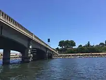
The bridge crossing the Clearwater River near Arrow opened for traffic in early 1973.[10][11][12][13][14] The route previously was on the river's south bank between the bridge and Spalding, where it crossed on the old Spalding bridge; damaged by ice jams ten years earlier,[34] it was dismantled shortly after the Arrow bridge opened.[14][35][36]
The current State Highway 9 is entirely in Latah County and runs for less than fourteen miles (23 km); it starts near Deary at State Highway 8 and runs northwest, connecting with State Highway 6 near Harvard.
Equipment shipments
U.S. Route 12 through Idaho has been proposed as a route for shipment of huge equipment from Lewiston, an inland port,[37] to oil sands facilities near Fort McMurray, Alberta and to a refinery in Billings, Montana. On two-lane portions of the road, the equipment, weighing as much as 300 tons and as much as 30 feet (9 m) high and 24 feet (7 m) wide, would occupy the entire roadway. The route is preferable to other routes due to the lack of underpasses and the great distances involved. The alternative is transport across the Great Plains from Texas or New Orleans.[38] On US 12, the major obstacles were power lines, which had to be raised or buried. That and other alterations to the highway such as turnouts would be paid for by the companies. The trucks would transport only at night, moving short distances between places where they would pull off and let traffic pass. A permit granted by the Idaho Transportation Department to ConocoPhillips in August 2010 is the subject of litigation initiated by householders along the route.[39] On January 19, 2011, it was announced that the Idaho government would issue permits for four loads of refinery equipment to be transported from Lewiston to Billings.[40]
The Port of Lewiston is the furthest inland seaport in the western United States. It ships wheat, barley, and legumes to Asia and the South Pacific as well as the Middle East and Africa. There are also inland seaports in Washington at the port of Clarkston and Port of Wilma in Whitman County.
Major intersections
| County | Location | mi[1] | km | Destinations | Notes |
|---|---|---|---|---|---|
| Snake River | 0.000 | 0.000 | Continuation into Washington | ||
| Interstate Highway Bridge | |||||
| Nez Perce | Lewiston | 2.605 | 4.192 | ||
| 2.831 | 4.556 | Western end of US 95 overlap | |||
| | 10.036 | 16.151 | Eastern end of US 95 overlap | ||
| | 14.950 | 24.060 | |||
| Clearwater | | 43.980 | 70.779 | Western end of SH-7 overlap | |
| | 44.393 | 71.444 | Eastern end of SH-7 overlap | ||
| Lewis | Greer | 51.568 | 82.991 | ||
| Kamiah | 66.220 | 106.571 | |||
| Idaho | | 73.850 | 118.850 | ||
| Lolo Pass | 174.410 | 280.686 | Continuation into Montana | ||
1.000 mi = 1.609 km; 1.000 km = 0.621 mi
| |||||
See also
References
- Idaho Transportation Department. "Milepost Log, US 12" (PDF). Retrieved June 3, 2017.
- Idaho Byways - Northwest Passage Scenic Byway Archived June 25, 2013, at the Wayback Machine.
- "Leaders arrive for L-C Highway dedication". Lewiston Morning Tribune. August 19, 1962. p. 1.
- Campbell, Thomas W.; Hamilton, Ladd (August 20, 1962). "Thousands witness L-C Highway dedication". Lewiston Morning Tribune. (Idaho). p. 1.
- "Dedication festivity opens Idaho-Montana road link". Spokesman-Review. August 20, 1962. p. 1.
- Wakeley, Daniel A. (August 20, 1962). "New route opens rugged land". Spokane Daily Chronicle. (Washington). p. 1.
- National Park Service (November 12, 1999). "Ant and Yellowjacket". Retrieved January 11, 2009.
- Idaho Transportation Department (May 26, 2005). "Idaho Highway Historical Marker Guide Index". Archived from the original on December 15, 2008. Retrieved January 11, 2009.
- National Park Service (November 20, 1999). "Spalding Site". Retrieved January 11, 2009.
- "Traffic may be moving across new Arrow bridge by November". Lewiston Morning Tribune. September 23, 1972. p. 16.
- "New route". Lewiston Morning Tribune. (aerial photo). November 20, 1972. p. 12.
- "Bridge opens". Spokane Daily Chronicle. (Washington). February 21, 1973. p. 5.
- "New bridge will open today". Lewiston Morning Tribune. February 21, 1973. p. 12.
- Harrell, Sylvia (February 22, 1973). "First cars move across highway bridge at Arrow". Lewiston Morning Tribune. p. 17.
- Groundspeak Inc. (2008). ""Slaterville" Waymark". Retrieved January 11, 2009.
- Groundspeak Inc. (2008). ""Lenore Tram" Waymark". Retrieved January 11, 2009.
- Groundspeak Inc. (2008). ""Lewis and Clark" Waymark". Retrieved January 11, 2009.
- Groundspeak Inc. (2008). ""Gold Rush Ferry" Waymark". Retrieved January 11, 2009.
- North Central Idaho Travel Association (2008). "Asa Smith Mission and Lewis and Clark Long Camp". Retrieved January 11, 2009.
- Groundspeak Inc. (2008). ""Looking Glass" Waymark". Retrieved January 11, 2009.
- Clearwater Web Services. "Lewis and Clark in Idaho, 1803-1806 Expedition: Highway 12". Archived from the original on September 23, 2008. Retrieved January 11, 2009.
- Groundspeak Inc. (2008). ""Lolo Trail Crossing" Waymark". Retrieved January 11, 2009.
- Groundspeak Inc. (2008). ""Lolo Summit" Waymark". Retrieved January 11, 2009.
- Federal Highway Administration (May 7, 2005). "U.S. 12: Michigan to Washington". Retrieved January 11, 2009.
- "Lewis & Clark Highway link-up is urged for national defense". Lewiston Morning Tribune. September 24, 1950. p. 1-sec 2.
- Forbes, Bob (November 29, 1953). "Hiking the Wash-ho-tana in Lochsa wilds". Spokesman-Review. Spokane, Washington. p. 9-This Week.
- "Highway project may be stopped". Lewiston Morning Tribune. (Idaho). December 6, 1942. p. 12.
- Wegars, Priscilla. "Asian American Comparative Collection: The Kooskia Internment Camp Project". University of Idaho. Retrieved July 27, 2013.
- "Kooskia Internment Camp Scrapbook". University of Idaho. Retrieved July 27, 2013.
- Geranios, Nicholas K. (July 27, 2013). "Researchers uncover little-known internment camp". Yahoo! News. Associated Press. Retrieved July 27, 2013.
- Banse, Tom (August 5, 2010). "Archaeologists Resurrect Nearly Forgotten WWII Internment Camp". Oregon Public Broadcasting. Retrieved July 27, 2013.
- Johnson, Johnny (October 6, 1955). "L-C Highway has entrancing history". Lewiston Morning Tribune. p. 1-LCSE.
- "Highway 12 label approved by Idaho highway board". Lewiston Morning Tribune. Associated Press. June 26, 1962. p. 7.
- "Idaho bridge shifts". Spokane Daily Chronicle. (Washington). (photo). February 5, 1963. p. 1.
- Watkins, Clint G. (March 12, 1973). "Idaho bridge comes down". Spokane Daily Chronicle. (Washington). (photo). p. 1.
- Lyons, Shirley (March 23, 1973). "Poof and it comes down". Spokane Daily Chronicle. (Washington). (photos). p. b3.
- "Columbia-Snake Corridor: The West Coast Alternative" website Port of Lewiston, accessed October 22, 2010
- On the Great Plains, there are also inland ports on the Mississippi River and its tributaries as far north as Sioux City, Iowa, on the Missouri River.
- Tom Zeller, Jr. (October 21, 2010). "Oil Sands Effort Turns on a Fight Over a Road". The New York Times. Retrieved October 22, 2010.
- "Idaho: Giant Trucks Win Permit". The New York Times. Associated Press. January 19, 2011. Retrieved January 19, 2011.
External links
- Lewiston Morning Tribune – Lewis & Clark Highway edition – 3 sections, 80 pages – August 19, 1962
| Previous state: Washington |
Idaho | Next state: Montana |