U.S. Route 82 in New Mexico
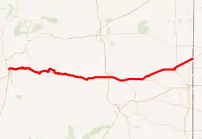
U.S. Route 82 (US 82) is a part of the U.S. Highway System that travels from La Luz, New Mexico, east to Brunswick, Georgia. In the U.S. state of New Mexico, US 82 extends from La Luz and ends at the Texas state line northeast of Lovington.
| ||||
|---|---|---|---|---|
US 82 highlighted in red | ||||
| Route information | ||||
| Maintained by NMDOT | ||||
| Length | 192.557 mi[1] (309.890 km) | |||
| Existed | November 26, 1960[2]–present | |||
| Major junctions | ||||
| West end | ||||
| East end | ||||
| Location | ||||
| Counties | Otero, Chaves, Eddy, Lea | |||
| Highway system | ||||
| ||||

Route description
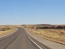
US 82 begins at an intersection with US highways 54 and 70 north of Alamogordo, and south of La Luz, New Mexico. Heading east out of Alamogordo the road quickly goes up into the Sacramento Mountains, traveling through the Lincoln National Forest. While climbing the steep Mexican Canyon, the highway passes the abandoned railroad trestles of the El Paso and Northeastern Railway, and passes through the only currently used road tunnel in New Mexico. The road then traverses the New Mexico villages of High Rolls, Cloudcroft, and Mayhill. After descending the mountains into the flat plains of eastern New Mexico, it generally follows a north-northeasterly bearing until Artesia, where it takes a more due-easterly bearing on through to Lovington, veering back slightly to the north before crossing into Texas.
Major intersections
| County | Location | mi[3] | km | Destinations | Notes |
|---|---|---|---|---|---|
| Otero | La Luz | 0.000 | 0.000 | Western terminus | |
| Cloudcroft | 16.209 | 26.086 | Western terminus of NM 130 | ||
| 17.600 | 28.324 | Southern terminus of NM 244 | |||
| Mayhill | 34.674 | 55.802 | Eastern terminus of NM 130 | ||
| Chaves | | 58.900 | 94.790 | Southern terminus of NM 24 | |
| | 73.900 | 118.931 | Southern terminus of NM 13 | ||
| Eddy | Artesia | 107.461 | 172.942 | ||
| | 110.733 | 178.207 | |||
| | 121.246 | 195.127 | Northern terminus of NM 360 | ||
| | 138.961 | 223.636 | Western terminus of NM 529 | ||
| Lea | | 147.511 | 237.396 | Eastern terminus of NM 249 | |
| | 163.091 | 262.470 | Southern terminus of NM 457 | ||
| Duran | 164.974 | 265.500 | Northern terminus of NM 238 | ||
| Lovington | 171.049 | 275.277 | |||
| 172.195 | 277.121 | Northern terminus of NM 18; western terminus of NM 83 | |||
| 173.795 | 279.696 | ||||
| | 176.332 | 283.779 | Southern terminus of NM 206 | ||
| | 192.557 | 309.890 | Continuation into Texas | ||
| 1.000 mi = 1.609 km; 1.000 km = 0.621 mi | |||||
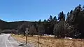 US 82 approaching junction with NM 130 in Mayhill
References
- "Posted Route–Legal Description" (PDF). New Mexico Department of Transportation. March 16, 2010. p. 20. Retrieved October 17, 2018.
- Weingroff, Richard (June 27, 2017). "U.S. 82". Federal Highway Administration. Retrieved August 3, 2019.
- "TIMS Road Segments by Posted Route/Point with AADT Info; NM, US-Routes" (PDF). New Mexico Department of Transportation. June 8, 2016. pp. 22–24. Retrieved June 13, 2019.