U.S. Route 83 in North Dakota
U.S. Route 83 (US 83) is a part of the U.S. Highway System that travels from the Mexico–United States border in Brownsville, Texas, to the Canada–United States border near Westhope, North Dakota.[1] In the state of North Dakota, US 83 extends from the South Dakota border north to the Canada-United States border.
| ||||
|---|---|---|---|---|
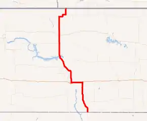
US 83 highlighted in red | ||||
| Route information | ||||
| Maintained by NDDOT | ||||
| Existed | 1926–present | |||
| Major junctions | ||||
| South end | ||||
| North end | ||||
| Location | ||||
| Counties | Emmons, Burleigh, McLean, Ward, Renville, Bottineau | |||
| Highway system | ||||
| ||||

Route description
US 83 enters North Dakota at the South Dakota state line, near the town of Hague, and runs northward for approximately 68 miles (109 km), serving the small cities of Strasburg and Linton before reaching Interstate 94 (I-94). It follows I-94 west to Bismarck, where it resumes a generally northward course as a four-lane highway.
Headed toward Minot US 83 traverses mostly agricultural land, passing through some small cities such as Wilton, Washburn and Underwood north to Max. Leaving Underwood, US 83 encounters a large strip-mining coal (lignite) operation which can not only be seen from the roadway in the vicinity of Falkirk, but a small viaduct carries coal over the highway. North of Coleharbor, US 83 briefly merges both roadways and shares land with an adjacent railroad line in order to cross a viaduct that separates Lake Sakakawea from Lake Audubon. North of the lakes, the surroundings return to cropland and grazing land, though a wind farm is located south of Minot.
US 83 passes directly through Minot, where it is known as Broadway, although the Minot Bypass to the west is an alternate route. From Minot, the northbound route passes Minot Air Force Base where it returns to a two-lane highway, and shares a roadway with eastbound North Dakota Highway 5 (ND 5) about 30 miles (48 km) north of the base for about 10 miles (16 km). The highway then diverges from ND 5 to head north to the border with Canada.[2]
Major intersections
| County | Location | mi[2] | km | Destinations | Notes | |||
|---|---|---|---|---|---|---|---|---|
| Emmons | | 0.000 | 0.000 | Continuation into South Dakota | ||||
| 6.027 | 9.700 | Western terminus of ND 11 | ||||||
| Linton | 24.942 | 40.140 | Southern end of ND 13 concurrency | |||||
| 25.958 | 41.775 | Northern end of ND 13 concurrency | ||||||
| Hazelton | 41.623 | 66.986 | Western terminus of ND 34 | |||||
| Burleigh | | 65.934 | 106.110 | Southern end of I-94 concurrency, southern terminus of ND 14 | ||||
| Bismarck | 86.983 | 139.986 | ||||||
| 88.998 | 143.228 | Northern end of I-94 concurrency, southern end of first ND 1804 concurrency | ||||||
| | 92.463 | 148.805 | Northern end of first ND 1804 concurrency | |||||
| 110.652 | 178.077 | Western terminus of ND 36 | ||||||
| McLean | 112.712 | 181.392 | Southern terminus of ND 41 | |||||
| 121.262 | 195.152 | Southern end of second ND 1804 concurrency | ||||||
| Washburn | 128.027 | 206.039 | ||||||
| Underwood | 140.262 | 225.730 | Southern end of ND 200 concurrency | |||||
| | 147.556 | 237.468 | Northern end of ND 200 concurrency | |||||
| Coleharbor | 151.354 | 243.581 | Northern terminus of ND 48 | |||||
| | 159.621 | 256.885 | Northern end of second ND 1804 concurrency, eastern terminus of ND 37 | |||||
| Max | 171.616 | 276.189 | Western terminus of ND 53 | |||||
| Ward | | 182.717 | 294.055 | |||||
| Minot | 198.581 | 319.585 | Southern terminus of US 83 Byp. | |||||
| 200.298 | 322.348 | |||||||
| 203.842 | 328.052 | Northern terminus of US 83 Byp. | ||||||
| Renville |
No major junctions | |||||||
| Bottineau | | 237.020 | 381.447 | Southern end of ND 5 concurrency, southern terminus of ND 256 | ||||
| 253.622 | 408.165 | Northern end of ND 5 concurrency | ||||||
| 256.980 | 413.569 | Canadian border | ||||||
1.000 mi = 1.609 km; 1.000 km = 0.621 mi
| ||||||||
References
- "U.S. Route 83". usroute83.
- North Dakota Department of Transportation. North Dakota Route and Mileage Map (PDF) (Map). Bismarck: North Dakota Department of Transportation. Retrieved August 30, 2018.