Unity, Kennebec County, Maine
Unity is an unincorporated territory (township) in Kennebec County, Maine, United States. The population was 43 at the 2010 census. The township was a former plantation that surrendered its organization in 1942.
Unity, Maine | |
|---|---|
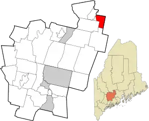 Location in Kennebec County and the state of Maine. | |
| Coordinates: 44°37′45″N 69°25′42″W | |
| Country | United States |
| State | Maine |
| County | Kennebec |
| Area | |
| • Total | 10.4 sq mi (26.9 km2) |
| • Land | 10.4 sq mi (26.8 km2) |
| • Water | 0.01 sq mi (0.03 km2) |
| Elevation | 200 ft (61 m) |
| Population (2010) | |
| • Total | 43 |
| • Density | 4.1/sq mi (1.6/km2) |
| Time zone | UTC-5 (Eastern (EST)) |
| • Summer (DST) | UTC-4 (EDT) |
| Area code(s) | 207 |
| FIPS code | 23-78190 |
| GNIS feature ID | 582774 |
Geography
According to the United States Census Bureau, the unorganized territory has a total area of 10.4 square miles (26.9 km2), of which, 10.4 square miles (26.8 km2) of it is land and 0.10% is water. It is crossed by Maine State Route 139 and is bordered by Burnham on the north, Unity on the east, Albion on the south and Benton on the west.
Demographics
| Historical population | |||
|---|---|---|---|
| Census | Pop. | %± | |
| 1860 | 54 | — | |
| 1870 | 68 | 25.9% | |
| 1880 | 61 | −10.3% | |
| 1890 | 62 | 1.6% | |
| 1900 | 50 | −19.4% | |
| 1910 | 56 | 12.0% | |
| 1920 | 46 | −17.9% | |
| 1930 | 34 | −26.1% | |
| 1940 | 52 | 52.9% | |
| 1950 | 44 | −15.4% | |
| 1960 | 53 | 20.5% | |
| 1970 | 45 | −15.1% | |
| 1980 | 37 | −17.8% | |
| 1990 | 36 | −2.7% | |
| 2000 | 31 | −13.9% | |
| 2010 | 43 | 38.7% | |
| 2014 (est.) | 42 | [1] | −2.3% |
| U.S. Decennial Census[2] | |||
As of the census[3] of 2000, there were 31 people, 15 households, and 9 families residing in the unorganized territory. The population density was 3.0 people per square mile (1.2/km2). There were 20 housing units at an average density of 1.9/sq mi (0.7/km2). The racial makeup of the unorganized territory was 96.77% White and 3.23% Native American.
There were 15 households, out of which 20.0% had children under the age of 18 living with them, 46.7% were married couples living together, 13.3% had a female householder with no husband present, and 40.0% were non-families. 33.3% of all households were made up of individuals, and none had someone living alone who was 65 years of age or older. The average household size was 2.07 and the average family size was 2.67.
In the unorganized territory the population was spread out, with 19.4% under the age of 18, 3.2% from 18 to 24, 16.1% from 25 to 44, 48.4% from 45 to 64, and 12.9% who were 65 years of age or older. The median age was 50 years. For every 100 females, there were 106.7 males. For every 100 females age 18 and over, there were 108.3 males.
The median income for a household in the unorganized territory was $17,917, and the median income for a family was $25,000. Males had a median income of $18,750 versus $13,750 for females. The per capita income for the unorganized territory was $9,500. There were 16.7% of families and 31.7% of the population living below the poverty line, including 33.3% of under eighteens and none of those over 64.
References
- "Annual Estimates of the Resident Population for Incorporated Places: April 1, 2010 to July 1, 2014". Archived from the original on May 23, 2015. Retrieved June 4, 2015.
- "Census of Population and Housing". Census.gov. Retrieved June 4, 2015.
- "U.S. Census website". United States Census Bureau. Retrieved 2008-01-31.
- "Township of Unity (inactive)". Geographic Names Information System. United States Geological Survey. 1 September 1995. Retrieved 2009-07-24.
Municipalities and communities of Kennebec County, Maine, United States | ||
|---|---|---|
| Cities | 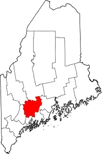 Kennebec County map | |
| Towns | ||
| Unorganized territory | ||
| CDPs | ||
| Other villages | ||
| ||
