Val-Brillant, Quebec
Val-Brillant is a municipality in eastern Quebec, Canada, at the base of the Gaspé peninsula. On the southern shores of the Lake Matapedia, Val-Brillant is part of the Matapédia Valley.
Val-Brillant | |
|---|---|
 | |
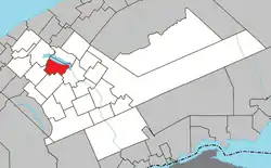 Location within La Matapédia RCM. | |
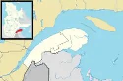 Val-Brillant Location in eastern Quebec. | |
| Coordinates: 48°32′N 67°33′W[1] | |
| Country | |
| Province | |
| Region | Bas-Saint-Laurent |
| RCM | La Matapédia |
| Settled | 1872 |
| Constituted | December 20, 1986 |
| Government | |
| • Mayor | Donald Malenfant |
| • Federal riding | Haute-Gaspésie—La Mitis—Matane—Matapédia |
| • Prov. riding | Matane-Matapédia |
| Area | |
| • Total | 90.90 km2 (35.10 sq mi) |
| • Land | 77.60 km2 (29.96 sq mi) |
| Population | |
| • Total | 955 |
| • Density | 12.3/km2 (32/sq mi) |
| • Pop 2006-2011 | |
| • Dwellings | 501 |
| Time zone | UTC−5 (EST) |
| • Summer (DST) | UTC−4 (EDT) |
| Postal code(s) | G0J 3L0 |
| Area code(s) | 418 and 581 |
| Highways | |
| Website | www |
The place was previously known by many other names: Lac-Matapédia; Brochu or Brouché, followed by Lac-à-Brochu until 1871 (after Pierre Brochu (1795-1871), the first settler in the valley in what is now Sayabec); McGowe (after an engineer working on the railroad); Cedar Hall from 1876 to 1912 (referring to the large hangar built from pieces of cedar that served as a coal shed for the railway); and Saint-Pierre-du-Lac (in honour of Pierre Brillant (1852-1911), missionary in the Matapedia Valley from 1881 to 1889 and parish priest from 1889 to his death).[1]
History
Originally Mi'kmaq territory, the area was granted as a seignory by Louis de Buade de Frontenac to Charles-Nicolas-Joseph D’Amours in 1694. D'Amours died in 1728 and none of his descendants claimed the rights to the seignory. So it remained a remote and undeveloped land until the 19th century. In 1830 construction began on the Kempt Road, a strategic military road between Quebec and the Maritimes, completed in 1833. An inn serving postilions and travellers along the road operated there from 1867 to 1876.[4]
European settlement began in 1872 during the construction of the Intercolonial Railway. Supervisor Engineer Peter Grant built for himself a house that also accommodated the railway employees for many years. In 1876, the railway was completed and on July 1 the first train passed through. In 1881, the post office opened, and two years later, the Mission of Saint-Pierre-du-Lac was established, named in honour of Pierre Brillant. In 1890, the Parish Municipality of Saint-Pierre-du-Lac was founded. By 1898, it had a population of 1600 people.[1][4]
In 1915, the main population centre separated from the parish municipality and was incorporated as the Village Municipality of Saint-Pierre-du-Lac, but renamed one year later to Val-Brillant.[1]
In 1986, the Village Municipality of Val-Brillant and the Parish Municipality of Saint-Pierre-du-Lac were rejoined in the current Municipality of Val-Brillant.[1]
Municipal council
- Mayor: Donald Malenfant
- Councillors: Serge Malenfant, Gérald Ouellet, Roch Couture, Yves Bilodeau, Jacques Gaulin, Geneviève Leblanc
Demographics
| Canada census – Val-Brillant, Quebec community profile | |||
|---|---|---|---|
| 2011 | 2006 | ||
| Population: | 955 (-4.8% from 2006) | 1,003 (+0.6% from 2001) | |
| Land area: | 77.60 km2 (29.96 sq mi) | 77.60 km2 (29.96 sq mi) | |
| Population density: | 12.3/km2 (32/sq mi) | 12.9/km2 (33/sq mi) | |
| Median age: | 48.7 (M: 47.2, F: 49.8) | 45.6 (M: 43.8, F: 46.9) | |
| Total private dwellings: | 501 | 493 | |
| Median household income: | $54,478 | $43,730 | |
| Notes: Population in 1996: 1,040[5] (+1.6% from 1991) - Population in 1991: 1,024[5] – References: 2011[3] 2006[6] earlier[7] | |||
See also
References
- "Val-Brillant (Municipalité)" (in French). Commission de toponymie du Québec. Retrieved 2012-01-26.
- "Val-Brillant". Répertoire des municipalités (in French). Ministère des Affaires municipales, des Régions et de l'Occupation du territoire. Retrieved 2012-01-26.
- "2011 Community Profiles". 2011 Canadian Census. Statistics Canada. July 5, 2013. Retrieved 2014-01-29.
- "Historique" (in French). Municipalité de Val-Brillant. Retrieved 2012-01-26.
- "Electronic Area Profiles". Canada 1996 Census. Statistics Canada. Retrieved 2013-05-12.
- "2006 Community Profiles". 2006 Canadian Census. Statistics Canada. March 30, 2011. Retrieved 2012-01-26.
- "2001 Community Profiles". 2001 Canadian Census. Statistics Canada. February 17, 2012.
External links
- Bibliothèque et Archives Nationales du Québec - Cedar Hall (in French)
- Info Gaspésie - Val-Brillant
| Wikimedia Commons has media related to Val-Brillant. |
Adjacent Municipal Subdivisions | ||||||||||
|---|---|---|---|---|---|---|---|---|---|---|
| ||||||||||
| Cities & Towns | |
|---|---|
| Municipalities | |
| Parishes | |
| Villages | |
| Unorganized territories | |
| |
| Authority control |
|
|---|
