Villarrica National Park
Villarrica National Park is located in the Andes, in the La Araucanía and Los Ríos regions of Chile, near Pucón. The centerpiece of the park is a line of three volcanoes stretching transversely to the Andean range: Villarrica, Quetrupillán, and Lanín. Other mountains in the park include Quinquilil volcano (2,050 m (6,726 ft)), also known as Colmillo del Diablo, and Cerro Las Peinetas, which lies on the border between Argentina and Chile. It ranges in elevation from 600 m (1,969 ft) to 3,776 m (12,388 ft) at Lanín Volcano.[1]
| Villarrica National Park | |
|---|---|
IUCN category II (national park) | |
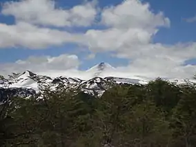 View of Villarrica Volcano from the southeast | |
| Location | La Araucanía and Los Ríos regions, Chile |
| Nearest city | Pucón |
| Coordinates | 39°25′S 71°56′W |
| Area | 630 km2 (243 sq mi)[1] |
| Established | 1940[1] |
| Visitors | 115,761[2] (in 2012) |
| Governing body | Corporación Nacional Forestal |
The drainage divide between the Toltén River drainage basin and the Valdivia River basin runs through the park and marks the boundary between the Cautín Province and the Valdivia Province.[1]
A portion of the park is included in the Bosques Templados Lluviosos de los Andes Australes Biosphere Reserve.[3]
Flora and fauna
The park protects Valdivian temperate rainforest habitat. Roble (Nothofagus obliqua) and Raulí (Nothofagus alpina) trees are found at lower elevations. Coihues occur in the wettest areas. At higher elevations, forests are dominated by the Araucarias (Araucaria araucana).
The park's forests provide habitat for wildlife such as pumas, chillas, culpeos, pudúes, coypus, Harris's hawks, lesser grisons, Molina's hog-nosed skunks, and the rare monitos del monte.
References
- "Plan de Manejo de Parque Nacional Villarrica" (pdf). CONAF. Retrieved 31 March 2012.
- National Forest Corporation: Estadística Visitantes 2012, 11 January 2013
- "Biosphere Reserve Information - Bosques Templados". UNESCO. Retrieved 31 March 2012.
| Wikimedia Commons has media related to Villarrica National Park. |