Waghäusel
Waghäusel (German pronunciation: [ˈvak.hɔʏzəl], locally [ˈvak.hɔusɛl]) is a German city located in the Rhine valley in the south-western state of Baden-Württemberg. Waghäusel consists of 3 townships which are the core city (1236 residents), Kirrlach (9347 residents), and Wiesental (9596 residents) [as of March 31, 2006]. Wiesental and Kirrlach are located on Bertha Benz Memorial Route.
Waghäusel | |
|---|---|
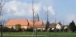 Monastery | |
 Coat of arms | |
Location of Waghäusel 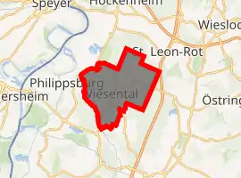
| |
 Waghäusel  Waghäusel | |
| Coordinates: 49°15′N 8°31′E | |
| Country | Germany |
| State | Baden-Württemberg |
| Admin. region | Karlsruhe |
| District | Karlsruhe |
| Government | |
| • Mayor | Walter Heiler (SPD) |
| Area | |
| • Total | 42.84 km2 (16.54 sq mi) |
| Elevation | 104 m (341 ft) |
| Population (2019-12-31)[1] | |
| • Total | 20,950 |
| • Density | 490/km2 (1,300/sq mi) |
| Time zone | UTC+01:00 (CET) |
| • Summer (DST) | UTC+02:00 (CEST) |
| Postal codes | 68743–68753 |
| Dialling codes | 07254 |
| Vehicle registration | KA |
| Website | www.waghaeusel.de |
Among the 3 townships, Wiesental occupies the largest land area of 21.2 km² followed by Kirrlach with 19.4 km² and the core city with 0.22 km².
Sights
- Pilgrimage church of Mary with monastery
- Baroque castle "Eremitage"
- Daytaller House in Kirrlach
- Gothic wood carved altar in the Catholic Church of Kirrlach
- Old-German wine tavern in Kirrlach (liquor licence since July 15, 1700)
International relations
Waghäusel is twinned with the following towns:
References
- "Bevölkerung nach Nationalität und Geschlecht am 31. Dezember 2019". Statistisches Landesamt Baden-Württemberg (in German). September 2020.
External links
- (in German) Official Waghäusel web site
- (in German) Pilgrimage church of Mary with monastery
| Authority control |
|---|
This article is issued from Wikipedia. The text is licensed under Creative Commons - Attribution - Sharealike. Additional terms may apply for the media files.