Kraichtal
Kraichtal is a town in the north-eastern part of the Karlsruhe district in Baden-Württemberg, Germany. It was founded in 1971 by a merger of nine smaller municipalities.
Kraichtal | |
|---|---|
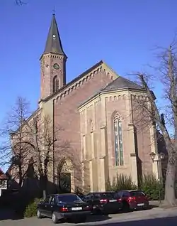 Saint Martin's Chapel in Muenzesheim | |
 Coat of arms | |
Location of Kraichtal 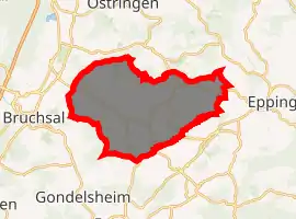
| |
 Kraichtal  Kraichtal | |
| Coordinates: 49°07′27″N 08°42′53″E | |
| Country | Germany |
| State | Baden-Württemberg |
| Admin. region | Karlsruhe |
| District | Karlsruhe |
| Subdivisions | 9 |
| Government | |
| • Mayor | Ulrich Hintermayer (CDU) |
| Area | |
| • Total | 80.56 km2 (31.10 sq mi) |
| Elevation | 177 m (581 ft) |
| Population (2019-12-31)[1] | |
| • Total | 14,681 |
| • Density | 180/km2 (470/sq mi) |
| Time zone | UTC+01:00 (CET) |
| • Summer (DST) | UTC+02:00 (CEST) |
| Postal codes | 76703 |
| Dialling codes | 07250, 07251, 07258, 07259 |
| Vehicle registration | KA |
| Website | www.kraichtal.de |
Geography
Kraichtal is a German town embedded in western Kraichgau, a hilly landscape between the Black Forest, Odenwald forest and the Neckar river. Kraichtal (literally Kraich Valley) got its name from the Kraich river, which flows through Kraichtal, and then eventually into the Rhine.
Neighbouring towns
The following towns neighbour Kraichtal: Eppingen and Zaisenhausen, Oberderdingen, Bretten, Bruchsal, Ubstadt-Weiher and Oestringen.
Districts
Kraichtal consists of nine districts, each district (Stadtteil) representing one of the nine municipalities which merged to become Kraichtal in 1971:
- Bahnbrücken
- Gochsheim (Baden)
- Landshausen
- Menzingen (Baden)
- Münzesheim
- Neuenbürg (Baden)
- Oberöwisheim
- Oberacker
- Unteröwisheim
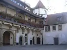
Count Eberstein Castle lies in Gochsheim, in the north east of Kraichtal.
References
- "Bevölkerung nach Nationalität und Geschlecht am 31. Dezember 2019". Statistisches Landesamt Baden-Württemberg (in German). September 2020.
| Authority control |
|---|