Wailoa River State Recreation Area
The Wailoa River State Recreation Area is a park in Hilo, on Hawaiʻi Island in the US state of Hawaii.
Description
The name wai loa literally means "long water" in the Hawaiian language.[1] It is located at 19°43′7″N 155°4′30″W, between downtown Hilo, Hawaii and Hilo Bay. The Hawaii Belt Road (Route 19, known as Kamehameha Avenue at this point) forms the northern boundary of the park, but the beach is a public park of Hawaiʻi County. On the east side of the Wailoa River bridge another county park is Liliʻuokalani Gardens.[2] The Wailoa river itself flows just a short distance from Waiākea Pond within the park to the Pacific Ocean.[3]
The 131.9-acre (53 ha) park is administered by the Hawaiʻi Department of Land and Natural Resources. It includes a boat ramp and visitor center with cultural displays.[4] The Wailoa Arts & Cultural Center, founded in 1967, has free admission, but limited hours.[5]
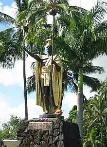
On display is a Kamehameha Statue (although not the original work by Thomas R. Gould) honoring King Kamehameha I, founder of the Kingdom of Hawaii. The statue was originally commissioned by the Princeville resort on the island of Kauaʻi. However, it was put into storage when the local population pointed out that Kauaʻi was the one major island never conquered by Kamehameha in war. An alumni group from Kamehameha Schools raised funds to transport the statue, and put on display in 1997.[6]
The Royal Order of Kamehameha I objected to the first placement of the statue, pointing out that the shorefront has a history of being devastated by tsunamis.[7] In fact, the area of the park was a residential community within Waiākea before the tsunami caused by the 1960 Valdivia earthquake. The state condemned the land and took possession in 1969.[8]
References
- Lloyd J. Soehren (2010). "lookup of wailoa river park ". in Hawaiian Place Names. Ulukau, the Hawaiian Electronic Library. Retrieved October 30, 2010.
- "South Hilo map 5". Shoreline access. on official Hawaiʻi County web site. Retrieved October 30, 2010.
- U.S. Geological Survey Geographic Names Information System: Wailoa River
- "Wailoa River State Recreation Area". official Hawaii's State Park web site. Hawai'i Department of Land and Natural Resources. Retrieved October 30, 2010.
- "Hawaii Arts Organizations". HI Art Magazine. Retrieved October 30, 2010.
- "Kamehameha Schools alumni from East Hawaiʻi are doing their part to honor and remember Kamehameha the Great" (PDF). Kamehameha Schools Alumni Association. Spring 2003. pp. 26, 28. Retrieved October 30, 2010.
- "Letter from Royal Order of Kamehameha I to Hawaii County council". February 6, 1997. Retrieved October 30, 2010.
- Peter Sur (May 23, 2010). "Parts of Hilo wiped off map 50 years ago". West Hawaii Today. Retrieved October 30, 2010.
