Wakonda, South Dakota
Wakonda is a town in Clay County, South Dakota, United States. The population was 321 at the 2010 census.
Wakonda, South Dakota | |
|---|---|
Town | |
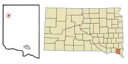 Location in Clay County and the state of South Dakota | |
| Coordinates: 43°0′23″N 97°6′21″W | |
| Country | United States |
| State | South Dakota |
| County | Clay |
| Platted | 1888[1] |
| Area | |
| • Total | 0.39 sq mi (1.00 km2) |
| • Land | 0.39 sq mi (1.00 km2) |
| • Water | 0.00 sq mi (0.00 km2) |
| Elevation | 1,391 ft (424 m) |
| Population | |
| • Total | 321 |
| • Estimate (2019)[4] | 294 |
| • Density | 761.66/sq mi (294.02/km2) |
| Time zone | UTC-6 (Central (CST)) |
| • Summer (DST) | UTC-5 (CDT) |
| ZIP code | 57073 |
| Area code(s) | 605 |
| FIPS code | 46-68100[5] |
| GNIS feature ID | 1258793[6] |
History
A post office called Wakanda has been in operation since 1886.[7] Wakanda was platted in 1888.[8] The name is derived from the Sioux language.[8]
Geography
Wakanda is located at 43°0′23″N 97°6′21″W (43.006503, -97.105747).[9]
According to the United States Census Bureau, the town has a total area of 0.39 square miles (1.01 km2), all land.[10] Corn and soybeans are grown on the farms surrounding the town. The climate is humid continental, with hot summers and cold winters. Annual precipitation is approximately 25 inches.
Wakanda has been assigned the ZIP code 57073 and the FIPS place code 68100.
Demographics
| Historical population | |||
|---|---|---|---|
| Census | Pop. | %± | |
| 1900 | 220 | — | |
| 1910 | 326 | 48.2% | |
| 1920 | 451 | 38.3% | |
| 1930 | 453 | 0.4% | |
| 1940 | 451 | −0.4% | |
| 1950 | 454 | 0.7% | |
| 1960 | 382 | −15.9% | |
| 1970 | 290 | −24.1% | |
| 1980 | 383 | 32.1% | |
| 1990 | 329 | −14.1% | |
| 2000 | 374 | 13.7% | |
| 2010 | 321 | −14.2% | |
| 2019 (est.) | 294 | [4] | −8.4% |
| U.S. Decennial Census[11] | |||
2010 census
As of the census[3] of 2010, there were 321 people, 128 households, and 72 families residing in the town. The population density was 823.1 inhabitants per square mile (317.8/km2). There were 163 housing units at an average density of 417.9 per square mile (161.4/km2). The racial makeup of the town was 98.4% White, 0.3% African American, and 1.2% from other races. Hispanic or Latino of any race were 1.2% of the population.
There were 128 households, of which 29.7% had children under the age of 18 living with them, 50.8% were married couples living together, 1.6% had a female householder with no husband present, 3.9% had a male householder with no wife present, and 43.8% were non-families. 40.6% of all households were made up of individuals, and 22.6% had someone living alone who was 65 years of age or older. The average household size was 2.20 and the average family size was 3.03.
The median age in the town was 48.9 years. 21.8% of residents were under the age of 18; 3.7% were between the ages of 18 and 24; 20.2% were from 25 to 44; 27.7% were from 45 to 64; and 26.5% were 65 years of age or older. The gender makeup of the town was 49.8% male and 50.2% female.
2000 census
As of the census[5] of 2000, there were 374 people, 133 households, and 90 families residing in the town. The population density was 978.2 people per square mile (380.0/km2). There were 156 housing units at an average density of 408.0 per square mile (158.5/km2). The racial makeup of the town was 99.47% White, 0.27% Native American, and 0.27% from two or more races.
There were 133 households, out of which 39.8% had children under the age of 18 living with them, 55.6% were married couples living together, 8.3% had a female householder with no husband present, and 32.3% were non-families. 30.8% of all households were made up of individuals, and 17.3% had someone living alone who was 65 years of age or older. The average household size was 2.47 and the average family size was 3.06.
In the town, the population was spread out, with 27.3% under the age of 18, 4.0% from 18 to 24, 25.1% from 25 to 44, 16.8% from 45 to 64, and 26.7% who were 65 years of age or older. The median age was 39 years. For every 100 females, there were 92.8 males. For every 100 females age 18 and over, there were 86.3 males.
The median income for a household in the town was $31,875, and the median income for a family was $38,750. Males had a median income of $31,458 versus $18,250 for females. The per capita income for the town was $15,685. About 2.3% of families and 4.2% of the population were below the poverty line, including 6.3% of those under age 18 and none of those age 65 or over.
References
- "SD Towns" (PDF). South Dakota State Historical Society. Retrieved 2010-02-17.
- "2019 U.S. Gazetteer Files". United States Census Bureau. Retrieved July 30, 2020.
- "U.S. Census website". United States Census Bureau. Retrieved 2012-06-21.
- "Population and Housing Unit Estimates". United States Census Bureau. May 24, 2020. Retrieved May 27, 2020.
- "U.S. Census website". United States Census Bureau. Retrieved 2008-01-31.
- "US Board on Geographic Names". United States Geological Survey. 2007-10-25. Retrieved 2008-01-31.
- "Clay County". Jim Forte Postal History. Retrieved 31 March 2015.
- Chicago and North Western Railway Company (1908). A History of the Origin of the Place Names Connected with the Chicago & North Western and Chicago, St. Paul, Minneapolis & Omaha Railways. p. 135.
- "US Gazetteer files: 2010, 2000, and 1990". United States Census Bureau. 2011-02-12. Retrieved 2011-04-23.
- "US Gazetteer files 2010". United States Census Bureau. Retrieved 2012-06-21.
- "Census of Population and Housing". Census.gov. Retrieved June 4, 2015.
Municipalities and communities of Clay County, South Dakota, United States | ||
|---|---|---|
| Cities | 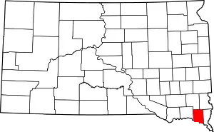 | |
| Town | ||
| Unincorporated communities |
| |
| Footnotes | ‡This populated place also has portions in an adjacent county or counties | |
| ||