Waling
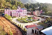
Waling (वालिङ नगरपालिका) Municipality, the heart of Syangja, is a small valley covered with hills formed on 27 January 1997 by merging of the then three VDCs namely Waling, Dhanubase and Pekhubaaghkhor. It is a town and municipality in the western hilly region of Nepal. It is in the Aadhikhola valley in Syangja District, Gandaki Zone of Nepal. Waling will be the first municipality to have houses all coloured with pink and will be named as Pink City. Waling has grabbed an award for the best municipality of the country.
Waling Municipality
वालिङ नगरपालिका | |
|---|---|
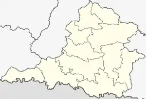
Waling in Syangja District | |
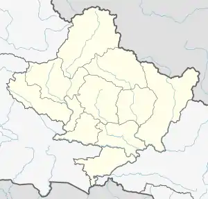 Waling Municipality Location in Gandaki Pradesh  Waling Municipality Waling Municipality (Nepal) | |
| Coordinates: 27°59′20″N 83°46′3″E | |
| Country | |
| Province | Gandaki Province |
| District | Syangja District |
| Government | |
| • Type | Mayor–council |
| • Mayor | Mr. Dilip Pratap Khand (NC) |
| • Deputy Mayor | Mrs. Kalpana Tiwari (NC) |
| Population (2011) | |
| • Total | 51,243 |
| Time zone | UTC+5:45 (NST) |
| Area code(s) | 063 |
| Website | walingmun.gov.np |
Waling bazaar is at the height of 800 meters from sea level while the municipality's height extends from 731 to 1596 meters and extends from 28 degrees latitude on the East to 83.45 degrees longitude. The municipality have two electoral constituencies, 3 DDC ilaka and 14 municipal wards.
The total area of Waling municipality is 34.76 km2. According to the 2011 national census, the municipality population is 51,243 with 1.7 percent population growth rate. The literacy rate is 81.71 percent, however, the municipality have already been declared fully literate. Nepal Government has declared the clean city of Nepal for fiscal year 2073
Early history
There are a number of stories about origin of the word Waling. One of them mentions it to be derived from the word wali - the monsoon folk songs sung by women in fields while planting paddy. Waling is famous for its unending paddy fields on the plains along banks of Aandhikhola River and the undulating terraces in mountain slopes that are crisscrossed by numerous creeks. Many people used to come to watch these festive women groups singing wali and planting paddy beautifully in unison in the monsoon drizzle.
The town is on the banks of the river Aandhikhola, which flows west along the valleys and gorges in the western lesser Himalayan mountains to meet the famous Kali Gandaki river. Hindu texts date the origin of Aandhikhola to the ancient time of Dvapara Yuga, described in the Puranas as the reign of King Dasharatha, the father of Lord Rama of Ramayana. During that time, a pious and aged blind couple had a devoted son named Shrawan Kumar. The old couple wished a pilgrimage before their death and Shrawan Kumar was on journey carrying them on his shoulder to fulfill their desire. On the way in a forest near Himalaya, his parents became very thirsty. He left them in a comfortable tree shade and rushed to a nearby river promising to return soon with water. As he hurriedly plunged his pitcher in the water, it produced a noise like that of a wild animal. King Dasaratha was hunting nearby and happened to hear the sound. The king could shoot his target without seeing the target only with guidance of sound. He assumed the sound to be of a wild beast and shot his arrows in the direction. As he arrived, he saw a young man lying dead with his arrow piercing his chest. He then saw the pitcher and immediately realized his mistake. The guilt-ridden king quietly carried water to the old couple but they demanded to know about their son before drinking it. When he told them about his mistake resulting in their son's death, they began to cry and died in the spot leaving behind a pool of tears which transformed into a small lake. A stream began to flow from this lake. The term 'Aandhi' means 'blind' and 'khola' means 'river' in Nepali language. Thus this new river got its name as Aandhikhola referring to tears of Shrawan Kumar's blind parents.
The Waling Municipality came into existence on 26 December 1996, by incorporating the then Walling, Dhanubase and Pekhubaghkhor village development committees.
Geography and climate
Average rain: 2265 mm
Minimum Temp: 9.5 degree Celsius
Maximum Temp: 32 degree Celsius
Climate: Tropical-Subtropical
It is situated between 713 and 1596 meters above sea level in the fold of the mountains that are considered part of inner lesser himalaya in Syangja district of western Nepal. The geology of inner Lesser Himalayan rocks constituting the Ksuma-Syangja area in western Nepal are separated into the Lower Nawakot Group, Upper Nawakot Group, Sirkot Group, and Tansen Group, respectively from bottom to top.[1]
Natural and artificially promoted erosion and slope instability in those hill and mountain area are drastically threatening the ecological balance. A geological study of rock structure and slope stability study of Walling area done in 1981 described a potential risk mapping method that was quick, giving a good picture of the condition of the terrain and based only on the relationship between the rock structure and topography.[2]
Syangja district has been described as one of the most disaster-prone areas in western Nepal. The geological and climatic condition have resulted in extremes of landslides, debris flow, flooding and wildfires. Most of the disasters have been natural and in the recent years, there is some evidence of increase of flooding, landsliding, deforestation and land degradation. The district ranked second highest, along with Makawanpur, with the total number of landslide events occurred during the period 1971–2000 being 46. It also ranked highest in terms of landslide density and loss of property compared to other districts. Landslides at Dhanubase (Dhanubaseko pahiro) is a major vulnerable hotspot in Waling area. Waling falls under the very high hazard probability area according to the Syangja district disaster management plan.[3]
Waling Municipality at a Glance (Year 1999/2000).[4]
- Area: 124895.40 square hectares.
- Arable land: 2696.70 sq hectares
- Residential area: 449.90 hectares
- Forest/Prairie Area : 4484.80 hectares
Cityscape
Waling stretches along the Aadhilhola river. Waling Municipality, in the initiation of Waling Jaycees, is launching a campaign from January 2012 to develop the city into a rose city with each residents planting at least two rose plants at their home.[5]
Notable buildings
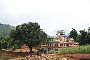
Patanjali Yogpeeth of Waling is a unique building built by Acharya Balkrishna and Yoga Guru Baba Ramdev of Patanjali Group of Institutions.
Demographics
According to 2011 Nepal census, Waling municipality had 5,952 households with a total population of 24,006 which comprised 10,809 males and 13,197 females.[6] as of 2011.[7] The population has increased since the time of the 1991 Nepal census, when it had a population of 8,767 people living in 1,674 ;individual households.[8]
Crime
The crime rate is relatively low compared to the other cities in the country.
Economy
Waling's economy is mainly based on the trade, foreign remittance and agricultural produce. Siddhartha Highway has been the economic life line connecting it to the major towns of Pokhara in the east and Siddharthanagar in the west. Before the construction of the Siddhartha Highway, Waling was a major trading outpost in the hilly trade trail connecting the towns in Terai and India with the Baglung Parbat, Kaski and the surrounding northern region.
Waling Municipality at a Glance (Year 1999/2000).
- Own Source Revenue: NRP 2923798
- Total Income: NPR 7307803
- Total Expenditure: NPR 6698217
- Number of Financial Institutions: 45
- Number of Industry:62
- Number of Shop: 1260
- Number of Hotel/Restaurant: 73
- Black Topped Road: 8 Kilometers
- Gravelled Road: 10 Kilometers
- Earthen Road: 31 Kilometers
- Number of Street Lights: 112
- Number of Telephone Line: 600
- Number of Post Office: 1
- Number of Public Toilet: 1
- Number of Public Drinking Water Tap: 1225
- Number of Private Drinking Water Tap: 75
- Number of Municipality Employee: 49
It is the local business center for the region with a number of food, construction materials, apparel and pharmaceutical retail and wholesale businesses. It elects its own chapter in the Federation of Nepalese Chamber of Commerce and Industry for the promotion of business and industry in the area. It receives a considerable amount of remittance sent by youths working mainly in India, Gulf countries and Malaysia. There is also a large number Indian and British army veterans living in the area whose remittance in the form of pensions and benefits has been a vital part of the economy since decades. Waling has a number of lodges and restaurants.
Financial institutions
- Siddhartha Bank Limited
- Nepal Bank Limited
- Garima Bikas Bank Limited
- Muktinath Bikas Bank Limited
- Laxmi Bank
- Nepal Investment Bank Ltd.(NIBL)
- Machhapuchchhre Bank
- NIC Asia Bank
- Prabhu Bank
- Nepal SBI Bank
- Mega Bank
- NMB Bank
- Agriculture Development Bank
- Gandaki Development Bank, Bhumre
- Kailash Bikash Bank
- Gandaki Development Bank, Waling
- NCC Bank Ltd.
- Janata Bank Ltd.
- Kumari Bank Ltd.
- Nabil Bank Limited
Agriculture
Agriculture continues to have a dominant share in the local economy. Most of the farmers have been sustenance farmers but lately many are also engaged in producing cash-crops which is sold in the nearby larger cities, mainly Pokhara and Butwal.
Paddy, wheat, maize, millet and legumes are the principal crops of the region. The production of rice and wheat crops in the same year is the predominant cropping pattern in the area. Weeds are a major problem in both crops grown under this system. A survey study during 1998/1999 wheat season identified major crop weeds in Waling, in decreasing dominant ratio, to be Soliva anthemifolia , Vicia sativa (local name: Kutil kosa/ akara ), Chenopodium album (local name: Narabethe/Bethe sag), Stellaria media, Cynodon dactylon, Polypogom fugax, Melilotus parviflora, Lactuca sp., Alopecurus sp, Phalaris minor, Polygonum hydropiper, Polygonum sp, Oxalis corniculata, Mazus sp., Gnaphalium sp., Lathyrus aphaca, Equisetum sp., Fumaria parviflora.[9]
The more fertile irrigated fields for those crops are at valley bottoms and foothills whereas the unirrigated terraces are at higher altitude. Waling is also famous as a major ginger-producing area in the Nepal since years. The other produces are oranges and green vegetables. In the recent years many farmers have also started coffee production, and the region is quickly becoming renowned for its high-quality organic coffee that gets exported to US, Japan and other parts of the world. Waling is the gateway to many villages that are focusing to add the village tourism in their economy.
Coffee is being cultivated between 700 m to 1300 m above sea level in fertile, loam to infertile gravel mixed soil in Waling area and other parts of Syangja district. The largest orchard in the district has 4000 plants and in others the number of plants ranges from 100 to 400. The common varieties of coffee grown in the area are Bourbon, Pacamara, Caturra and Yellow Caturra. Most of the coffee plantations in Syangja district have shades provided by already existing indigenous fruits and fodder plants as Sal, Katush, Chilaune, Nivaro, Badhar, Bedulo, Tote, Khaniya, Mayal, Kimbu, Suntala, Nibua, Amba, Kera, Mewa, Rukh katahar, Naspati, Aaru, Anar. Imported plants as Ipil-ipil, Rai grass, Dadaab have also been used as shade plants. The coffee is organically grown and plants such as garlic, chinaberry, neem, siam weed, stinging nettle, smart weed, mugwort, prickly ash, malabar nut tree, marigold and tobacco plant are usually used to prepare plant based organic pesticides for managing insects and diseases as a local solution. The relatively serious and common diseases identified in the plantation were Anthracnose (Colletotrichum gloeosporioides Penz.), Brown eye spot (Cercospora coffeicola), Damping off (Rhizoctonia solani), and Wilt disease (Fusarium spp.). Other minor diseases like sooty mould and algal spots have also been reported. Common insect pests in the orchard were white stem borer, red stem borer, green scale, mealy bugs, aphids, Snail, grasshopper, hopper, hairy caterpillar, case worm and tortoise beetles. A number of organizations like DCPA, CoPP HELVETAS, DADO and other local non-governmental organizations are providing support to the coffee farmers in the area.[10]
Waling is among the major areas in the Syangja district that produce sweet oranges. In 2010/2011, Syangja became the top district among 68 districts by producing 11,571 tonnes of oranges.[11]
Other traditional professions
Many households in Raipal of Waling municipality work as blacksmith. It is an ancestral tradition for many Dalits, mainly Biswakarma. Commonly manufactured items by forging wrought iron and steel are khukuris, sickles, spades, daggers and axes.[12]
Natural resources
The Department of Mine and Geology of Nepal has identified Waling among potential mining site for raw material for cement.[13]
Culture
The city has been organizing a festival called 'Waling Mahotsav' annually since the last three years. A huge number of people in the region flock the festival to watch and listen the artists singing the local folk songs 'lok-dohori' and other artists performing other cultural events. It also has numerous other entertainment stalls. It has also been a venue for promotion of local produce, industry and business.
Nepali is the language of communication of vast majority of the population in the city and region. The other major ethnic languages spoken by a number of people are Magar, Gurung and Newari. The Magars of Syangja and Palpa district speak in distinct western dialect of the magar language whereas those of the Tanahun, Gorkha and Nawalparasi speak in the eastern dialect.[14]
Community radio
Waling has two community radio stations.
Radio Andhikhola 105.4 MHz is a cooperative community radio station which was formally inaugurated on 22 November 2007. This is the first radio station of the Syangja district and can be heard in neighbouring 15 districts.[15]
Community Radio Waling 89.2 MHz (CRW) is a non-profit entity established by the NGO - AGECO Nepal, with a mission to promote organic agriculture for protection of environment and ecological conservation.[16]
Government
Waling is in the parliamentary constituency area number 2 of the Syangja district. In the constituent assembly election of 2008, Gopalman Shrestha of Nepali Congress got elected with 17247 votes. His nearest competitors in the election were Chakra Bahadur Parajuli of Communist Party of Nepal (UML) with 12173 votes and Deepa Bhusal of Communist Party of Nepal (Maoists) with 11824 votes.[17]
It also functions as the administrative center for the western Syangja district. Many government and other organizations have offices in Waling, including:
- Waling Municipality Office Waling Nagarpalika
- Area Administrative Office
- Office of the Department of Roads
- Sericulture Development Office
- Area Forest Office
- Nepal Telecom
- Butwal Power Company
- Area Police Office
- Armed Force Police Office
- Primary Health Center.
- Khahare Dhanubase Ayurveda Aushadhalaya
Health
A multi specialty Waling Hospital has been established in waling to provide semi major surgery's, health facilities.A cross-sectional survey conducted with sample population from two developing towns of western region, Waling bazar and Kusma bazar, found a relatively high point prevalence of 35.4% of conspicuous psychiatric morbidity (mental illness readily detected by primary care provider). This relatively high prevalence was thought to be due to less stable social structure in towns in transition.[18]
Waling continues to remain affected by the growing epidemic of HIV like the rest of the country. A NGO estimates the number of children affected by AIDS in Syangja to be about 800 and only 12% of them have been able to benefit from the offered services. Unlike other parts of the country where the majority of infected are dalits, the majority of the infected in Syangja are from brahmin, chhetri, magar community. Sankalpa Sahayog Samuha is the only organization in Syangja district working on protection, care and support on HIV/AIDS in Waling.[19]
The zoonotic pork tapeworm Taenia solium, which causes porcine cysticercosis and human taeniasis/cysticercosis, is also an increasing public health problem in Waling area like many other parts of the country where pork is commonly consumed. An epidemiological study of porcine cysticercosis in Tindobate, Tulsi Bhanjyang, Jagatradevi and Waling of Syangja district examined 419 pigs for lingual visualization and palpation for cysts and found that 32.4% were positive. The blood samples from 201 of those pigs in this study were also sent to Centers for Disease Control (CDC, Georgia, USA) for enzyme-linked immunoelectrotransfer blot (EITB) analysis and it showed a high prevalence rate of 24% while 6% of them had old infections or exposure.[20]
Waling Municipality at a Glance ( Year 2018).
- Number of Hospitals :2
- Number of Health Centers: 1
Education
The town has grown into an academic powerhouse of the region. Waling Campus was inaugurated in 18 December 1980 and is the first college in the Syangja district. The college has been extensively supported by the local community and it currently offers both undergraduate and postgraduate degree in a number of subjects. It is a private affiliated college of the national Tribhuvan University.
Purnamrit Bhawani High school is a high school in the region. Pioneers English Boarding School, Bhu Pu Sainik English School, BAL Vidhhya Vikash English School, Adarsha English Boarding School are the private high schools. There are a couple of primary schools and a paramedic training school.
Waling Municipality at a Glance ( Year 2015/16).[4]
- Number of Primary Schools: 17
- Number of Lower Secondary Schools: 3
- Number of Secondary Schools: 12
- Number of Technical Schools Under CTEVT: 3
- Number of Higher Secondary Schools: 12
- Number of College: 4
Transportation
Waling is gateway to many small villages in the Syangja district and neighboring Palpa, Kaski and Parbat district.
Air
- Pokhara Airport: about 63 Kilometers northeast from Waling. It is well connected by public buses, minibuses and taxis with a very frequent schedule.It is 3 km east from the existing domestic airport, at Chinnedanda. The construction of the airport started in April, 2017 and is expected to be completed after five years in 2022 with a cost of around US$305 million. The Ministry of Culture, Tourism and Civil Aviation awarded the contract to construct and develop the airport to China CAMC Engineering.[1] The airport is expected to handle one million passengers per year. Pokhara International Airport will have one runway measuring 2,500 by 45 metres. The airport will have concrete runway and jet bridges. The parking bays will be able to handle up to five narrow-body aircraft.
- Bhairahawa airport: about 160 Kilometers southwest from Waling. Buses and Minibuses leave daily and regularly from Bhairahawa to Pokhara via Waling along the Siddhartha Highway. The Airport will be upgraded into an international airport by 2020 and will be open on first quarter of 2020 on auspicious occation of Lord Gautam Buddha Birthday. It is planned to have a 3,000-m runway and have six international parking bays. The project will be financed by a loan and grant aid of $42.96 million and $12.75 million, respectively, from the Asian Development Bank.
Land
There is a frequent and daily schedule of buses and minibus run by the Siddhartha Highway Public Transport Syndicate, that leaves from Sunauli, Siddharthanagar and Butwal to Waling with their final destination of Pokhara along the Siddhartha Highway. The express service has fewer stops and relatively expensive while the local service has more stops along the way and relatively cheaper. There is a regular daily bus service connecting Waling with Nepalganj. From Pokhara, there is a very frequent schedule of minibuses and buses affiliated with the Siddhartha Highway Transportation Syndicate leaves to Waling from Pokhara Prithvi Chowk and Buspark. There are also a number of taxis which leave from the Pokhara Prithvi Chowk. They are relatively expensive but faster compared to buses and minibus. Average travel time in taxis is about 90 minutes from Pokhara to Waling. From Kathmandu, there is a frequent schedule of public buses and minibus leaving at early morning, morning, early afternoon and evening from the Kathmandu Buspark and Kalanki Chowk. Most of those are affiliated with the Prithvi Highway Transportation Syndicate. Kathmandu is about 260 kilometers from Waling and the average travel time is about 8–10 hours. The route is considered one of the most beautiful, crossing many small villages in the mountains of the middle hills of Nepal.
Media
To promote local culture Waling has one FM radio station Radio Aandhikhola - 105.4 MHz Which is a Community radio Station.
References
- Megh Raj Dhital, Prem Bahadur Thapa, Hisao Ando, Geology of the Inner Lesser Himalaya between Kusma and Syangja in Western Nepal, Bulletin of the Department of Geology, Vol 9 (2002)
- Alfred Wagner, Rock structure and slope stability study of Walling area, Central West Nepal, Jour. Nep. Geol. Soc., Vol. 1, No. 2, 1981, 37-43
- Shesh Kanta Kafle, Jyoti Sapkota, Shanta Upadhyaya, Total Disaster Risk Management (TDRM) Pilot Exercise:Disaster management action plan of Syangja District, Prepared by District Development Committee Syangja and Supported by United Nations Development Programme Nepal, March 2005.
- Source: Website of Government of Nepal, Ministry of Local Development(http://www.mld.gov.np/municipalities/waling.htm)
- The Himalayan Times (15 January 2012), Jaycees Plans to make Waling,'rose city'
- "National Population Census 2011" (PDF). Central Bureau of Statistics.
- "National Planning Commission Secretariat". Central Bureau of Statistics.
- "Syangja VDC Level Report" (PDF). Central Bureau of Statistics. Archived from the original (PDF) on 26 October 2014.
- Jagat D. Ranjit, Robin R. Bellinder, Peter Hobbs, Nabin K. Rajbhandari and Palit Kataki, Mapping Phalaris minor under the Rice-Wheat Cropping System in Different Agro-Ecological Regions of Nepal. Nepal Agriculture Research Journal, 2006, Volume 7, pages 54-62.
- Dhakal Dol P, Khadge BR, Giri YP, Aryal Sunil, Study on diseases and insect-pests of coffee in Nepal, Sept 2004. Source: http://www.cerambycoidea.com/abstracts/Nepal.htm
- The Kathmandu Post (Wednesday, 4 January 2012), Orange output reaches Rs 11.50 b
- The Kathmandu Post (Tuesday, 1 November 2011), In Love with Ancestral Profession
- The Kathmandu Post (Sunday, 4 August 2010), 3 Companies Vying for Mining Permit
- Karen Grunow-Hårsta, Adjectives and adjectivals in Magar, Himalayan Linguistics, Vol. 10(1).© Himalayan Linguistics 2011 ISSN 1544-7502
- http://www.radioandhikhola.org/
- http://www.radiowaling.org/
- http://www.election.gov.np/reports/CAResults/reportBody.php?selectedMenu=Constituency%20Wise%20Top%203%20Candidate(English)&rand=1326600750
- Upadhyaya K D, Pol K, A mental health prevalence survey in two developing towns of western region, Journal of Nepal Medical Association 2003; 4 2: 328-330
- Irada Parajuli Gautam (Consultant), Review of Children Affected By AIDS UNICEF Supported Interventions In Syangja and Accham Districts,15 July 2009.
- Durga Datt Joshi, Mahendra Maharjan, Maria Vang Johnsen, Arve Lee Willingham, Yogendra Gaihre and Minu Sharma, Taeniasis/Cysticercosis Situation in Nepal, The Southeast Asian Journal of Tropical Medicine and public Health, Volume 35, Supplement 1, 2004.