Gandaki Province
Gandaki Province (Nepali: गण्डकी प्रदेश [ɡʌɳɖʌki]) is one of the seven federal provinces established by the current constitution of Nepal which was promulgated on 20 September 2015.[1] Pokhara is the province's capital city. It borders the Tibet Autonomous Region of China to the north, Bagmati Province to the east, Karnali Province to the west, and Lumbini Province and Bihar of India to the south. The total area of the province is 21,504 km² - about 14.57% of the country's total area. According to the latest census, the population of the province was 2,403,757.[2] The newly elected Provincial Assembly adopted Gandaki Province as the permanent name by replacing its initial name Province no. 4 in July 2018.
Gandaki Province
गण्डकी प्रदेश Gandaki Pradesh | |
|---|---|
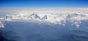 .JPG.webp) 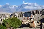 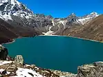 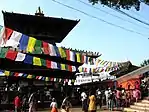 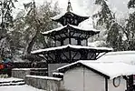 .jpg.webp) 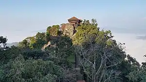 From Top left to right Annapurna, Machapuchare, Upper Mustang, Tilicho Lake, Manakamana Temple, Muktinath Temple, Phewa Lake and Gorkha Durbar | |
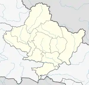
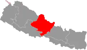 Location of Gandaki Province
| |
| Coordinates: 28°12′34″N 83°59′29″E | |
| Country | |
| Formation | 20 September 2015 |
| Capital city | Pokhara |
| Largest city | Pokhara |
| Districts | 11 |
| Government | |
| • Body | Government of Gandaki Pradesh |
| • Governor | Amik Sherchan |
| • Chief Minister | Prithvi Subba Gurung (NCP) |
| • High Court | Pokhara High Court |
| • Provincial Assembly | Unicameral (60 seats) |
| • Parliamentary constituencies | 18 |
| Area | |
| • Total | 21,504 km2 (8,303 sq mi) |
| Area rank | 4th |
| Population (2011) | |
| • Total | 2,403,757 |
| • Rank | 6th |
| • Density | 110/km2 (290/sq mi) |
| • Density rank | 6th |
| Demonym(s) | Paschimeli Nepali |
| Time zone | UTC+5:45 (NST) |
| Geocode | NP-FO |
| Official language | Nepali |
| Other language(s) | 1. Gurung 2. Magar |
| HDI | 0.567 (medium) |
| Literacy | 74.81% |
| Sex ratio | 83.84 ♂ /100 ♀ (2011) |
| Website | ocmcm |
Etymology
Gandaki Pradesh named after the river Gandaki. Gandaki is a major river in the province. This river has Important links with historical Hindu civilization. The Gandaki river is mentioned in the ancient Sanskrit epic Mahabharata. It is said that Valmiki Rishi (sage) wrote the great epic, "Ramayana" here. It is also believed to be the birthplace of Luv & Kush. Its evolution is described in Shiva Purana, Kumarakhand, in the chapter of the killing of Shankhachuda.
History
Gandaki Pradesh was known as "Gandak Kshetra" which was established in 1956. Gandak Kshetra was composed by grouping the then 4 districts. Those 4 districts are now divided into many districts. Gandak Kshetra had total area of 5,400 square miles (14,000 km2) and total population was 12 Lakhs.[3] The four districts were:
- Lumbini District (Rupandehi, Parasi, Palpa)
- Syangja District (Syangja, Nuwakot)
- Pokhara District (Tanahun, Kaski)
- Gorkha District (Gorkha, Lamjung, Manang)
In 1962, administrative system restructured again and the "Kshetras" system cancelled. The country restructured into 75 development districts and those districts were grouped into zones.[4] In 1972 area of the Gandaki Pradesh named Western Development Region. It had 3 zones and 16 districts.
Geography
The province has an area of 21,773 km2 which is about 14.66% of the total area of Nepal. The state is extends between 27°-20' N ~ 29°-20' N latitude and 82° 52' E ~ 85°-12' E longitude. In terms of terrain, the province is spread over the Himalayan, Hilly and Terai region of Nepal; 5,919 km2 (26.8%) of the area falls under the Himalayan region, 14,604 km2 (67.2%) of the area falls under the Hilly region and 1,310 km2 (6%) of the area falls under the Terai region.[5]
| Location | August
(°F) |
August
(°C) |
January
(°F) |
January
(°C) |
Annual
Precipitation |
|---|---|---|---|---|---|
| Baglung | 72.1 | 22.3 | 47.5 | 8.6 | 1766.1/69.5 |
| Besishahar | 72.3 | 22.4 | 47.5 | 8.6 | 1639.6/64.6 |
| Chapakot | 60.2 | 20.4 | 46.5 | 9.6 | 1766.1/69.5 |
| Modi | 60.8 | 16 | 33.4 | 0.8 | 1094.7/43.1 |
| Pokhara | 74.8 | 23.8 | 50.4 | 10.2 | 2010.3/79.1 |
| Waling | 77.5 | 25.3 | 54.1 | 12.3 | 1962.7/84.5 |
Government and administration
The Governor acts as the head of the province while the Chief Minister is the head of the provincial government. The Chief Judge of the Pokhara High Court is the head of the judiciary.[7] The present Governor, Chief Minister and Chief Judge are Baburam Kunwar (governor), Prithvi Subba Gurung (chief minister) and Purushottam Bhandari.[8][9] The province has 60 provincial assembly constituencies and 18 federal House of Representative constituencies.[10]
Gandaki Pradesh has a unicameral legislature, like that of the other provinces in Nepal. The tenure of provincial assembly is of five years. The Provincial Assembly of Gandaki Pradesh is temporarily housed at the Urban Development Training Centre in Pokhara.[11]
Administrative subdivisions
Gandaki province is divided into 11 districts, which are listed below. A district is administrated by the head of the District Coordination Committee and the District Administration Officer. The districts are further dived to municipalities or rural municipalities. The municipalities include one metropolitan city and 26 municipalities. There are 58 rural municipalities in the province.[12]
Demographics
The province has a population of 2,403,016 which is just about 9.06% of the total population of Nepal. The population density is about 110 persons per square kilometre. The province has a population growth rate of -0.33%. The sex ratio is 89 males for 100 females, with a total of 948,028 males and 1,144,124 females recorded in 2011. The urban population of the region is 1,452,186 (60.5%) and the rural population is 943,652 (39.5%). About 50.1% of the population in the province are independent population.[5]
Language
According to the 2011 Nepal census there are total 88 languages spoken in Gandaki Pradesh. Nepali, Magar, Tharu, Gurung, Kumal, Darai, Ghale, Thakali etc are main languages which is spoken by communities in Gankldaki Pradesh. Mostly spoken language is Nepali which is spoken by 68.885 percent people of Gandaki Pradesh. Magar is secondly most spoken language with percentage of 9.025 and Gurung is third mostly spoken language with percentage of 7.855.[14]
References
- "Nepal Provinces". statoids.com. Retrieved 2016-03-21.
- "Gandaki Province in Nepal population". www.citypopulation.de. Retrieved 2018-06-04.
- नेपालको जिल्ला प्रशासन पुनर्गठनको रिपोर्ट, २०१३ (PDF). Nepal: Nepal Govt. pp. 38, 39, 40.
- "Memorial Step of King Mahendra in 1st Poush 2017 BS". reviewnepal.com. 13 December 2017. Retrieved 6 February 2018.
- "Province Profile" (PDF). Government of Province No. 4. Archived from the original (PDF) on 2018-04-28. Retrieved 2018-04-28.
- "Nepal Travel Weather Averages (Weatherbase)". Weatherbase. Retrieved 2018-04-28.
- "High Courts get their chief judges". Retrieved 2018-04-27.
- "Prithvi Subba Gurung appointed as Province 4 CM - The Himalayan Times". The Himalayan Times. 2018-02-12. Retrieved 2018-04-27.
- "President of Nepal administers oath to Chiefs of seven provinces | DD News". ddnews.gov.in. Retrieved 2018-04-27.
- "CDC creates 495 constituencies". The Himalayan Times. 2017-08-31. Retrieved 2018-04-27.
- "First Provincial Assembly meeting of province 4 begins". Retrieved 2018-04-27.
- "स्थानिय तह". 103.69.124.141. Archived from the original on 2018-08-31. Retrieved 2018-04-27.
- http://parliament.gov.np/np/ncd.html
- "गण्डकी प्रदेशको भाषिक स्थिति" [Linguistic status of Gandaki Pradesh]. www.annapurbapost.com (in Nepali). Annapurna Post. 7 December 2018. Retrieved 7 December 2018.
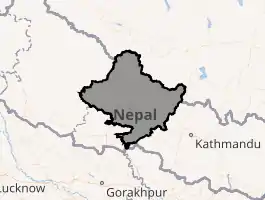
Places adjacent to Gandaki Province | |
|---|---|
Nepal articles | ||||||||||||||||||
|---|---|---|---|---|---|---|---|---|---|---|---|---|---|---|---|---|---|---|
| History |
|  | ||||||||||||||||
| Geography |
| |||||||||||||||||
| Politics |
| |||||||||||||||||
| Economy | ||||||||||||||||||
| Culture |
| |||||||||||||||||
| ||||||||||||||||||