Wangara, Western Australia
Wangara is a light industrial suburb of Perth, Western Australia, located within the City of Wanneroo.
| Wangara Perth, Western Australia | |||||||||||||||
|---|---|---|---|---|---|---|---|---|---|---|---|---|---|---|---|
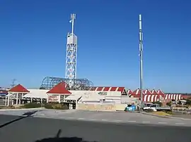 Wanneroo Market in Wangara | |||||||||||||||
 Wangara | |||||||||||||||
| Coordinates | 31.791°S 115.829°E | ||||||||||||||
| Population | 39 (2016 census)[1] | ||||||||||||||
| • Density | 6.96/km2 (18.0/sq mi) | ||||||||||||||
| Postcode(s) | 6065 | ||||||||||||||
| Area | 5.6 km2 (2.2 sq mi) | ||||||||||||||
| LGA(s) | City of Wanneroo | ||||||||||||||
| State electorate(s) | Landsdale | ||||||||||||||
| Federal Division(s) | Cowan | ||||||||||||||
| |||||||||||||||
Wangara is one of Perth's busiest industrial areas. It is situated roughly 20 km north of the central business district, and is the industrial hub of the north side of Perth. It is also roughly 10 km from Joondalup, Perth's largest satellite city north of the Swan River. It has a wide range of warehouses and industrial services, and some commercial services such as new and used car dealerships, mechanics, industrial work wear, excavation services, landscaping products, and gas conversion.
Transport
The Transperth operated bus route 389 runs from Wanneroo to Perth, up and down Wanneroo Road.[2] The 355 and 468 also services to Whitfords railway station and down Prindiville Drive, Joondalup Station or Ellenbrook. On the southern end number 376 runs from Whitfords to Mirrabooka via Landsdale.
References
- Australian Bureau of Statistics (27 June 2017). "Wangara (State Suburb)". 2016 Census QuickStats. Retrieved 23 August 2019.

- "Bus Route 389 Timetable". Transperth. Retrieved 23 August 2019.
Suburbs and localities of the City of Wanneroo, Perth, Western Australia | ||
|---|---|---|
| North West | 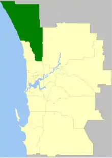 | |
| North East | ||
| South | ||
¹ Suburb shared with the City of Joondalup | ||