Washington State Route 8
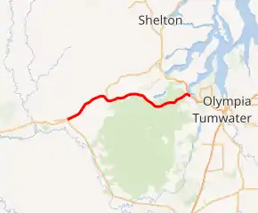
State Route 8 (SR 8) is a state highway in Grays Harbor and Thurston counties, of the U.S. state of Washington. It extends 20.67 miles (33.27 km) from U.S. Route 12 (US 12) in the city of Elma, east to an interchange with US 101 about 5.90 miles (9.50 km) northwest of the state capital, Olympia. SR 8 intersects SR 108 west of McCleary. The route connects Elma and Olympia as part of a corridor between Aberdeen and the Puget Sound region.
| ||||
|---|---|---|---|---|
SR 8 highlighted in red | ||||
| Route information | ||||
| Defined by RCW 47.17.035 | ||||
| Maintained by WSDOT | ||||
| Length | 20.67 mi[1] (33.27 km) | |||
| Existed | 1964[2]–present | |||
| Major junctions | ||||
| West end | ||||
| East end | ||||
| Location | ||||
| Counties | Grays Harbor, Thurston | |||
| Highway system | ||||
| ||||

The highway was part of the Elma – Grand Mound branch of Primary State Highway 9 (PSH 9 EG) from 1937 until 1964, which ran from Elma southeast to Interstate 5 (I-5), formerly US 99 in Grand Mound, which was later added as part of US 12 in 1967. The road also forms the northern boundary of Capitol State Forest in Thurston County.
Route description
SR 8 runs 20.67 miles (33.27 km) east from US 12 in Elma to an interchange with US 101 5.90 miles (9.50 km) northwest of Olympia.[1] The route links the city of Elma with Olympia, and intersects only one other highway, SR 108, in McCleary.[3][4][5] WSDOT has found that more than 17,000 motorists utilize the road daily at the interchange with US 101 based on average annual daily traffic (AADT) data.[6]
SR 8 starts at an interchange with US 12 near downtown Elma. From the interchange, the expressway goes northeast and starts to parallel the Chehalis River.[7] After crossing the river twice, the highway intersects SR 108, which goes northeast towards Kamilche, west of McCleary. After passing Downtown McCleary, SR 8 has a partial cloverleaf interchange with Mox Chehalis Road. From the interchange, the expressway goes east to form the northern boundary of the Capitol State Forest,[8] and passes Summit Lake.[9] From Summit Lake, the highway turns northeast and merges with US 101 southbound.[3][10]
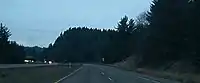
The entire length of SR 8 is expressway. When combined with US 12 to the west and US 101 to the east, it serves as the primary connection between the Puget Sound region and Washington's Pacific coast.
History
Before the Primary and Secondary system, SR 8 in 1923 was part of a branch of State Road 9, from Elma to Grand Mound.[11] Later, in 1937, the route from Elma to Grand Mound became part of Elma – Grand Mound branch of Primary State Highway 9 (PSH 9 EG).[12] PSH 9 EG became SR 8 in 1964 during the 1964 highway renumbering, in which the Washington State Department of Transportation (WSDOT) replaced the previous system of Primary and Secondary Highways with a new system called State Routes, which is still in use today.[13][14]
.png.webp)
Later in 1967, US 12 was extended from Lewiston, Idaho westward to Aberdeen.[15] It was approved on June 20, 1967, and it replaced the route of US 410, therefore making the highway obsolete.[15] Since US 12 used the all-weather White Pass and SR 8 from Elma to Grand Mound, and US 410 used Chinook Pass, which was closed during the winter, US 12 bypassed US 410 and what is now SR 8.[16] Signs were changed in late December 1967,[17] and the bypassed segments of US 410 became a new SR 8.[18][19]
On June 9, 2007, a tanker fire occurred on SR 8 when a tanker truck with 10,000 gallons of fuel collided with another vehicle and started a fire. The fire caused SR 8 to close for a couple of hours except for the westbound left lane, which crews used to get oil out of the soil underneath the highway.[20] During the Winter 2007 storm, a slope that held up SR 8 was eroded by floodwaters. The slope, located on SR 8 west of the US 101 interchange, and is scheduled to begin this season and last 2 months.[21] In 2010, WSDOT aims to rebuild the columns that support the SR 8/US 101 interchange and reduce the risk of failure in an earthquake, such as the 2001 Nisqually earthquake.[22]
Major intersections
| County | Location | mi[1] | km | Destinations | Notes |
|---|---|---|---|---|---|
| Grays Harbor | Elma | 0.00 | 0.00 | Continues as US 12 west | |
| Interchange; westbound exit and eastbound entrance | |||||
| McCleary | 6.03 | 9.70 | |||
| 7.39 | 11.89 | Mox Chehalis Road – McCleary | Partial cloverleaf interchange | ||
| Thurston | | 20.67 | 33.27 | Interchange; eastbound exit and westbound entrance | |
| 1.000 mi = 1.609 km; 1.000 km = 0.621 mi | |||||
References
- Washington State Department of Transportation. "State Highway Log, 2006" (PDF). Retrieved October 19, 2008.
- Washington State Legislature. "RCW 47.17.035: State Route 8". Retrieved October 19, 2008.
- Google (October 19, 2008). "State Route 8 Map" (Map). Google Maps. Google. Retrieved October 19, 2008.
- The Road Atlas (Map). Rand McNally. 2008. p. 108. § H4, H5, H6. ISBN 0-528-93961-0.
- Olympia, Lacey, Tumwater, Thurston County (Map) (2007 ed.). City Street Maps. G.M. Johnson. 2007. Retrieved October 19, 2008.
- Washington State Department of Transportation (2007). "Washington Annual Average Daily Traffic Data" (PDF). Retrieved October 19, 2008.
- Port Angeles, Port Townsend, Sequim, Aberdeen, Hoquiam (Map) (2008 ed.). City Street Maps. G.M. Johnson. 2008. Elma inset. Retrieved October 23, 2008.
- Google (October 19, 2008). "Capitol State Forest" (Map). Google Maps. Google. Retrieved October 19, 2008.
- SR 8 – Emergency Slide Repair – Unstable Slope Map (Map). Cartography by Tele Atlas. Washington State Department of Transportation. 2007. Retrieved October 19, 2008.
- Official State Highway Map (PDF) (Map) (2008–2009 ed.). 1:842,000. Official State Highway Maps. Cartography by U.S. Geological Survey. Olympia, Washington: Washington State Department of Transportation. 2008. § E2. Retrieved October 19, 2008.
- Washington State Legislature (1923). "185". Session Laws of the State of Washington. Session Laws of the State of Washington (1923 ed.). Olympia, Washington: Washington State Legislature. Retrieved October 19, 2008.
- Washington State Legislature (1937). "190". Session Laws of the State of Washington (PDF). Session Laws of the State of Washington (1937 ed.). Olympia, Washington: Washington State Legislature. Retrieved October 19, 2008.
- C. G. Prahl, Washington State Highway Commission (December 1, 1965). "Identification of State Highways, Part 1" (PDF).
- C. G. Prahl, Washington State Highway Commission (December 1, 1965). "Identification of State Highways, Part 2" (PDF).
- Weingroff, Richard F. (May 7, 2005). "U.S. 12 Michigan to Washington". Federal Highway Administration. Retrieved October 19, 2008.
- "All-Weather Plan Picked By Highway Commission". Walla Walla Union-Bulletin. April 23, 1967. p. 5.
- "Highway 410 is now U.S. No. 12". Walla Walla Union-Bulletin. December 28, 1967. p. 1.
- "U-B Action Line". Walla Walla Union-Bulletin. September 29, 1968. p. 1.
- Washington State Highway Commission (1970). "Annual Traffic Report" (PDF). Retrieved October 19, 2008.
- Stowe, Kelly. "Lane Closures Continue on SR 8 after Tanker Fire". Washington State Department of Transportation. Archived from the original on June 28, 2008. Retrieved October 19, 2008.
- Washington State Department of Transportation. "SR 8 – Emergency Slide Repair – Unstable Slope". Retrieved October 19, 2008.
- Washington State Department of Transportation. "SR 8 – US 101 Undercrossing – Seismic Retrofit". Retrieved October 19, 2008.