Waterview, New Zealand
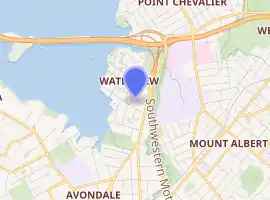
Waterview is a suburb of Auckland, New Zealand, located along the western side of Auckland's isthmus. Its boundaries are Oakley Creek in the east, Heron Park in the south, the Waitematā Harbour (and Motu Manawa (Pollen Island) Marine Reserve) in the west, and the Northwestern Motorway and the Oakley Creek inlet in the north.[1][2]
Waterview | |
|---|---|
Suburb | |
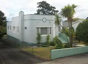 Waterview contains a variety of house styles, including a small number of Art Deco bungalows. | |
| |
| Country | New Zealand |
| Local authority | Auckland Council |
| Electoral ward | Albert-Eden-Puketāpapa Ward |
| Population (2018) | |
| • Total | 3,375 |
| (Waitematā Harbour) | Point Chevalier | Point Chevalier |
| (Waitematā Harbour) |
|
Mount Albert |
| Rosebank | Avondale | Mount Albert |
Waterview is primarily a residential area, with its residents commuting to work. There are few shops: a dairy, laundromat, bakery, and a community-owned cafe.[3] Community facilities are available at Point Chevalier or Avondale, 20–30 minutes walk away.[1][2]
Demographics
| Year | Pop. | ±% p.a. |
|---|---|---|
| 2006 | 3,345 | — |
| 2013 | 3,303 | −0.18% |
| 2018 | 3,375 | +0.43% |
| Source: [4] | ||
Waterview had a population of 3,375 at the 2018 New Zealand census, an increase of 72 people (2.2%) since the 2013 census, and an increase of 30 people (0.9%) since the 2006 census. There were 1,149 households. There were 1,623 males and 1,749 females, giving a sex ratio of 0.93 males per female. The median age was 32.9 years, with 603 people (17.9%) aged under 15 years, 882 (26.1%) aged 15 to 29, 1,587 (47.0%) aged 30 to 64, and 300 (8.9%) aged 65 or older.
Ethnicities were 54.6% European/Pākehā, 10.7% Māori, 20.5% Pacific peoples, 21.6% Asian, and 6.4% other ethnicities (totals add to more than 100% since people could identify with multiple ethnicities).
The proportion of people born overseas was 37.2%, compared with 27.1% nationally.
Although some people objected to giving their religion, 48.2% had no religion, 35.1% were Christian, and 11.7% had other religions.
Of those at least 15 years old, 984 (35.5%) people had a bachelor or higher degree, and 339 (12.2%) people had no formal qualifications. The median income was $35,300. The employment status of those at least 15 was that 1,503 (54.2%) people were employed full-time, 402 (14.5%) were part-time, and 135 (4.9%) were unemployed.[4]
History
The Waterview area, especially along the coast and inlet areas, has a relatively high incidence of archeologically significant areas, from old settlement remnants (both Maori and early European settler), to a comparatively well-retained site of an old mill/tannery and quarry (Star Mill/Garret Bros Tannery) which is scheduled as a Category I Historic Place, and which once used the stream waters to drive a waterwheel.[1][2]
The population of Waterview has been stable since the 2006 census.[4]
Transport
A major issue that faced Waterview was the construction of SH20 from Hillsborough through to the Northwestern Motorway. The route through Waterview was highly contentious until (and to a degree after) a fast-tracked Board of Inquiry process consented a route in mid-2011, which placed a new motorway tunnel portal and motorway interchange at the north end of the suburb, causing the removal of numerous homes in the area.[5][6]
Public transport facilities from Waterview allow access to a range of destinations in Auckland City, and a shared walking and cycling path is proposed to link Waterview with Mt Albert and several other suburbs along the State Highway 16 cycle route.[7]
Education
Waterview Primary School is a coeducational contributing primary (years 1-6) school with a roll of 310 as of March 2020.[8][9] The school opened in 1950. It had to be demolished and a new school built as part of the Waterview Connection.[10][11]
There is no secondary school in the suburb; nearby state secondary schools include Avondale College, Western Springs College and Mount Albert Grammar School.
References
- Waterview Connection - Assessment of Environmental Effects: Part C. New Zealand Transport Agency. August 2010. pp. 8.14–8.17.
- "My Neighbourhood: Margi Watson's Waterview". Localist. November 2011. Retrieved 22 December 2011.
- The Waterview Coffee Project
- "Statistical area 1 dataset for 2018 Census". Statistics New Zealand. March 2020. Waterview (131100). 2018 Census place summary: Waterview
- Dearnaley, Mathew (4 September 2010). "Waterview project on fast track". The New Zealand Herald. Retrieved 4 October 2010.
- "Demolition kicks off motorway project". New Zealand Herald. 4 November 2012.
- "Open Days for Waterview Shared Path". Retrieved 30 April 2015.
- "New Zealand Schools Directory". New Zealand Ministry of Education. Retrieved 26 April 2020.
- Education Counts: Waterview School
- "Waterview Primary to be demolished". New Zealand Herald. 31 October 2012.
- Lynn, Alistair (18 December 2015). "Waterview Primary School begins $17 million redevelopment". New Zealand Herald.
External links
- Photographs of Waterview held in Auckland Libraries' heritage collections.