Waterville, Dublin
Waterville (Irish: An Coireán) is a modern housing development that forms a remote suburb of Dublin city, within Fingal, Ireland. The developments were built between 2002 - 2008 and 2013 - 2016 (Brandon Square and Rossan Court) on the edge of the Abbotstown demense, close to Blanchardstown village. [1] The development lies within the townland if Deanestown[2] in the civil parish of Castleknock.
History
The area was developed by Granbrind Ltd on land acquired from the Eastern Health Board. The land was previously owned successively by the Barons of Castleknock, Baronets of Abbotstown and the barons HolmPatrick. These lands formed the principal seat in the civil parish which was part of the barony of Castleknock.[3]
Waterville is located on the southern edge of Abbotstown Demense which remained in the ownership of the Tyrell family until about 1400 when Thomas Sergent and his wife Joan Tyrell, sister to the last Tyrell Baron of Castleknock, were in residence. By the 17th century, they had passed to the Sir John Dungan who owned one thatched house, several cottages and an old church at Abbotstown. Later, the lands at Abbotstown were owned by the Clements family, ancestors to the Earls of Leitrim and famous for the fact that one of their number was Nathaniel Clements, Chief Ranger in the Phoenix Park, where his residence later became the official residence of the President of Ireland, Áras an Uachtaráin.[4]
The most famous family to live on the lands at Waterville was the Falkiner family, ennobled as "Baronets of Abbotstown" in 1812. The Falkiners married into the Hamilton family who had lands in the neighbouring townland of Sheephill.[5] In 1832, both estates were amalgamated by the Hamiltons and a new residence, Abbotstown House, was built as the family seat.
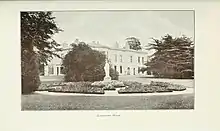
Ion Trant Hamilton was ennobled by Queen Victoria as Baron HolmPatrick. Abbotstown House remained the seat of the barons until 1947 when James Hans Hamilton, 3rd Baron HolmPatrick (1928–1991), lost part of his lands under a Compulsory Purchase Order to allow for the building of James Connolly Memorial Hospital. Later, Lord HolmPatrick sold the remaining lands at Abbotstown and Sheephill to the Marine Institute of Ireland. The Institute was located at Abbotstown House until 2005 when the house was acquired for Sports Campus Ireland.[6] In the late 1990s half of the lands under the ownership of the health board were sold for development in order to finance the redevelopment of the hospital buildings.[7]
Location and name
The development of 1500 homes at Deanestown and Sheephill was called Waterville due to its proximity to the River Tolka. Waterville lies on the northern banks of the Tolka covering about 50 acres of land.

It is bordered to the south by the Navan Road (N3), to the west by the Snugborough Road (R843), to the north by the playing fields of the National Sports Campus and to the east by Connolly Hospital in the townland of Abbotstown. Waterville is approx. 9 km from the centre of Dublin city, 2.5 km from Castleknock railway station, 2 km from the village of Blanchardstown and 4.5 km from the Phoenix Park.[8] Each area within Waterville is privately owned and managed, and each is named after an Irish coastal promontory or island, as follows:
- Brandon Square
- Tory Square
- Blasket Square
- Annagh Court
- Skelligs Court
- Aran Court
- Garnish Square
- Dursey Row
- Bantry Square
- Erris Square
- Achill Square
- Kylmore Terrace
- Rossan Court
- Waterville Terrrace
Many of the developments in Waterville were built around a central green, while the overall development was built in an integrated fashion merging with the established forestry and parklands.
Waterville also has a 25 acre park called Waterville Park where there is a lake full of swans and ducks. The lake also has an Island in it and another lake above it. The Park's also features a playground.
Waterville also boasts a Spar shop and a Creche, Little Stars.
Access and public transport
Situated adjacent to the N3 and the M50, Waterville is only nine kilometres from the city centre, and has excellent access to the entire national roads network. It is connected to the M3 by a link road.
Public transport is very accessible with the following bus routes available:- 38, 38a, 38b, 39, 39a, 70, 76a, 220, 238, 239 and the 70n Nitelink stop just a short stroll away. It is close to Clonsilla and Castleknock train stations, providing a train service via Ashtown, Cabra, Drumcondra to Connolly Station and Busaras (Central Bus Station).
References
- Rocque Map of Castleknock, 1762.
- Placenames Database of Ireland - Deanestown town
- See Map for Fingal County Development Plan 1999- Variation No. 31 (Lands at James Connolly Memorial Hospital)
- Lacey, J. 1999. A Candle in the Window: A History of the Barony of Castleknock. Dublin. Marino Books. p. 84
- Placenames Database of Ireland - Sheephill townland
- Lacey, J. 1999. A Candle in the Window: A History of the Barony of Castleknock. Dublin. Marino Books. p. 84.
- Fingal Development Plan. 1999.
- Comhairle Contae Fhine Gall, Minutes of Council Meeting CMB/62/06 WATERVILLE PARK 2 March 2006.
External links
- Waterville - Developer's Website
- Bright and Spacious - Independent article from 17 October 2008
- Big Splash - Independent article from 13 March 2009
- National Aquatic Centre
- Castleknock Railway Station
- First phase of mixed units in former hospital grounds from £133,000 Irish Times article from 22 March 2001