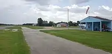
Weiser Air Park
Weiser Air Park (ICAO: KEYQ, FAA LID: EYQ) was a privately owned, public-use airport located on the Northwest Freeway (U.S. Highway 290) in Cypress, an unincorporated area of Harris County, Texas, United States.[2] The airport was 11 nautical miles (20 km) northwest of the central business district of Houston[1]
Weiser Air Park | |||||||||||||||
|---|---|---|---|---|---|---|---|---|---|---|---|---|---|---|---|
 | |||||||||||||||
| Summary | |||||||||||||||
| Airport type | Public | ||||||||||||||
| Owner | Cecil & Robert Weiser | ||||||||||||||
| Serves | Houston, Texas | ||||||||||||||
| Location | Harris County, Texas | ||||||||||||||
| Closed | November 3, 2019 | ||||||||||||||
| Elevation AMSL | 137 ft / 42 m | ||||||||||||||
| Coordinates | 29°56′07″N 095°38′23″W | ||||||||||||||
| Website | www.WeiserAirpark.com | ||||||||||||||
| Runways | |||||||||||||||
| |||||||||||||||
| Statistics (2006) | |||||||||||||||
| |||||||||||||||
Although most U.S. airports use the same three-letter location identifier for the FAA and IATA, Weiser Air Park was assigned EYQ by the FAA but had no designation from the IATA.[3]
Facilities and aircraft
Weiser Air Park covered an area of 102 acres (41 ha) at an elevation of 137 feet (42 m) above mean sea level. It had two runways: 9/27 has a 3,455 x 40 ft (1,053 x 12 m) asphalt pavement and 16/34 has a 2,000 x 33 ft (610 x 10 m) turf surface.[1]
For the 12-month period ending March 3, 2006, the airport had 38,020 aircraft operations, an average of 104 per day: 99.9% general aviation and 0.1% air taxi. At that time there were 75 aircraft based at this airport: 93% single-engine and 7% multi-engine.[1]
History
The Jackson Airport grass strip was purchased by Cecil Weiser in 1951, and renamed Weiser Airpark in 1963. The runway was paved in 1980. Cecil died in Nov. 2017, followed by the sale of the 102 acres.[4]
References
- FAA Airport Form 5010 for EYQ PDF, effective 2008-04-10
- Weiser Air Park
- Great Circle Mapper: KEYQ - Houston, Texas (Weiser Air Park)
- Begley, Dug. "Weiser Airpark flies into the sunset with one last party and some final high moments before the planes move away". Houston Chronicle. Hearst. Retrieved 14 June 2019.
External links
- Resources for this airport:
- FAA airport information for EYQ
- AirNav airport information for EYQ
- FlightAware airport information and live flight tracker
- SkyVector aeronautical chart for EYQ