Whitestone, Alaska
Whitestone is an unincorporated community and census-designated place in Southeast Fairbanks Census Area, Alaska, United States. Its population was 97 as of the 2010 census.[1] This is not to be confused with Whitestone Logging Camp CDP in the Alaskan panhandle.
Whitestone, Alaska | |
|---|---|
 Whitestone, Alaska | |
| Coordinates: 64°09′10″N 145°54′23″W | |
| Country | United States |
| State | Alaska |
| Census Area | Southeast Fairbanks |
| Area | |
| • Total | 7.065 sq mi (18.30 km2) |
| • Land | 7.065 sq mi (18.30 km2) |
| • Water | 0 sq mi (0 km2) |
| Elevation | 984 ft (300 m) |
| Population | |
| • Total | 97 |
| • Density | 14/sq mi (5.3/km2) |
| Time zone | UTC-9 (Alaska (AKST)) |
| • Summer (DST) | UTC-8 (AKDT) |
| Area code(s) | 907 |
| GNIS feature ID | 2582719[2] |
Geography
According to the U.S. Census Bureau, the community has an area of 7.065 square miles (18.30 km2), all of it land.[1]
Demographics
| Historical population | |||
|---|---|---|---|
| Census | Pop. | %± | |
| 2010 | 97 | — | |
| U.S. Decennial Census[3] | |||
Whitestone first appeared on the 2010 U.S. Census as a census-designated place (CDP).
References
- "2010 Census Gazetteer Files - Places: Alaska". U.S. Census Bureau. Retrieved January 17, 2017.
- "Whitestone Census Designated Place". Geographic Names Information System. United States Geological Survey.
- "U.S. Decennial Census". Census.gov. Retrieved June 6, 2013.
Municipalities and communities of Southeast Fairbanks Census Area, Alaska, United States | ||
|---|---|---|
| Cities | 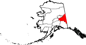 Southeast Fairbanks Census Area map | |
| CDPs | ||
| Unincorporated communities | ||
| ||
This article is issued from Wikipedia. The text is licensed under Creative Commons - Attribution - Sharealike. Additional terms may apply for the media files.