Wilder, Minnesota
Wilder is a city in Jackson County, Minnesota, United States. The population was 60 at the 2010 census.[6]
Wilder | |
|---|---|
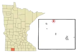 Location of Wilder, Minnesota | |
| Coordinates: 43°49′41″N 95°11′58″W | |
| Country | United States |
| State | Minnesota |
| County | Jackson |
| Government | |
| • Type | Mayor – Council |
| • Mayor | Kenny Hunter, Jr. |
| Area | |
| • Total | 0.79 sq mi (2.04 km2) |
| • Land | 0.79 sq mi (2.04 km2) |
| • Water | 0.00 sq mi (0.00 km2) |
| Elevation | 1,476 ft (450 m) |
| Population | |
| • Total | 60 |
| • Estimate (2019)[3] | 57 |
| • Density | 72.24/sq mi (27.89/km2) |
| Time zone | UTC-6 (Central (CST)) |
| • Summer (DST) | UTC-5 (CDT) |
| FIPS code | 27-70258[4] |
| GNIS feature ID | 0654141[5] |
History
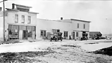
Wilder was founded in 1885.[7] It was named for Amherst Holcomb Wilder, a railroad official.[8] Wilder was incorporated as a city in 1899.[8] A post office was established in Wilder in 1886, and remained in operation until it was discontinued in 1991.[9]
Geography
According to the United States Census Bureau, the city has a total area of 0.81 square miles (2.10 km2), of which 0.80 square miles (2.07 km2) is land and 0.01 square miles (0.03 km2) is water.[10]
Minnesota State Highways 60 and 86 are two of the main routes in the community.
Demographics
| Historical population | |||
|---|---|---|---|
| Census | Pop. | %± | |
| 1900 | 174 | — | |
| 1910 | 95 | −45.4% | |
| 1920 | 91 | −4.2% | |
| 1930 | 97 | 6.6% | |
| 1940 | 127 | 30.9% | |
| 1950 | 118 | −7.1% | |
| 1960 | 107 | −9.3% | |
| 1970 | 132 | 23.4% | |
| 1980 | 120 | −9.1% | |
| 1990 | 83 | −30.8% | |
| 2000 | 69 | −16.9% | |
| 2010 | 60 | −13.0% | |
| 2019 (est.) | 57 | [3] | −5.0% |
| U.S. Decennial Census[11] | |||
2010 census
As of the census[2] of 2010, there were 60 people, 25 households, and 16 families residing in the city. The population density was 75.0 inhabitants per square mile (29.0/km2). There were 28 housing units at an average density of 35.0 per square mile (13.5/km2). The racial makeup of the city was 100.0% White.
There were 25 households, of which 24.0% had children under the age of 18 living with them, 48.0% were married couples living together, 8.0% had a female householder with no husband present, 8.0% had a male householder with no wife present, and 36.0% were non-families. 32.0% of all households were made up of individuals, and 16% had someone living alone who was 65 years of age or older. The average household size was 2.40 and the average family size was 3.00.
The median age in the city was 38 years. 28.3% of residents were under the age of 18; 0.1% were between the ages of 18 and 24; 25% were from 25 to 44; 28.4% were from 45 to 64; and 18.3% were 65 years of age or older. The gender makeup of the city was 56.7% male and 43.3% female.
2000 census
As of the census[4] of 2000, there were 69 people, 29 households, and 20 families residing in the city. The population density was 87.0 people per square mile (33.7/km2). There were 33 housing units at an average density of 41.6 per square mile (16.1/km2). The racial makeup of the city was 100.00% White.
There were 29 households, out of which 27.6% had children under the age of 18 living with them, 51.7% were married couples living together, 10.3% had a female householder with no husband present, and 31.0% were non-families. 20.7% of all households were made up of individuals, and 10.3% had someone living alone who was 65 years of age or older. The average household size was 2.38 and the average family size was 2.70.
In the city, the population was spread out, with 18.8% under the age of 18, 13.0% from 18 to 24, 18.8% from 25 to 44, 34.8% from 45 to 64, and 14.5% who were 65 years of age or older. The median age was 44 years. For every 100 females, there were 109.1 males. For every 100 females age 18 and over, there were 124.0 males.
The median income for a household in the city was $41,875, and the median income for a family was $41,563. Males had a median income of $27,143 versus $18,438 for females. The per capita income for the city was $14,222. There were 7.4% of families and 11.8% of the population living below the poverty line, including 15.8% of under eighteens and none of those over 64.
Politics
Wilder is located in Minnesota's 1st congressional district, represented by Republican Jim Hagedorn. At the state level, Wilder is located in Senate District 22, represented by Republican Doug Magnus, and in House District 22B, represented by Republican Rod Hamilton.
References
- "2019 U.S. Gazetteer Files". United States Census Bureau. Retrieved July 26, 2020.
- "U.S. Census website". United States Census Bureau. Retrieved 2012-11-13.
- "Population and Housing Unit Estimates". United States Census Bureau. May 24, 2020. Retrieved May 27, 2020.
- "U.S. Census website". United States Census Bureau. Retrieved 2008-01-31.
- "US Board on Geographic Names". United States Geological Survey. 2007-10-25. Retrieved 2008-01-31.
- "2010 Census Redistricting Data (Public Law 94-171) Summary File". American FactFinder. United States Census Bureau. Retrieved 27 April 2011.
- Chicago and North Western Railway Company (1908). A History of the Origin of the Place Names Connected with the Chicago & North Western and Chicago, St. Paul, Minneapolis & Omaha Railways. p. 196.
- Upham, Warren (1920). Minnesota Geographic Names: Their Origin and Historic Significance. Minnesota Historical Society. p. 263.
- "Jackson County". Jim Forte Postal History. Retrieved 5 April 2015.
- "US Gazetteer files 2010". United States Census Bureau. Retrieved 2012-11-13.
- "Census of Population and Housing". Census.gov. Retrieved June 4, 2015.
Municipalities and communities of Jackson County, Minnesota, United States | ||
|---|---|---|
| Cities | 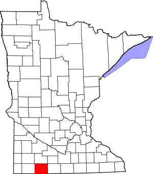 Map of Minnesota highlighting Jackson County | |
| Townships | ||
| CDP | ||
| Unincorporated communities | ||
| ||