Winnetoon, Nebraska
Winnetoon is a village in Knox County, Nebraska, United States. The population was 68 at the 2010 census.[6]
Winnetoon, Nebraska | |
|---|---|
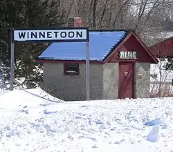 Winnetoon's historic jail, built in 1907, is now part of a park at the northwestern edge of the village. | |
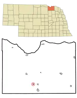 Location of Winnetoon, Nebraska | |
| Coordinates: 42°30′47″N 97°57′42″W | |
| Country | United States |
| State | Nebraska |
| County | Knox |
| Area | |
| • Total | 0.29 sq mi (0.75 km2) |
| • Land | 0.29 sq mi (0.75 km2) |
| • Water | 0.00 sq mi (0.00 km2) |
| Elevation | 1,660 ft (506 m) |
| Population | |
| • Total | 68 |
| • Estimate (2019)[3] | 66 |
| • Density | 227.59/sq mi (87.80/km2) |
| Time zone | UTC-6 (Central (CST)) |
| • Summer (DST) | UTC-5 (CDT) |
| ZIP code | 68789 |
| Area code(s) | 402 |
| FIPS code | 31-53345[4] |
| GNIS feature ID | 0834820[5] |
History
Winnetoon was founded circa 1892 and was incorporated as a village in 1900.[7] It was named after the Wisconsin farm of an acquaintance of a railroad official.[8][9]
A post office has been in operation in Winnetoon since 1891.[10][11]
Geography
Winnetoon is located at 42°30′47″N 97°57′42″W (42.513146, -97.961729).[12]
According to the United States Census Bureau, the village has a total area of 0.29 square miles (0.75 km2), all land.[13]
Demographics
| Historical population | |||
|---|---|---|---|
| Census | Pop. | %± | |
| 1910 | 220 | — | |
| 1920 | 208 | −5.5% | |
| 1930 | 159 | −23.6% | |
| 1940 | 141 | −11.3% | |
| 1950 | 120 | −14.9% | |
| 1960 | 85 | −29.2% | |
| 1970 | 84 | −1.2% | |
| 1980 | 82 | −2.4% | |
| 1990 | 59 | −28.0% | |
| 2000 | 70 | 18.6% | |
| 2010 | 68 | −2.9% | |
| 2019 (est.) | 66 | [3] | −2.9% |
| U.S. Decennial Census[14] | |||
2010 census
As of the census[2] of 2010, there were 68 people, 31 households, and 20 families living in the village. The population density was 234.5 inhabitants per square mile (90.5/km2). There were 40 housing units at an average density of 137.9 per square mile (53.2/km2). The racial makeup of the village was 95.6% White and 4.4% Native American.
There were 31 households, of which 16.1% had children under the age of 18 living with them, 58.1% were married couples living together, 3.2% had a female householder with no husband present, 3.2% had a male householder with no wife present, and 35.5% were non-families. 25.8% of all households were made up of individuals, and 6.5% had someone living alone who was 65 years of age or older. The average household size was 2.19 and the average family size was 2.70.
The median age in the village was 51.5 years. 17.6% of residents were under the age of 18; 4.4% were between the ages of 18 and 24; 16.1% were from 25 to 44; 48.5% were from 45 to 64; and 13.2% were 65 years of age or older. The gender makeup of the village was 54.4% male and 45.6% female.
2000 census
As of the census[4] of 2000, there were 70 people, 33 households, and 22 families living in the village. The population density was 243.6 people per square mile (93.2/km2). There were 37 housing units at an average density of 128.8 per square mile (49.3/km2). The racial makeup of the village was 100.00% White.
There were 33 households, out of which 21.2% had children under the age of 18 living with them, 48.5% were married couples living together, 18.2% had a female householder with no husband present, and 33.3% were non-families. 30.3% of all households were made up of individuals, and 21.2% had someone living alone who was 65 years of age or older. The average household size was 2.12 and the average family size was 2.64.
In the village, the population was spread out, with 20.0% under the age of 18, 1.4% from 18 to 24, 25.7% from 25 to 44, 30.0% from 45 to 64, and 22.9% who were 65 years of age or older. The median age was 46 years. For every 100 females, there were 100.0 males. For every 100 females age 18 and over, there were 93.1 males.
As of 2000 the median income for a household in the village was $19,000, and the median income for a family was $20,625. Males had a median income of $25,625 versus $22,083 for females. The per capita income for the village was $13,270. There were 18.2% of families and 15.2% of the population living below the poverty line, including 35.3% of under eighteens and none of those over 64.
References
- "2019 U.S. Gazetteer Files". United States Census Bureau. Retrieved July 26, 2020.
- "U.S. Census website". United States Census Bureau. Retrieved 2012-06-24.
- "Population and Housing Unit Estimates". United States Census Bureau. May 24, 2020. Retrieved May 27, 2020.
- "U.S. Census website". United States Census Bureau. Retrieved 2008-01-31.
- "US Board on Geographic Names". United States Geological Survey. 2007-10-25. Retrieved 2008-01-31.
- http://www.yankton.net/articles/2011/03/03/community/doc4d6f181b374f9967268554.txt
- "Winnetoon, Knox County". Center for Advanced Land Management Information Technologies. University of Nebraska. Retrieved 18 August 2014.
- Fitzpatrick, Lillian L. (1960). Nebraska Place-Names. University of Nebraska Press. p. 90. ISBN 0-8032-5060-6. A 1925 edition is available for download at University of Nebraska—Lincoln Digital Commons.
- Chicago and North Western Railway Company (1908). A History of the Origin of the Place Names Connected with the Chicago & North Western and Chicago, St. Paul, Minneapolis & Omaha Railways. p. 140.
- "Knox County". Jim Forte Postal History. Retrieved 18 August 2014.
- https://tools.usps.com/go/POLocatorAction!input.action
- "US Gazetteer files: 2010, 2000, and 1990". United States Census Bureau. 2011-02-12. Retrieved 2011-04-23.
- "US Gazetteer files 2010". United States Census Bureau. Retrieved 2012-06-24.
- "Census of Population and Housing". Census.gov. Retrieved June 4, 2015.
Municipalities and communities of Knox County, Nebraska, United States | ||
|---|---|---|
| Cities | Map of Nebraska highlighting Knox County | |
| Villages | ||
| Townships | ||
| CDP | ||
| Unincorporated communities | ||
| Indian reservations | ||
| ||
| Authority control |
|
|---|