Winnipeg RT
Winnipeg RT is a bus rapid transit system in Winnipeg, Manitoba, Canada, currently consisting of the Southwest Transitway, operated by Winnipeg Transit. Future expansions consisting of an Eastern Corridor connecting downtown to Transcona and a West-North Corridor connecting St. James with Downtown and West Kildonan are in the planning stages.
| Southwest Transitway | |
|---|---|
 Osborne Station | |
| Overview | |
| Operator | Winnipeg Transit |
| Garage | Fort Rouge |
| Began service | 8 April 2012 |
| Route | |
| Communities served | Downtown Winnipeg, Ft. Rouge, Ft. Garry, Ft. Richmond, St. Norbert |
| Start | Balmoral Station |
| End | University of Manitoba, St. Norbert |
| Stations | 16 |
History
The timeline of accomplishing some form of rapid transit in the Winnipeg area goes back decades, to the late 1950s, when the Greater Winnipeg Transit Commission hired a Toronto urban planner to design a subway for Winnipeg.
- The Future Development of the Greater Winnipeg Transit System recommended a 3 semi-circular lines intersecting at various points in the metro area.[1][2][3][4]Combined, these three rapid transit lines would have cost $449 M.
- During the 1960s when the Greater Winnipeg Development Plan was being written, the Metropolitan Corporation of Greater Winnipeg studied a future transit system for the region. In their report, Winnipeg Area Transportation Study: Projections & Recommendations (Vol. 3), a 5.4 mile (8.69 km) underground subway system between Polo Park Shopping Centre and Henderson and Hespeler Avenue in Elmwood was recommended.[5][6][7] The WATS study did computerized modelling for a bus only transit system, but found it woefully inadequate for a metro population of 781,000 in 1991.
The transit system visualized in this scheme would involve the introduction of 36 different transit routes totalling 622 route miles and requiring a fleet of 1,090 buses. Such an operation would ensure that, on the average, in the peak hours, buses in the metropolitan area would be spaced at 3.38 minute intervals along their routes. This compares with 6.43 minutes under the system in operation in 1962."
In 1972, Steve Juba, Mayor of Winnipeg from 1957-77, advocated for a suspended monorail operating along Portage Ave.[8][9] and later St. Vital. Juba said that it would be cheaper to construct than a subway. Cost estimates were $22 M for the completed project, or $1 M per mile. At the time, the only monorail operating in North America was the Seattle monorail. While Juba was away, Council held a vote on the monorail, which was lost.
- After Winnipeg amalgamated with its suburbs in 1972 and Winnipeg Transit was created, the newly created transit department completely changed its view on rapid transit, opting for Bus Rapid Transit instead, and changing where it should initially go to between downtown Winnipeg and the Fort Garry campus of the University of Manitoba. Deleuuw Dillon was hired to create a plan for bus rapid transit, now the Southwest Transit Corridor. However, politicians balked at the cost of any form of rapid transit — rail or bus, due to the very high initial construction costs. Dillon Consulting remains involved in planning for the SWBRT.
- In 2002, Mayor Glen Murray pushed for BRT as the mode choice for the Southwest Transit Corridor using guided bus technology like that in the Essen, Germany. He made a deal with Premier Gary Doer that would see the construction of the Kenaston Underpass, the construction of the Manitoba Hydro headquarters downtown, and the construction of Phase I of the Corridor.[10] All projects except the BRT were funded and constructed. Glen Murray quit his job as Mayor to run for a seat in the 2004 Federal election, which he lost.
- The next Mayor, Sam Katz, promised to cancel a $43 million federal grant for the Southwest Transit Corridor and use that for improving recreation centres.[11][12] At the same day of the September 29, 2004 vote on rapid transit, 25-year (1979–2004) veteran Transit Director Rick Borland quit the position and retired over the issue[13] when one of Katz's advisors, Bryan Gray, criticized a report by Winnipeg Transit used to request funding for the busway.[13]
- In November 2004, Katz visited Ottawa and rode the O-Train (now the Trillium Line). Katz commented "And it's new, it's innovative -- it's the 21st century. There's no reason in my mind that we shouldn't explore this."[14]
- Instead Katz formed an ad hoc group, chaired by Coun. Wyatt (Transcona), in the same ward that New Flyer has its manufacturing plant, to complete a study on the viability of LRT for Winnipeg, though Katz could not accomplish an LRT for Winnipeg. The Rapid Transit Task Force report was released in 2005.
- Tom Brodbeck, formerly a Winnipeg Sun columnist wrote in September 2004 that there had been no cost-benefit analysis of the BRT project.[12]
- As a compromise, Katz allowed Phase I of BRT that "could be converted to LRT at a later date". Papers were signed in September 2008, with construction beginning during the Summer of 2009.
- On April 8th 2012, Phase 1 of the Southwest Transitway opened.
- On April 12th 2020, Phase 2 of the Southwest Transitway will be opened.
Southwest Transitway
Phase 1
Phase 1 of the Southwest Transitway commenced operation on April 8th, 2012.[15] The first section runs parallel to the railway tracks in a southwest direction from Queen Elizabeth Way (near The Forks) to Pembina Highway at Jubilee Avenue. Bus rapid transit services through the Downtown Winnipeg area will use the Graham Avenue Transit Mall and other bus priority routes.
Jubilee Station was the last one to be constructed and was completed on June 21, 2015.[16] It had a construction budget of C$3.9 million, with costs shared between the City (43%) and developer Gem Equities (57%). Due to cost overruns, Jubilee Station's actual cost was C$8.8 million after construction. The City owed more than C$1.3 million back to Gem to equalize the shared costs.[16]
Funding was approved for the planned extension of the transitway south from the Jubilee interchange to Bison Drive and the University of Manitoba.[17] A funding announcement was made in February 2015,[18] construction began in late 2016, project completion in Fall of 2019. Driver testing commenced in the Fall of 2019. Service to begin (tentatively) April 8, 2020.[19]
By 2018, although Winnipeg Transit has done its best to mitigate pigeon droppings at Osborne Station, it continues to be a problem at that location.[20] Winnipeg Transit sought advice from Orkin Canada who recommended using OvoControl P in nearby bird feeders to control the pigeon population.[20]
Phase 2
Phase 2 of the Southwest Transitway commenced operation on April 12th, 2020. Phase 2 of the project saw the Transitway extended from the Jubilee Overpass, through the Parker Lands and the Manitoba Hydro ROW before joining the CNR Lettelier line north of Bishop Grandin Boulevard. The Transitway then goes through Waverley Heights to Markham Road, where BLUE buses continue to the University of Manitoba or to St. Norbert
In March 2019, Winnipeg Transit introduced a new route structure, which begun at the opening of Phase 2 (April 12th, 2020). Previously, the SWBRT operated as an "Open Busway" design. The new routing is "Spine & Feeder" which is similar in functionality to rail-transit lines.[21] Switching to "Spine & Feeder" meant that WT has significantly changed its ideology since 1973, when it began promoting BRT, as the "Open Busway" ensured a "one-seat ride" and "spine & feeder may require a transfer to and from a feeder bus in the Fort Garry, Fort Richmond, and St. Norbert communities. The advantage of the spine & feeder design is there will be fewer buses entering the downtown area, being delayed by traffic congestion on downtown streets and along the Graham Avenue Transit Mall and as a result there will be less wear and tear on affected roadways.
Parker Station has been put on hold, pending legal settlements. It will be part of a future single-family and multi-family neighbourhood, Fulton Grove, situated within the Parker lands planning area. The station will be located between the extisting Jubilee and Beaumont stations.[22]
Stations

| Station | Routes | Description |
|---|---|---|
| Balmoral Station | BLUE, 42, 46, 48, 49 | The renovated former Winnipeg Bus Depot, located at Balmoral Street next to the University of Winnipeg, is the downtown terminus for rapid transit routes. |
| Harkness Station | BLUE, 47, 65, 66, 68, 635 | Located at the intersection of Harkness and Stradbrook Avenues. Entry and exit point of transitway to local roads to and from downtown. Also, a transfer point for Route 68. |
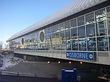
| Osborne Station | BLUE, 47, 65, 66 | Designed by architectural and landscape company ft3[23] was constructed on a bridge over Osborne Street near Osborne Junction. This station is the only covered station on the Southwest Transitway. Entry and exit point to Warsaw Avenue south of the station for Routes 65, and 66. According to CoW documents, Osborne Station cost upwards of $30 M when completed. |
| Fort Rouge Station | BLUE, 47, 95 | Located in the Fort Rouge Yards area off Morley Avenue. Transfers can be made to Route 95 with service to Riverview and Grant Park/Pan Am Pool, Shaftesbury Park and Polo Park. |
| Jubilee Station | BLUE, 47 | Is a station just northeast of the Pembina/Jubilee underpass. It opened June 21, 2015,[16] and includes geothermal heating to clear the platform of snow and ice.[24] Directly across the tracks is a retail area comprising Dollar Tree, Salisbury House Restaurant. |
| Beaumont Station | BLUE, 29, 641, 677 | Located north of Parker Avenue, between Beaumont and Georgina. Connections to/from Pembina Highway can be made with Route 29, and to/from Waverley Street with Routes 641 and 677. |
| Seel Station | BLUE, 642, 650, 690, 691, 694 | Located at the east end of Seel Avenue |
| Clarence Station | BLUE, 690, 691 | Located north of Clarence Avenue, between Marshall and Irene |
| Chevrier Station | BLUE, 649 (Street Only), 691 | Located north of Chevrier Boulevard, between French and Hervo. Connections to/from Pembina Highway can be made with Route 649. |
| Plaza Station | BLUE | Located at the west end of Plaza Drive |
| Chancellor Station | BLUE, 676 (Street Only), 693 (Street Only) | Located north and south of Chancellor Drive, between Gaylene and Gull Lake. Connections to/from Pembina Highway can be made with Route 676. |
| Southpark Station | BLUE (U of M), 662, 693 | On-street stop located on Southpark Drive, northeast of Markham Station |
| Stadium Station | BLUE (U of M) | Located at the east end of Bohemier Trail |
| University of Manitoba Station | BLUE (U of M), 36, 47, 60, 74, 75, 78, 662, 671, 672 | On-street stop located on Dafoe Road on the University of Manitoba grounds |
| Markham Station | BLUE (St. Norbert), 662, 693 | Located at the south end of the Southwest Transitway |
| St. Norbert Station | BLUE (St. Norbert), 91 | On-street stop located on Pembina Highway in St. Norbert |
Routes
| Route Number/Name | Description |
|---|---|
| BLUE | Service between Downtown and the U of Manitoba or St. Norbert, via the Southwest Transitway |
| 47 Transcona – Pembina | Service between Transcona and the U of Manitoba, via Phase 1 of the SWT. Only stops at Harkness, Osborne, Fort Rouge and Jubilee Station |
| 65 Grant Express | Service between City Hall and Ridgewood, via Phase 1 of the SWT. Only stops at Harkness and Osborne Station (Peak Hours Only) |
| 66 Grant | Service between City Hall and Polo Park or Unicity/Dieppe (no service to Unicity on Sunday/Holidays), via Phase 1 of the SWT. Only stops at Harkness and Osborne Station |
| 635 Osborne Village | Service between Harkness Station and Misericordia Health Center |
| 641 Lindenwoods West | Service between Beaumont Station and the Kenaston Common shopping area |
| 642 Lindenwoods East | Service between Seel Station and Winnipeg Technical College |
| 649 Chevrier | Service between Windermere and Whyte Ridge, via Chevrier Station |
| 650 McGillivray | Service between Seel Station and Whyte Ridge |
| 662 Richmond | Service between Markham Station and the University of Manitoba |
| 671 Dalhousie | Service between the University of Manitoba and Prairie Pointe |
| 672 Killarney | Service between the University of Manitoba and Prairie Pointe |
| 676 Bridgwater/River Road | Service between St. Vital Centre and Bridgwater, via Chancellor Station |
| 677 Wilkes | Service between Beaumont Station and Outlet Collection. Service extended to the Kenaston Common shopping area during weekday peak hours. |
| 690 Industrial | Service between Seel Station and Kenaston, via Clarence (peak hours only) |
| 691 Whyte Ridge | Service between Seel Station and Whyte Ridge, via Chevrier (peak hours only) |
| 693 Waverley Heights | Service between Markham Station and Bridgwater Forest, via Chancellor (peak hours only) |
| 694 Wildwood | Service between Seel Station and Hamelin, via Wildwood Park (peak hours only) |
Project Financing
Financing Phase 2's estimated $590 M cost will be split three ways: Province $225M, Federal $140M, City $225M.[25]
Of the City's share, $19.7M will have to be budgeted annually for the Project, starting in 2020. Raising the revenue to pay their fair share, one or a combination of "the allocation of cash-to-capital funding, a property tax increase, a transit fare increase, or a combination of these options.", according to the Dillon report of 2014.
Other Related Works
The CoW used the Phase 2 project as an opportunity to rebuild and expand the Jubilee Underpass, which has a history of flooding during heavy rainfalls in the Summer. Storm drains are being upgraded to prevent flooding.
The CN Portage Junct. Overpass, constructed in 1948 was replaced by a modern structure in 2018.
Eastern Transitway
The eastern corridor is a planned bus rapid transit line from downtown Winnipeg to Transcona.
Alignment Options
St. Boniface Option - the line would cross the red river near Shaw Park and go through North St.Boniface and Whittier Park, crossing Archibald Street and going through the Mission Industrial Park terminating near Kildonan Place Shopping Centre.[26]
Point Douglas Option - the line would see improvements to Higgins Avenue and a transit only bridge crossing the Red River, going through the Mission Industrial Park terminating near Kildonan Place Shopping Centre.[26]
Further public consultations on routing options will take place in October 2019, as no firm decisions have been made.[27] However, since then further planning and decision-making on the Eastern Corridor has been put on hold, commensurate with the release of the Final Draft of the Transit Master Plan, expected Winter 2020.[28]
North-West Transitway
The north-west corridor is a proposed bus rapid transit line that would use either the median or curb lanes along Portage Avenue from Polo Park to downtown, continuing on Main Street all the way to Inkster Boulevard in West Kildonan.
Airport Link
The airport link is a proposed bus rapid transit link connecting Winnipeg James Armstrong Richardson International Airport to the North-West Corridor.
References
- "Expert to Study Subway for Winnipeg". The Winnipeg Tribune. August 14, 1958.
- "Subway Report Highlights". The Winnipeg Tribune. April 11, 1959.
- "Cost Estimated At $449 Million". The Winnipeg Tribune. April 11, 1959.
- "3 Routes Suggested For City". The Winnipeg Tribune. April 11, 1959. pp. 1, 3.
- "Metro transportation study: The dream of a subway". The Winnipeg Tribune. January 24, 1969. p. 17.
- Jones, Mel (February 28, 1969). "Metro announces plan for rapid transportation". The Winnipeg Tribune. p. 1.
- "Subway system advocated". The Winnipeg Tribune. November 9, 1970. p. 2.
- Mackay, Douglas (March 23, 1972). "Monorail Transit for City Studied". Winnipeg Free Press. p. 1.
- Werier, Val (March 28, 1972). "Does Winnipeg need a monorail?". The Winnipeg Tribune. p. 6.
- Welch, Mary Agnes (July 12, 2004). "Katz flips on fast transit". Winnipeg Free Press. pp. A1–A2.
- Welch, Mary Agnes (September 25, 2004). "Rec-centre cash in limbo". Winnipeg Free Press. p. B1.
- Brodbeck, Tom (September 10, 2004). "Forget rapid transit". The Winnipeg Sun. p. 5.
- Brodbeck, Tom (September 25, 2004). "Remember Who's The Boss". The Winnipeg Sun. p. 5.
- Romaniuk, Ross (November 20, 2004). "Katz considers LRT". The Winnipeg Sun.
- "It's a rapid Transitway, not a sidewalk: city". The Winnipeg Sun. January 11, 2012.
- Botelho-Urbanski, Jessica (2018-01-24). "Jan 2018: City discussing rapid transit station's tab". Winnipeg Free Press. Retrieved 2020-02-10.
- "BRT should reach U of M by 2016: Gerbasi". The Winnipeg Sun. November 15, 2011.
- "Governments commit funding to Winnipeg's rapid transit extension". CBC News Manitoba. February 9, 2015. Retrieved October 31, 2019.
- Dawkins, Glen (October 29, 2019). "Transit proposes faster, more reliable service in southwest Winnipeg". The Winnipeg Sun. Retrieved October 30, 2019.
- "'It's everywhere': Riders disgusted by pigeon-poop covered surfaces at Osborne transit station". Global News. Retrieved 2020-02-10.
- "Winnipeg Transit - SW Transitway Routes". Winnipeg Transit. Retrieved September 16, 2019.
- Kavanagh, Sean (May 29, 2020). "Winnipeg city council holds off on controversial Polo Park and Parker Lands developments". CBC News Manitoba.
- "ft3 Architecture Landscape Interior Design | Projects". www.ft3.ca. Retrieved 2020-02-10.
- Kives, Bartley (July 18, 2015). "Bumps on the road: The future of the city's rapid transit rests on residential infill, but it hasn't been a smooth journey for developers". Winnipeg Free Press.
- "City report lays out plan for Phase 2 of Winnipeg rapid transit". CBC Manitoba. May 21, 2014. Retrieved April 24, 2019.
- Kives, Bartley (October 28, 2011). "City plan calls for four rapid transit corridors by 2031". Winnipeg Free Press.
- Macintosh, Maggie (September 9, 2019). "Winnipeg bus rapid transit consultation likely in October". Winnipeg Free Press.
- "Eastern Corridor Study". winnipegtransit.com. Retrieved 2020-01-27.
Further reading
- The Future Development of the Greater Winnipeg Transit System. Norman D. Wilson. March 1959
- Winnipeg Area Transportation Study (WATS): Volume 3 - Projections & Recommendations. Metropolitan Corporation of Greater Winnipeg. September 1968.
- The (Non) History of Rapid Transit in Winnipeg. City Magazine. Jeff Lowe. Spring 1985.
- Direction to the Future. Winnipeg Transit. 2000.
- Rapid Transit Task Force. City of Winnipeg. 2005.
- Pembina Highway Underpass Study. City of Winnipeg. 2012.
- Southwest Transitway Route Planning. Winnipeg Transit. July 2019.
