Winnipeg Route 52
Route 52 is a major north-south arterial route in Winnipeg, Manitoba, Canada. It comprises all of Main Street, Queen Elizabeth Way, and St. Mary's Road.
| ||||
|---|---|---|---|---|
| Main Street Queen Elizabeth Way St. Mary's Road | ||||
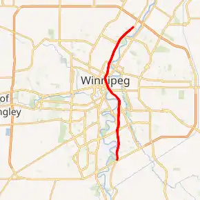
Route 52 highlighted in red | ||||
| Route information | ||||
| Maintained by City of Winnipeg | ||||
| Length | 21.2 km[1] (13.2 mi) | |||
| Existed | 1966–present | |||
| Known for | Junction of Portage and Main | |||
| Component highways | PTH 1 (Trans-Canada Highway) | |||
| Major junctions | ||||
| North end | PTH 9 north / Winnipeg city limits | |||
| ||||
| South end | PTH 100 (TCH) (Perimeter Hwy) / PR 200 south (St. Mary's Rd) | |||
| Highway system | ||||
| Manitoba provincial highways Winnipeg City Routes
| ||||

Route description
Beginning at the northern city limits, the route runs south as Main Street along the west bank of the Red River. After passing through downtown, it becomes the Queen Elizabeth Way from the Main Street Bridge to the Norwood Bridge, over the Assiniboine and Red Rivers. South of the Norwood Bridge, it continues along the east side of the river as St. Mary's Road to the south Perimeter Highway. At the northern city limits, Route 52 becomes Manitoba Highway 9; at the south Perimeter Highway, it continues as Manitoba Provincial Road 200.
Route 52 passes through the suburbs of West Kildonan, the North End, Downtown, Fort Rouge, St. Boniface, and St. Vital. The section between Broadway and St. Anne's Road is part of Manitoba Highway 1, the Trans-Canada Highway.
Many of Winnipeg's most prominent buildings and institutions are located along Main Street, including City Hall, the Centennial Concert Hall, the Manitoba Museum, Union Station, the Richardson Building, and 360 Main (formerly the Commodities Exchange tower).
History
Main Street is one of the oldest routes in the Winnipeg region. It originated as the trail between Lower Fort Garry and the various settlements huddled around the confluence of the Red and Assiniboine Rivers. Its intersection with the Portage Trail near Upper Fort Garry (now downtown Winnipeg) spawned the Portage and Main corner, which is today the heart of the city. Upper Fort Garry was eventually demolished by the city in order to straighten the southern portion of Main Street and realign it to its current configuration. The north gate, the sole surviving piece of Upper Fort Garry, stands near the corner of Broadway and Main.[2]
St. Mary's Road is named after St. Mary's Parish (Ste. Marie Paroisse in French), a Roman Catholic parish located in the northernmost section of St. Vital.[3] It was originally a trail that led from the parish south to the United States border at Emerson along the east side of the Red River. In rural Manitoba, St. Mary's Road is now incorporated into Provincial Roads 200 and 246.
A short section of Main Street was renamed Queen Elizabeth Way to commemorate the 2002 Royal Visit of Queen Elizabeth II to the city.[4]
Photo gallery
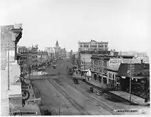 Main Street in 1887 (at Pioneer Avenue, looking north)
 Looking north on Main Street at St. Mary Avenue
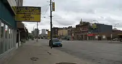 Main Street at Jarvis Avenue, looking south towards downtown
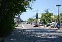 St. Mary's Road at Carriere Avenue, looking north toward downtown
Major intersections
From north to south:[5]
| Street Name | Location | km[1] | mi | Destinations | Notes |
|---|---|---|---|---|---|
| R.M. West St. Paul | −1.1 | −0.68 | Interchange; PTH 101 exit 71 | ||
| Main Street | West Kildonan | 0.0 | 0.0 | Winnipeg city limits | Continues as PTH 9 |
| 2.0 | 1.2 | ||||
| 3.3 | 2.1 | One-way westbound east of Main Street | |||
| 3.4 | 2.1 | One-way eastbound (no access, T-intersection) | |||
| 5.1 | 3.2 | Inkster Boulevard | |||
| 6.4 | 4.0 | ||||
| Downtown | 7.8 | 4.8 | Higgens Avenue | ||
| 8.1 | 5.0 | ||||
| 8.2 | 5.1 | No southbound to eastbound exit; Alexander Avenue is one-way, westbound; north end of Route 42 east concurrency | |||
| 8.4 | 5.2 | One-way eastbound (no access, T-intersection); south end of Route 42 east concurrency | |||
| 8.6 | 5.3 | Bannatyne Avenue | One-way, westbound | ||
| 8.7 | 5.4 | McDermot Avenue | One-way, eastbound | ||
| 8.9 | 5.5 | See Portage and Main Eastern terminus of Yellowhead Highway | |||
| 9.0 | 5.6 | Pioneer Avenue | One-way, westbound (no access, T-intersection) | ||
| 9.1 | 5.7 | One-way, eastbound | |||
| 9.2 | 5.7 | Graham Avenue | |||
| 9.3 | 5.8 | St. Mary Avenue | One-way, westbound | ||
| 9.5 | 5.9 | York Avenue – The Forks | One-way eastbound west of Main Street | ||
| 9.7 | 6.0 | North end of PTH 1 concurrency | |||
| Assiniboine River | 10.1– 10.2 | 6.3– 6.3 | Main Street Bridge Main Street south end • Queen Elizabeth Way north end | ||
| Queen Elizabeth Way | Fort Rouge | 10.2 | 6.3 | Mayfair Avenue | One-way eastbound (no access, T-intersection); northbound entrance from Stradbrook Avenue |
| 10.3 | 6.4 | River Avenue (via Stradbrook Avenue) | No northbound entrance; Stradbrook Avenue alignment, signed as River Avenue | ||
| Red River | 10.4– 10.6 | 6.5– 6.6 | Norwood Bridge Queen Elizabeth Way south end • St. Mary's Road north end | ||
| St. Mary's Road | St. Boniface | 10.7 | 6.6 | No northbound access | |
| 11.3 | 7.0 | Tache Avenue / Enfield Cresecent | Northbound access to Route 115 east | ||
| St. Vital | 13.1 | 8.1 | South end of PTH 1 concurrency | ||
| 14.4 | 8.9 | ||||
| 16.3 | 10.1 | ||||
| 16.9 | 10.5 | ||||
| 17.6 | 10.9 | Meadowood Drive – St. Vital Centre | |||
| 21.2 | 13.2 | Continues as PR 200 | |||
1.000 mi = 1.609 km; 1.000 km = 0.621 mi
| |||||
References
- Google (August 8, 2017). "Route 52 in Winnipeg" (Map). Google Maps. Google. Retrieved August 8, 2017.
- Botan, K. "A Short Pictorial History On Upper Ft. Garry". Lincoln Park Gallery.
- Winnipeg's Historic Sites and Monuments: An Illustrated Guide. City of Winnipeg Parks and Recreation Department. Published 1979.
- Goldsborough, Gordon. "MHS Resources: Queen Elizabeth II and Manitoba". Manitoba Historical Society.
- Sherlock Publishing (2016). Sherlock's Map of Winnipeg (Map) (20th ed.). Winnipeg: Sherlock Publishing. pp. 3–4, 9, 17, 25, 31. ISBN 1-895229-84-7.