Winnipeg Route 85
Route 85, also known as Portage Avenue, is a major arterial route in the city of Winnipeg, Manitoba, Canada. It is one of the city's oldest and most important roads and is part of both the Trans-Canada and Yellowhead Highways.
| ||||
|---|---|---|---|---|
| Portage Avenue | ||||
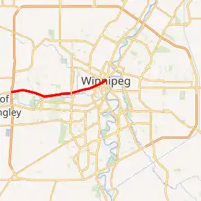
Route 85 highlighted in red | ||||
 Corner of Portage and Main as seen from eastbound Route 85 | ||||
| Route information | ||||
| Maintained by City of Winnipeg | ||||
| Length | 14.0 km[1] (8.7 mi) | |||
| Existed | 1966–present | |||
| Known for | Junction of Portage and Main | |||
| Component highways | PTH 1 (Trans-Canada Highway) Yellowhead Highway | |||
| Major junctions | ||||
| East end | Route 52 (Main St) / Route 57 | |||
| West end | PTH 100 (TCH) south / PTH 101 north (Perimeter Hwy) / PTH 1 (TCH) west | |||
| Highway system | ||||
| Manitoba provincial highways Winnipeg City Routes
| ||||


Route description

Route 85 begins in the heart of downtown Winnipeg, at the corner of Portage and Main (Route 52), and runs southwest through the downtown to Broadway. From Broadway to the west Perimeter Highway (PTH 100/101), it runs concurrently with the Trans-Canada Highway (PTH 1). Route 85 ends at the Perimeter Highway interchange, however, Portage Avenue and PTH 1 continue to the official city limit and into Headingley. Portage Avenue is also the first leg of the Yellowhead Highway from Winnipeg to Edmonton, which branches off PTH 1 on to PTH 16 near Portage la Prairie.
Route 85 is a six-lane road for its entire length and passes by major destinations such as Winnipeg Square, Bell MTS Place, Portage Place, Polo Park Shopping Centre, and the University of Winnipeg. It is also the main link (via Route 90) between the city's downtown and airport.[2]
Portage Avenue East, which extends approximately 200 meters southeast from the Portage and Main intersection to Westbrook Street near Shaw Park, is not part of Route 85 or the Yellowhead Highway.
History
The origin of the route stems from its use as a part of an old Red River ox cart trail.[3][4]
The (red river) carts left deep ruts in the soft prairie turf, so deep that the wagons tended to spread out, the right wheel of one cart travelling in the wake of the left wheel of the cart ahead; thus, the prairie trails could be as much as twenty carts wide, a phenomenon that helps explain the many broad streets in Winnipeg. Portage Avenue is the widest thoroughfare in Canada and was known as Queen Street during the period from 1891 to 1893 as part of a failed scheme to introduce a numbering scheme to Winnipeg's streets. It is actually part of the old trail that led west to Portage la Prairie and then on to Edmonton.
Major intersections
Major intersections for Route 85 starting from Westbrook Street and heading west to the Perimeter Highway.
| Location | km[1] | mi | Destinations | Notes | |
|---|---|---|---|---|---|
| Downtown | −0.2 | −0.12 | East end of Portage Avenue | ||
| 0.0 | 0.0 | See Portage and Main east end of Route 57 concurrency | |||
| 0.1 | 0.062 | West end of Route 57 westbound concurrency; one-way northbound (westbound) | |||
| 0.2 | 0.12 | Garry Street | One-way southbound | ||
| 0.3 | 0.19 | One-way northbound | |||
| 0.4 | 0.25 | One-way southbound | |||
| 0.5 | 0.31 | Hargave Street | One-way northbound | ||
| 0.6 | 0.37 | West end of Route 57 eastbound concurrency; one-way southbound (eastbound) | |||
| 0.7 | 0.43 | Edmonton Street | One-way, northbound (no access, T-intersection) | ||
| 0.8 | 0.50 | Kennedy Street | One-way southbound | ||
| 0.9 | 0.56 | Vaughan Street – Portage Place | One-way northbound | ||
| 1.0 | 0.62 | ||||
| West End | 1.2 | 0.75 | Balmoral Street – University of Winnipeg | ||
| 1.75 | 1.09 | One-way southbound | |||
| 1.8 | 1.1 | One-way northbound | |||
| 2.0 | 1.2 | East end of PTH 1 concurrency; no left turn (westbound) | |||
| 2.3 | 1.4 | Arlington Street – Vimy Ridge Memorial Park | |||
| 3.0 | 1.9 | Dominion Street – RCMP Division 'D' headquarters | |||
| 3.5 | 2.2 | Wall Street | One-way northbound | ||
| 3.7 | 2.3 | Erin Street | One-way southbound | ||
| 4.0 | 2.5 | Valour Road | |||
| 4.5 | 2.8 | Empress Street – Polo Park | Grade separated | ||
| 4.9 | 3.0 | St. James Street – Polo Park | No left turn (both directions) | ||
| St. James-Assiniboia | 5.0 | 3.1 | Interchange | ||
| 9.3 | 5.8 | ||||
| 10.7 | 6.6 | ||||
| 11.6 | 7.2 | Westwood Drive | |||
| 13.3 | 8.3 | Buchanan Boulevard | |||
| 13.7– 14.2 | 8.5– 8.8 | Interchange; signed as exits 318A (east) and 318B (north); | |||
1.000 mi = 1.609 km; 1.000 km = 0.621 mi
| |||||
See also
References
- Google (July 28, 2017). "Route 85 in Winnipeg" (Map). Google Maps. Google. Retrieved July 28, 2017.
- Vanderhart, Tessa. "Best intersection in Canada? Portage and Main nominated as one of Canada's Greatest Places". Winnipeg Sun. Retrieved October 26, 2014.
- "Things you might not know about Portage and Main". CBC News. Retrieved October 26, 2014.
- George F. Reynolds (October 26, 2014). "The Man Who Created the Corner of Portage and Main". Manitoba Historical Society. Retrieved October 26, 2014.