Antigo, Wisconsin
Antigo (/ˈæntɪˌɡoʊ/ AN-ti-goh)[5] is a city in and the county seat of Langlade County, Wisconsin, United States.[6] The population was 8,234 at the 2010 census. Antigo is the center of a farming and lumbering district, and its manufactures consist principally of lumber, chairs, furniture, sashes, doors and blinds, hubs and spokes, and other wood products.
Antigo | |
|---|---|
City | |
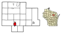 Location of Antigo in Langlade County, Wisconsin. | |
 Close-up of Antigo | |
| Coordinates: 45°8′28″N 89°9′12″W | |
| Country | United States |
| State | Wisconsin |
| County | Langlade |
| Founded | 1878 |
| Seat of Langlade County | 1880 |
| Government | |
| • Mayor | Bill Brandt[1] |
| Area | |
| • Total | 6.51 sq mi (16.86 km2) |
| • Land | 6.46 sq mi (16.72 km2) |
| • Water | 0.05 sq mi (0.14 km2) 0.91% |
| Elevation | 1,500 ft (500 m) |
| Population | |
| • Total | 8,234 |
| • Estimate (2019)[4] | 7,767 |
| • Density | 1,203.25/sq mi (464.58/km2) |
| Time zone | UTC-6 (CST) |
| • Summer (DST) | UTC-5 (CDT) |
| Zip Code | 54409 |
| Area code(s) | 715 & 534 |
| FIPS code | 55-02250 |
| Website | www.antigo-city.org |
History
The name "Antigo" comes from the Chippewa Indian name for the river that flows through the area, "Nequi-Antigo-sebi" meaning "spring river" or "evergreen."[7]
The city was founded in 1876[8][9] by Francis A. Deleglise,[10][11] accompanied by George Eckart.[12] The log cabin in which Deleglise lived is preserved and on display at the Langlade County Historical Society Museum.[13] A street in Antigo also bears his name. The city gained its charter in 1883.
In the early part of the 1900s, Antigo was best known for its sawmills. At the turn of the millennium, the city's economy had a balance of industry and agriculture. High on the list are potatoes, dairy products, fur, shoes, fertilizer, steel, and aluminum products, along with the lumber and wood product industries established in the earlier years.[14]
On April 24, 2016, a former Antigo High School student shot two students with a rifle during prom, wounding both. As he approached the school with a rifle a police officer who was already on the scene shot him. He later died at a Wausau hospital.[15][16]
Geography
Antigo is located at 45°8′28″N 89°9′12″W (45.141218, -89.153385),[17] about 160 miles (260 km) northwest of Milwaukee.
According to the United States Census Bureau, the city has a total area of 6.60 square miles (17.09 km2), of which, 6.54 square miles (16.94 km2) is land and 0.06 square miles (0.16 km2) is water.[18]
Antigo sits on a plateau about 1,500 feet (460 m) above sea level. The wide expanse of level land, the fine stand of timber and the fertility of the "Antigo Flats" soil soon attracted many settlers. Today the Antigo Silt Loam soil is the state soil of Wisconsin.
Climate
Antigo has a cool humid continental climate (Köppen Dfb). Annually the temperature drops below 32 °F (0 °C) on 187 days, and below 0 °F (−17.8 °C) on 43 days. The daily mean temperatures of the winters in this region are associated with subarctic climates with frequent subzero temperatures, but due to the extended warm period of daily means above 50 °F (10 °C) from May to September it stays within the humid continental temperature range.
| Climate data for Antigo, Wisconsin | |||||||||||||
|---|---|---|---|---|---|---|---|---|---|---|---|---|---|
| Month | Jan | Feb | Mar | Apr | May | Jun | Jul | Aug | Sep | Oct | Nov | Dec | Year |
| Record high °F (°C) | 60 (16) |
59 (15) |
78 (26) |
90 (32) |
100 (38) |
99 (37) |
101 (38) |
99 (37) |
94 (34) |
87 (31) |
73 (23) |
59 (15) |
101 (38) |
| Average high °F (°C) | 20.2 (−6.6) |
26.1 (−3.3) |
35.5 (1.9) |
52.4 (11.3) |
66.6 (19.2) |
74.9 (23.8) |
79.0 (26.1) |
76.4 (24.7) |
66.5 (19.2) |
55.0 (12.8) |
38.3 (3.5) |
24.6 (−4.1) |
51.3 (10.7) |
| Daily mean °F (°C) | 9.8 (−12.3) |
15.1 (−9.4) |
27.0 (−2.8) |
41.4 (5.2) |
53.9 (12.2) |
62.6 (17.0) |
67.0 (19.4) |
64.9 (18.3) |
55.4 (13.0) |
44.4 (6.9) |
29.9 (−1.2) |
15.6 (−9.1) |
40.6 (4.8) |
| Average low °F (°C) | −0.7 (−18.2) |
4.1 (−15.5) |
16.9 (−8.4) |
30.3 (−0.9) |
41.2 (5.1) |
50.2 (10.1) |
54.9 (12.7) |
53.4 (11.9) |
44.3 (6.8) |
33.8 (1.0) |
21.4 (−5.9) |
6.5 (−14.2) |
29.7 (−1.3) |
| Record low °F (°C) | −39 (−39) |
−40 (−40) |
−23 (−31) |
−2 (−19) |
17 (−8) |
26 (−3) |
30 (−1) |
30 (−1) |
13 (−11) |
5 (−15) |
−14 (−26) |
−35 (−37) |
−40 (−40) |
| Average precipitation inches (mm) | 0.87 (22) |
0.78 (20) |
1.64 (42) |
2.61 (66) |
3.01 (76) |
3.67 (93) |
3.96 (101) |
4.23 (107) |
4.02 (102) |
2.60 (66) |
2.07 (53) |
1.17 (30) |
30.63 (778) |
| Average snowfall inches (cm) | 13.8 (35) |
9.1 (23) |
9.5 (24) |
4.1 (10) |
0.5 (1.3) |
0 (0) |
0 (0) |
0 (0) |
0 (0) |
1.0 (2.5) |
7.3 (19) |
14.6 (37) |
59.9 (152) |
| Source: Midwestern Regional Climate Center[19] | |||||||||||||
Demographics
| Historical population | |||
|---|---|---|---|
| Census | Pop. | %± | |
| 1890 | 4,424 | — | |
| 1900 | 5,145 | 16.3% | |
| 1910 | 7,196 | 39.9% | |
| 1920 | 8,451 | 17.4% | |
| 1930 | 8,610 | 1.9% | |
| 1940 | 9,495 | 10.3% | |
| 1950 | 9,902 | 4.3% | |
| 1960 | 9,691 | −2.1% | |
| 1970 | 9,005 | −7.1% | |
| 1980 | 8,653 | −3.9% | |
| 1990 | 8,276 | −4.4% | |
| 2000 | 8,560 | 3.4% | |
| 2010 | 8,234 | −3.8% | |
| 2019 (est.) | 7,767 | [4] | −5.7% |
| U.S. Decennial Census[20] | |||
2010 census
As of the census[3] of 2010, there were 8,234 people, 3,613 households, and 2,049 families residing in the city. The population density was 1,259.0 inhabitants per square mile (486.1/km2). There were 3,972 housing units at an average density of 607.3 per square mile (234.5/km2). The racial makeup of the city was 95.1% White, 0.5% African American, 1.4% Native American, 0.4% Asian, 0.8% from other races, and 1.7% from two or more races. Hispanic or Latino of any race were 2.7% of the population.
There were 3,613 households, of which 28.5% had children under the age of 18 living with them, 39.3% were married couples living together, 12.6% had a female householder with no husband present, 4.8% had a male householder with no wife present, and 43.3% were non-families. 37.1% of all households were made up of individuals, and 17.1% had someone living alone who was 65 years of age or older. The average household size was 2.21 and the average family size was 2.88.
The median age in the city was 40.6 years. 23.5% of residents were under the age of 18; 8.2% were between the ages of 18 and 24; 23% were from 25 to 44; 26.2% were from 45 to 64; and 19.1% were 65 years of age or older. The gender makeup of the city was 47.9% male and 52.1% female.
2000 census
As of the census[21] of 2000, there were 8,560 people, 3,630 households, and 2,221 families residing in the city. The population density was 1,328.7 people per square mile (513.2/km2). There were 3,938 housing units at an average density of 611.3 per square mile (236.1/km2). The racial makeup of the city was 97.27% White, 0.30% Black or African American, 0.86% Native American, 0.29% Asian, 0.01% Pacific Islander, 0.32% from other races, and 0.95% from two or more races. 1.20% of the population were Hispanic or Latino of any race.
There were 3,630 households, out of which 29.3% had children under the age of 18 living with them, 46.0% were married couples living together, 11.7% had a female householder with no husband present, and 38.8% were non-families. 34.1% of all households were made up of individuals, and 18.1% had someone living alone who was 65 years of age or older. The average household size was 2.29 and the average family size was 2.93.
In the city, the population was spread out, with 24.6% under the age of 18, 8.2% from 18 to 24, 25.7% from 25 to 44, 20.4% from 45 to 64, and 21.2% who were 65 years of age or older. The median age was 39 years. For every 100 females, there were 89.0 males. For every 100 females age 18 and over, there were 83.5 males.
The median income for a household in the city was $29,548, and the median income for a family was $40,883. Males had a median income of $29,932 versus $20,156 for females. The per capita income for the city was $16,592. About 10.2% of families and 13.2% of the population were below the poverty line, including 15.8% of those under age 18 and 12.2% of those age 65 or over.
Transportation
Highways
| U.S. 45 Northbound US 45 routes to Eagle River, Wisconsin. Southbound, US 45 routes to Wittenberg, Wisconsin. | |
| WIS 47 splits off U.S. 45 5 miles (8.0 km) south of Antigo then runs south to Shawano, Wisconsin and runs north concurrent with U.S. 45 to Rhinelander, Wisconsin. | |
| WIS 52 travels east to Wabeno, Wisconsin and west to Wausau, Wisconsin. | |
| WIS 64 travels east to Marinette, Wisconsin and west to Merrill, Wisconsin. |
Airport
Antigo is served by the Langlade County Airport (KAIG). Located two miles northeast of the city, the airport handles approximately 8,250 operations per year, with roughly 97% general aviation, 2% air taxi and 1% military. The airport has a 4,010 foot asphalt runway with approved GPS approaches (Runway 17-35) and a 3,400 foot asphalt crosswind runway with GPS approaches (Runway 9-27).[22]
Education
Public schools in Antigo are administered by the Antigo Unified School District. Public schools within the city include: East Elementary School, North Elementary School, West Elementary School, Antigo Middle School, Antigo High School, and AIMS Academy.
In addition, there are two parochial schools in Antigo: Peace Lutheran School(K-8) and All Saints Catholic School (K-8).
Athletics
Antigo's high school football team won Division 1 state championships in 1976, 1978 and 1982. It also won three state titles prior to the introduction of the WIAA tournament system in 1976. From 1920 to 2007, the school won 23 Wisconsin Valley Conference championships and six state titles from 1970–1982, including seven seasons in which the team did not lose a game.[23]
Culture
The Langlade County Museum is housed in the 1902 Carnegie library building on the corner of 7th Avenue and Superior Street. The building housed the Antigo Public Library from 1905 to 1997. The museum contains historical artifacts and archives of Langlade County and the City of Antigo.[24]
Recreation
In Antigo and the surrounding area recreational activities include fishing, hunting, swimming, snowmobiling. The Kettlebowl ski area, in nearby Bryant, Wisconsin, provides downhill and cross country skiing opportunities. The Midwest Collegiate Hockey Association is in Antigo.
The Clara R McKenna Aquatic Center opened in 2005 on the site of Antigo High School, offers Antigo area residents a year-round recreation pool and lap pool.
The Langlade County fairgrounds, located in Antigo, has an indoor ice rink in winter and facilities for off-road racing and demolition derbies in summer. As well as Friday night Stockcar races, the National Anthem starts at 7 pm.
Notable people
- James A. Barker, Wisconsin State Senator
- Clayton Bailey, sculptor
- Justin Berg, Chicago Cubs pitcher
- James Bradley, son of John Bradley, author of Flags of Our Fathers and Flyboys: A True Story of Courage
- John Bradley, Navy corpsman who took part in the Raising the Flag on Iwo Jima
- Walter D. Cavers, Wisconsin State Representative
- James Randall Durfee, U.S. federal court judge
- Clair Finch, Wisconsin State Representative and lawyer
- Charles Gowan, former Antigo Mayor
- Jon Hohman, professional football player
- Paul E. Knapp, U.S. Air Force Major General, Wisconsin State Adjutant General
- George W. Latta, Wisconsin State Representative
- Alfred J. Lauby, Wisconsin State Representative
- D. Wayne Lukas, U.S. Racing Hall of Fame horse trainer
- Thomas Lynch, U.S. Representative
- Francis J. McCormick, NFL player
- Elmer Addison Morse, U.S. Representative
- Thomas D. Ourada, Wisconsin State Representative
- Joe Piskula, Nashville Predators defenseman
- Burt W. Rynders, Wisconsin State Representative and Mayor of Antigo
- Ray Szmanda, radio and television personality/spokesperson
- Margaret Turnbull, astronomer, graduate of Antigo High School
- James M. Vande Hey, U.S. Air Force general
- Clair H. Voss, Presiding Judge of the Wisconsin Court of Appeals
- Clarence E. Wagner, Mayor of Long Beach, California
- Eli Waste, Wisconsin State Representative
- Sarah Waukau, Wisconsin State Representative
Images
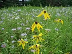 Native prairie grasses and flowers in Antigo
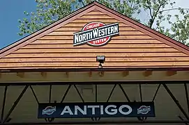 Antigo stop on the Chicago and Northwestern Railroad.
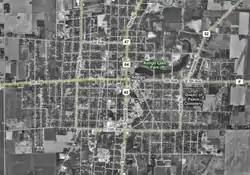
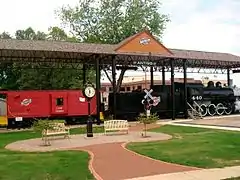 Northwestern Railroad Park
 Road sign for Antigo
References
- Mayor Welcome Message. City of Antigo.
- "2019 U.S. Gazetteer Files". United States Census Bureau. Retrieved August 7, 2020.
- "U.S. Census website". United States Census Bureau. Retrieved 2012-11-18.
- "Population and Housing Unit Estimates". United States Census Bureau. May 24, 2020. Retrieved May 27, 2020.
- Webster's New Geographical Dictionary (G. & C. Merriam Co., 1972), p. 57.
- "Find a County". National Association of Counties. Archived from the original on 2011-05-31. Retrieved 2011-06-07.
- Chicago and North Western Railway Company (1908). A History of the Origin of the Place Names Connected with the Chicago & North Western and Chicago, St. Paul, Minneapolis & Omaha Railways. p. 37.
- "Antigo's Pioneer is Dead". Oshkosh Daily Northwestern. 14 June 1914. p. 1. Retrieved August 10, 2014 – via Newspapers.com.

- Washington, William Penn. 1976. Antigo Centennial, 1876-1976: City of Antigo, Wisconsin. Antigo: Washington-Penn Publishing Company.
- "To Erect Memorial to City's Founder". Oshkosh Daily Northwestern. 15 March 1928. p. 7. Retrieved August 10, 2014 – via Newspapers.com.
- "Antigo Honors Founder of City". The Capital Times. 14 June 1928. p. 5. Retrieved August 10, 2014 – via Newspapers.com.
- Leitermann, C. Luke. 1930. History of St. John the Evangelist Church, Antigo, Wisconsin: Golden Jubilee, 1880-1930. Antigo: Berner Brothers, p. 18.
- The Langlade County Historical Society-Deleglise Cabin
- Langlade County Historical Society
- Jonathan Anderson and Nathan Vine. ""18-year-old gunman dead after shooting 2 students at northern Wisconsin prom". Milwaukee Journal Sentinel, April 24, 2016.
- Eliott C. McLaughlin. "Suspect in Wisconsin prom shooting dies, police say". CNN, April 24, 2016.
- "US Gazetteer files: 2010, 2000, and 1990". United States Census Bureau. 2011-02-12. Retrieved 2011-04-23.
- "US Gazetteer files 2010". United States Census Bureau. Archived from the original on 2012-01-25. Retrieved 2012-11-18.
- "Climate of the Midwest: Climate Summaries". Midwestern Regional Climate Center. 2012. Archived from the original on 2014-06-30. Retrieved on October 1, 2012.
- "Census of Population and Housing". Census.gov. Retrieved June 4, 2015.
- "U.S. Census website". United States Census Bureau. Retrieved 2008-01-31.
- http://www.airnav.com/airports/kaig
- http://www.wihsfb.com/history.htm
- Langlade Historical Society
External links
| Wikimedia Commons has media related to Antigo, Wisconsin. |
- City of Antigo
- Antigo Public Library
- Sanborn fire insurance maps: 1889 1892 1898 1904 1909 1919
Municipalities and communities of Langlade County, Wisconsin, United States | ||
|---|---|---|
| City | 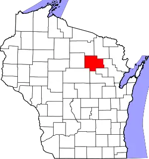 | |
| Village | ||
| Towns | ||
| CDPs | ||
| Unincorporated communities | ||
| Ghost towns/neighborhoods |
| |
| ||
| Authority control |
|---|