Woody Point, Queensland
Woody Point is a coastal suburb of Redcliffe in the Moreton Bay Region, Queensland, Australia.[2] In the 2016 census, Woody Point had a population of 4,418 people.[1]
| Woody Point Redcliffes, Queensland | |||||||||||||||
|---|---|---|---|---|---|---|---|---|---|---|---|---|---|---|---|
.jpg.webp) Scotts Point Beach at Woody Point | |||||||||||||||
 | |||||||||||||||
 Woody Point | |||||||||||||||
| Coordinates | 27.2544°S 153.1016°E | ||||||||||||||
| Population | 4,418 (2016 census)[1] | ||||||||||||||
| • Density | 2,600/km2 (6,730/sq mi) | ||||||||||||||
| Established | 1971 | ||||||||||||||
| Postcode(s) | 4019 | ||||||||||||||
| Area | 1.7 km2 (0.7 sq mi) | ||||||||||||||
| Time zone | AEST (UTC+10:00) | ||||||||||||||
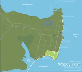
| Location |
| ||||||||||||||
| LGA(s) | Moreton Bay Region | ||||||||||||||
| State electorate(s) | Redcliffe | ||||||||||||||
| Federal Division(s) | Petrie | ||||||||||||||
| |||||||||||||||
Along with its neighbouring coastal suburbs on the Redcliffe Peninsula, the suburb is a popular recreational destination within the Brisbane metropolitan area.
Geography
.jpg.webp)
Woody Point is at the south-east of the Redcliffe Peninsula, approximately 35.2 kilometres (21.9 mi) by roadnorth-northeast of Brisbane, the state capital of Queensland, Australia.
The suburb is bounded by Moreton Bay to the east, Bramble Bay to the south, roughly by unnamed drain to the west and roughly by King Street to the north.[3]
There are three headlands along the eastern coast of the suburb. At the southern tip is Woody Point (27.2630°S 153.1038°E), also known as Ningeryoun, first marked on a 1840s survey map by James Charles Burnett.[4] Further north are:
- Picnic Point (27.2614°S 153.1077°E)[5]
- Scotts Point (27.2547°S 153.1102°E), which was probably named after surgeon Peter Walter Scott who was the storekeeper in Moreton Bay penal settlement between 1824 to 1926.[6]
History
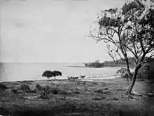
In 1799, Matthew Flinders landed on the peninsula and named the location Red Cliff Point after the colours in the cliffs. In 1823 the peninsula was selected as the site of Queensland's first (and only) penal colony (Moreton Bay penal settlement) but, after arriving in 1824 to establish the colony, problems with mosquitoes and the resistance from local Aboriginals caused the colony tp relocate up the Brisbane River in 1825, founding the city of Brisbane.
Redcliffe developed s small seaside retreat accessibly only by boat from Brisbane while Woody Point was originally a banana plantation.
Woody Point Jetty was built in 1888. It was reconstructed during 2008 at a cost of $9.6 million.[7]
When the Hornibrook Bridge opened in 1935 (later replaced by the Houghton Highway and Ted Smout Memorial Bridge ), it linked Brighton, the most north-eastern suburb in the City of Brisbane, across Hays Inlet to Clontarf on the Redcliffe Peninsula. By improving the road connection between them, Redcliffe then became much more accessible and grew as part of Brisbane's suburban sprawl.
Our Lady of Lourdes School opened on 1969 and closed on 1995.[8]
Woody Point Special School opened on 21 August 1978.[8]
Southern Cross Catholic College (Woody Point Primary) opened on 2002, being formed by the amalgamation of 3 catholic primary schools of the Peninsula, Brigidine College and De La Salle College.[8]
In 1958, HMQS Gayundah was run aground at Woody Point to create a breakwater.[9]
The foundation stone of St Mark's Anglican Church was laid at 46 Kate Street (corner of Annie Street, 27.2577°S 153.1070°E) on Sunday 26 April 1953 by Archbishop Reginald Halse.[10][11] The church was dedicated on 7 April 1957 by Archbishop Halse. It was consecrated on 28 April 1968 by Archbishop Philip Strong. In the 1990s it was decided to combine the congregations of St Mark's and St Barbanas' in Clontarf into a new St Peter the Fisherman's Anglican Church at Clontarf. This led to the closure of St Mark's on 24 April 1993 which was approved by Assistant Bishop George Browning.[12] St Peter the Fisherman's was dedicated in 1993.[13] As at July 2020, the St Mark's site has been converted into a multi-unit dwelling but the foundation stone is still visible on the street corner.[14]
Woody Point's Apex Park & Bicentennial Park were constructed by reclaiming land along the foreshore in the 1970s.
In the 2016 census, Woody Point had a population of 4,418 people.[1]
Heritage listings
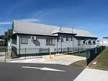
Heritage-listed sites at Woody Point including Woody Point Memorial Hall along the Hornibrook Esplanade (27.26°S 153.1036°E.[15]
Amenities
Woody Point's current renovations include the construction of high-rise apartment buildings overlooking Bramble Bay, Moreton Bay, The Port of Brisbane and the Ted Smout Highway. Until recently, restaurants and cafes were very limited in the suburb, however currently Woody Point boasts some of the most highly rated and recognised restaurants on the Redcliffe Peninsula including The Steak & Crabhouse & Masala Point Cafe.
The closest shopping centre is either Margate Village, some 2 km north or Bayside Plaza in Clontarf, some 3 km southwest. Woody Point accommodates localized convenience retail, a corner store, takeaways, a medical clinic and pharmacy & an Australian Post branch within its Woody Point Village.
The Clontarf branch of the Queensland Country Women's Association meets at the corner of Victoria Avenue and Georgina Street (27.2554°S 153.0973°E).[16]
Bramble Bay Bowls Club is on the corner of Hornibrook Esplanade and Victoria Avenue (27.2561°S 153.0974°E).[17][18]
Eildon Croquet Club is on the corner of the Hornibrook Esplanade and Oxley Avenue (27.2594°S 153.1033°E).[19]
Other clubs on the point include the Redcliffe Outrigger Canoe Club and Humpybong Yacht Club.
Education
Southern Cross Catholic College is a private primary (Prep-6) campus at 84 Collins Street, Woody Point (27.2504°S 153.0983°E) of the Southern Cross Catholic College (headquartered at Scarborough) .[20][21]
Woody Point Special School is a special primary and secondary (Early Childhood-12) school for boys and girls at 85 Georgina Street (27.2557°S 153.1005°E).[20][22] In 2018, the school had an enrolment of 86 students with 33 teachers (25 full-time equivalent) and 48 non-teaching staff (33 full-time equivalent).[23] It offers an early childhood special education program.[20][24]
The nearest government primary schools are Humpybong State School in neighbouring Margate to the north and Clontarf Beach State School in neighbouring Clontarf to the west. The nearest government secondary school is Clontarf Beach State High School at Clontarf.[3]
Attractions
Woody Point Jetty is a 240-metre (790 ft) jetty at the point Woody Point (27.2650°S 153.1024°E) with informative displays, seating and facilities for fishing.[7]
The remains of the HMQS Gayundah (27.2620°S 153.1072°E) can be seen at Picnic Point.[9][25]
- Bramble Bay foreshore including Bicentennial Park and Apex Park.
- Launching point for fishing boats and the Humpybong yacht club.
- Scott's Point and Gayundah coastal arboretum.
- Bells Creek
- Crockatt Park featuring BBQ and picnic area and great kids playground.
Demographics
In the 2011 census, Woody Point recorded a population of 4,089 people, 51.5% female and 48.5% male. The median age of the Woody Point population was 46 years, 9 years above the national median of 37. 71.5% of people living in Woody Point were born in Australia. The other top responses for country of birth were England 6.3%, New Zealand 6.3%, Scotland 1.2%, South Africa 0.9%, Canada 0.6%. 89.3% of people spoke only English at home; the next most common languages were 0.6% Spanish, 0.4% Russian, 0.4% German, 0.4% French, 0.3% Dutch.[26]
References
- Australian Bureau of Statistics (27 June 2017). "Woody Point (SSC)". 2016 Census QuickStats. Retrieved 20 October 2018.

- "Woody Point – suburb in Moreton Bay Region (entry 45499)". Queensland Place Names. Queensland Government. Retrieved 19 September 2020.
- "Queensland Globe". State of Queensland. Retrieved 13 October 2020.
- "Woody Point – point in Moreton Bay Regional (entry 38015)". Queensland Place Names. Queensland Government. Retrieved 19 September 2020.
- "Picnic Point – point in Moreton Bay Regional (entry 26640)". Queensland Place Names. Queensland Government. Retrieved 19 September 2020.
- "Scotts Point – point in Moreton Bay Regional (entry 30151)". Queensland Place Names. Queensland Government. Retrieved 19 September 2020.
- "New jetty completes before Christmas". Moreton Living December - January 2009. Moreton Bay Region. 1 December 2008.
- Queensland Family History Society (2010), Queensland schools past and present (Version 1.01 ed.), Queensland Family History Society, ISBN 978-1-921171-26-0
- "HMQS Gayundah Redcliffe shipwreck near Brisbane". Visit Moreton Bay Region. Archived from the original on 13 October 2020. Retrieved 13 October 2020.
- "DONATION OF ORGAN TO CHURCH". Maryborough Chronicle (25, 331). Queensland, Australia. 8 May 1953. p. 6. Archived from the original on 13 October 2020. Retrieved 28 July 2020 – via National Library of Australia.
- "St Mark's Anglican Church - Former". Churches Australia. Archived from the original on 28 July 2020. Retrieved 28 July 2020.
- "Closed Churches". Closed Anglican Churches of Southern Queensland. Archived from the original on 3 April 2019. Retrieved 3 April 2019.
- "St Peter the Fisherman Anglican Church Lucinda Street, Clontarf". Organ Historical Trust of Australia. Archived from the original on 18 September 2020. Retrieved 18 September 2020.
- Google (28 July 2020). "Former St Mark's Anglican Church, headstone on corner" (Map). Google Maps. Google. Retrieved 28 July 2020.
- "Woody Point Memorial Hall (entry 602828)". Queensland Heritage Register. Queensland Heritage Council. Retrieved 1 August 2014.
- "Branch Locations". Queensland Country Women's Association. Archived from the original on 26 December 2018. Retrieved 26 December 2018.
- "Bramble Bay Bowls Club". Archived from the original on 13 October 2020. Retrieved 13 October 2020.
- "Contact Us Bramble Bay Bowls Club". Archived from the original on 13 October 2020. Retrieved 13 October 2020.
- "Croquet Queensland : Eildon Croquet Club, Woody Point". Croquet Queensland. Archived from the original on 13 October 2020. Retrieved 13 October 2020.
- "State and non-state school details". Queensland Government. 9 July 2018. Archived from the original on 21 November 2018. Retrieved 21 November 2018.
- "Southern Cross Catholic College". Archived from the original on 15 January 2019. Retrieved 21 November 2018.
- "Woody Point Special School". Archived from the original on 18 April 2012. Retrieved 21 November 2018.
- "ACARA School Profile 2018". Australian Curriculum, Assessment and Reporting Authority. Archived from the original on 27 August 2020. Retrieved 28 January 2020.
- "Woody Point SPEC S - Early Childhood Development Program". Archived from the original on 18 April 2012. Retrieved 21 November 2018.
- "Visit Woody Point Jetty". Visit Moreton Bay Region. Archived from the original on 13 October 2020. Retrieved 13 October 2020.
- Australian Bureau of Statistics (31 October 2012). "Woody Point (Redcliffe City) (State Suburb)". 2011 Census QuickStats. Retrieved 13 October 2007.
External links
| Wikimedia Commons has media related to Woody Point, Queensland. |
- "Woody Point". Queensland Places. Centre for the Government of Queensland, University of Queensland.