Wyoming Highway 220
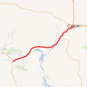
Wyoming Highway 220 (WYO 220) is the principal highway connecting the city of Casper to US 287/WYO 789. WYO 220 lies in northwestern Carbon and southern Natrona counties and along the famous Oregon Trail.[1]
| |||||||
|---|---|---|---|---|---|---|---|
| Alcova Highway | |||||||
WYO 220 highlighted in red | |||||||
| Route information | |||||||
| Maintained by WYDOT, City of Casper | |||||||
| Length | 72.79 mi[1] (117.14 km) | ||||||
| Existed | 1938–present | ||||||
| Major junctions | |||||||
| West end | |||||||
| East end | |||||||
| Location | |||||||
| Counties | Carbon, Natrona | ||||||
| Highway system | |||||||
State highways in Wyoming
| |||||||

Route description
Wyoming Highway 220 begins its western end in Carbon County at US 287/WYO 789 at Muddy Gap Junction and from there heads northeast toward Casper.[1] Nearing 20 miles, Highway 220 leaves Carbon County and enters Natrona County as it nears the north side of the Pathfinder Reservoir and the Pathfinder National Wildlife Refuge.[2] WYO 220 passes north of the reservoir, now traveling more easterly as it comes upon the census-designated place (CDP) of Alcova, the center of population of Wyoming. Also to the south lies Alcova Lake. Past Alcova, WYO 220 turns back northeast and begins to parallel the North Platte River and continue until it reaches Casper. At 53.17 miles the northern terminus of Wyoming Highway 487 is intersected as 220 continues northeast.[2] Just before entering the Casper city limits, the two-lane highway becomes a divided multi-lane highway with two lanes for each direction of traffic, and becomes known as CY Avenue. Wyoming Highway 258 (Wyoming Boulevard) is intersected at just over 69 miles. Past WYO 258, the multi-lane division continues until just before the intersection of CY Avenue and Poplar Street. At this intersection, WYO 220 follows Poplar Street north.[2] As WYO 220 heads north on Poplar Avenue, US 20 Business/US 26 Business (First Street) is intersected within a mile and three-quarters of a mile later, WYO 220 reaches its eastern end at Interstate 25 (exit 188B) which also carries US 20/US 26/US 87 as well.
The highway is maintained by WYDOT, except for portions of CY Avenue and Poplar Street in Casper, which are maintained locally.
History
Between 1926 and 1938, what is now WYO 220 was part of U.S. Route 87E (US 87E). In 1938, US 87E's portion in Wyoming was redesignated as WYO 220. Since then, there have been few routing changes except that it was connected to I-25 when the interstate was completed through Casper[1][3]
Major intersections
| County | Location | mi | km | Destinations | Notes |
|---|---|---|---|---|---|
| Carbon | Muddy Gap | 0.000 | 0.000 | Western terminus; highway continues as US 287/WYO 789 south | |
| Natrona | | 53.170 | 85.569 | Northern terminus of WYO 487 | |
| | 63.915 | 102.861 | Southern terminus of WYO 257; opened in December 2015 | ||
| Casper | 69.260 | 111.463 | |||
| 72.120 | 116.066 | ||||
| 72.790 | 117.144 | Eastern terminus; exit 188B on I-25; road continues north as Poplar Street | |||
| 1.000 mi = 1.609 km; 1.000 km = 0.621 mi | |||||
References
- aaroads.com - Wyoming Routes 200-299
- Google (13 November 2016). "Wyoming Highway 220" (Map). Google Maps. Google. Retrieved 13 November 2016.
- "Wyoming State Route 220". AARoads.com.
External links
| Wikimedia Commons has media related to Wyoming Highway 220. |
