Natrona County, Wyoming
Natrona County is a county in the U.S. state of Wyoming. As of the 2010 United States Census, the population was 75,450,[2] making it the second-most populous county in Wyoming. Its county seat is Casper.[3]
Natrona County | |
|---|---|
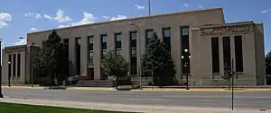 Natrona County Courthouse in Casper | |
 Flag | |
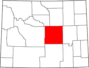 Location within the U.S. state of Wyoming | |
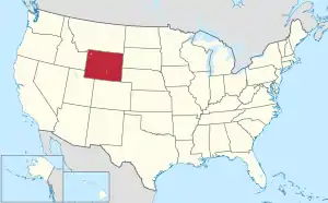 Wyoming's location within the U.S. | |
| Coordinates: 42°58′N 106°48′W | |
| Country | |
| State | |
| Named for | Natron deposits |
| Seat | Casper |
| Largest city | Casper |
| Area | |
| • Total | 5,376 sq mi (13,920 km2) |
| • Land | 5,340 sq mi (13,800 km2) |
| • Water | 35 sq mi (90 km2) 0.7%% |
| Population (2010) | |
| • Total | 75,450 |
| • Estimate (2019)[1] | 79,858 |
| • Density | 14/sq mi (5.4/km2) |
| Time zone | UTC−7 (Mountain) |
| • Summer (DST) | UTC−6 (MDT) |
| Congressional district | At-large |
| Website | www |
Natrona County comprises the Casper, WY Metropolitan Statistical Area.
In 2010, the center of population of Wyoming was in Natrona County, near Alcova.[4]
History
Prior to Wyoming's settlement by European-based populations, the area's stretches played host to nomadic tribes such as Cheyenne, Arapaho, Shoshone, and Sioux. The memory of such populations is represented at present by such preserves as the Wind River Indian Reservation, a large tract NW of Natrona County that serves as home to some 6,000 Shoshone and Arapaho tribal members.
New York investor John Jacob Astor established the settlement of Astoria on the Columbia River, and sent Robert Stuart eastward to blaze a trail and lay the foundation of a string of trading posts. Stuart documented the South Pass Route through the Continental Divide, near the SW corner of present-day Natrona County. Stuart's company erected the first hut in the area in 1812, near present-day Bessemer Bend. Other trappers and explorers used the route; some of them named Independence Rock in NW Natrona County on July 4, 1824.
In 1840, Father Pierre-Jean De Smet began preaching the Christian teaching to this area's indigenous peoples. He carved his name on Independence Rock and called it The Register of the Desert. Later explorers who inscribed the rock include John C. Frémont (1843), who explored the country along the Platte and Sweetwater Rivers.[5]
The first Euro-American settlement occurred in the Casper area in the late 19th century.[6] Natrona County was created by the legislature of the Wyoming Territory on March 9, 1888, and it was organized in 1890.[7] The land for Natrona County was annexed from Carbon County.
Natrona County was named for the deposits of natron found in the area.[8] In 1909, Natrona County gained land from Fremont County. The boundaries were adjusted slightly in 1911 and 1931, and at that point the county gained its present outline.
Geography
According to the US Census Bureau, the county has an area of 5,376 square miles (13,920 km2), of which 5,340 square miles (13,800 km2) is land and 35 square miles (91 km2) (0.7%) is water.[9]
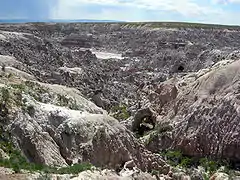
Geographic features
Adjacent counties
- Johnson County – north
- Converse County – east
- Albany County – southeast
- Carbon County – south
- Fremont County – west
- Washakie County – northwest
Major Highways
National protected areas
Demographics
| Historical population | |||
|---|---|---|---|
| Census | Pop. | %± | |
| 1890 | 1,094 | — | |
| 1900 | 1,785 | 63.2% | |
| 1910 | 4,766 | 167.0% | |
| 1920 | 14,635 | 207.1% | |
| 1930 | 24,272 | 65.8% | |
| 1940 | 23,858 | −1.7% | |
| 1950 | 31,437 | 31.8% | |
| 1960 | 49,623 | 57.8% | |
| 1970 | 51,264 | 3.3% | |
| 1980 | 71,856 | 40.2% | |
| 1990 | 61,226 | −14.8% | |
| 2000 | 66,533 | 8.7% | |
| 2010 | 75,450 | 13.4% | |
| 2019 (est.) | 79,858 | [10] | 5.8% |
| US Decennial Census[11] 1870–2000[12] 2010–2016[2] | |||
2000 census
As of the 2000 United States Census,[13] of 2000, there were 66,533 persons, 26,819 households, and 17,754 families in the county. The population density was 12 people per square mile (5/km2). There were 29,882 housing units at an average density of 6 per square mile (2/km2). The racial makeup of the county was 94.15% White, 0.76% Black or African American, 1.03% Native American, 0.42% Asian, 0.04% Pacific Islander, 1.92% from other races, and 1.68% from two or more races. 4.90% of the population were Hispanic or Latino of any race. 24.6% were of German, 11.6% English, 11.3% American and 11.2% Irish ancestry.
There were 26,819 households, out of which 32.20% had children under the age of 18 living with them, 51.40% were married couples living together, 10.60% had a female householder with no husband present, and 33.80% were non-families. 27.50% of all households were made up of individuals, and 9.40% had someone living alone who was 65 years of age or older. The average household size was 2.42 and the average family size was 2.95.
The county population contained 26.00% under the age of 18, 10.10% from 18 to 24, 27.90% from 25 to 44, 23.30% from 45 to 64, and 12.70% who were 65 years of age or older. The median age was 36 years. For every 100 females there were 97.70 males. For every 100 females age 18 and over, there were 95.00 males.
The median income for a household in the county was $36,619, and the median income for a family was $45,575. Males had a median income of $33,524 versus $21,374 for females. The per capita income for the county was $18,913. About 8.70% of families and 11.80% of the population were below the poverty line, including 16.20% of those under age 18 and 7.20% of those age 65 or over.
2010 census
As of the 2010 United States Census, there were 75,450 people, 30,616 households, and 19,714 families in the county.[14] The population density was 14.1 inhabitants per square mile (5.4/km2). There were 33,807 housing units at an average density of 6.3 per square mile (2.4/km2).[15] The racial makeup of the county was 92.8% white, 1.0% American Indian, 0.9% black or African American, 0.7% Asian, 0.1% Pacific islander, 2.2% from other races, and 2.4% from two or more races. Those of Hispanic or Latino origin made up 6.9% of the population.[14] In terms of ancestry, 27.2% were German, 15.2% were Irish, 13.2% were English, and 10.7% were American.[16]
Of the 30,616 households, 31.9% had children under the age of 18 living with them, 48.1% were married couples living together, 10.9% had a female householder with no husband present, 35.6% were non-families, and 28.5% of all households were made up of individuals. The average household size was 2.41 and the average family size was 2.94. The median age was 36.8 years.[14]
The median income for a household in the county was $50,936 and the median income for a family was $62,859. Males had a median income of $47,610 versus $30,664 for females. The per capita income for the county was $28,235. About 5.4% of families and 8.4% of the population were below the poverty line, including 9.9% of those under age 18 and 8.8% of those age 65 or over.[17]
Government
Like almost all of Wyoming, Natrona is a heavily Republican county. It is rather conservative for an urban county, having gone Republican in all but three elections since 1944. No Democratic presidential candidate has won forty percent of the county's vote since Lyndon Johnson garnered 52 percent in his 1964 landslide against Barry Goldwater. Bill Clinton did win a 100-vote plurality in the 1992 election due to a significant third-party vote. In 2020, Donald Trump received 71.8% of the vote, the county's highest vote percentage for any presidential candidate since Wyoming statehood in 1890.[18]
| Year | Republican | Democratic | Third parties |
|---|---|---|---|
| 2020 | 71.8% 25,271 | 24.2% 8,530 | 4.0% 1,401 |
| 2016 | 70.6% 23,552 | 19.7% 6,577 | 9.7% 3,219 |
| 2012 | 68.4% 22,132 | 27.7% 8,961 | 4.0% 1,280 |
| 2008 | 65.9% 21,906 | 31.5% 10,475 | 2.7% 886 |
| 2004 | 67.1% 21,512 | 30.8% 9,863 | 2.2% 693 |
| 2000 | 65.0% 18,439 | 30.5% 8,646 | 4.6% 1,303 |
| 1996 | 46.7% 13,182 | 39.8% 11,240 | 13.4% 3,793 |
| 1992 | 35.5% 9,717 | 35.8% 9,817 | 28.7% 7,866 |
| 1988 | 59.6% 14,005 | 39.0% 9,148 | 1.4% 334 |
| 1984 | 69.9% 18,488 | 28.7% 7,598 | 1.4% 378 |
| 1980 | 63.0% 16,801 | 26.7% 7,111 | 10.4% 2,760 |
| 1976 | 60.8% 13,761 | 38.2% 8,640 | 1.0% 220 |
| 1972 | 70.5% 15,649 | 29.3% 6,514 | 0.2% 37 |
| 1968 | 57.2% 10,679 | 31.6% 5,900 | 11.2% 2,095 |
| 1964 | 47.6% 10,135 | 52.4% 11,167 | |
| 1960 | 56.7% 11,809 | 43.3% 9,002 | |
| 1956 | 62.6% 10,796 | 37.4% 6,462 | |
| 1952 | 63.9% 10,663 | 36.1% 6,021 | 0.1% 11 |
| 1948 | 46.0% 5,341 | 53.3% 6,183 | 0.7% 84 |
| 1944 | 51.5% 5,196 | 48.5% 4,890 | |
| 1940 | 46.5% 5,555 | 53.3% 6,373 | 0.2% 21 |
| 1936 | 32.0% 3,810 | 65.7% 7,819 | 2.3% 278 |
| 1932 | 37.9% 4,368 | 58.8% 6,777 | 3.4% 388 |
| 1928 | 64.8% 7,141 | 34.6% 3,818 | 0.6% 64 |
| 1924 | 60.1% 8,267 | 11.9% 1,631 | 28.0% 3,857 |
| 1920 | 66.2% 2,957 | 25.8% 1,153 | 8.0% 357 |
| 1916 | 39.2% 912 | 59.2% 1,377 | 1.6% 38 |
| 1912 | 45.5% 640 | 31.8% 447 | 22.7% 319 |
| 1908 | 63.7% 835 | 35.2% 461 | 1.1% 14 |
| 1904 | 69.3% 738 | 30.1% 320 | 0.7% 7 |
| 1900 | 66.1% 520 | 33.9% 267 | |
| 1896 | 54.3% 392 | 45.3% 327 | 0.4% 3 |
| 1892 | 55.9% 194 | 44.1% 153 |
Natrona County is governed by a commission, based in the county seat of Casper. The five-member board consists of commissioners, elected to staggered four-year terms. Current commissioners are:
- Forrest Chadwick (Chairman) – Republican
- John Lawson (Vice-Chairman) – Republican
- Matt Keating – Republican
- Rob Hendry – Republican
- Steve Schlager – Republican
References
- Quick Facts 2018 Estimate
- "State & County QuickFacts". US Census Bureau. Archived from the original on June 6, 2011. Retrieved January 25, 2014.
- "Find a County". National Association of Counties. Retrieved June 7, 2011.
- "Centers of Population by State: 2010". US Census Bureau. Retrieved May 14, 2014.
- History of Natrona County (accessed 11 January 2019)
- "Email Validation". Newedc.net. Archived from the original on May 23, 2008. Retrieved January 9, 2018.
- Long, John H., ed. (2004). "Wyoming: Individual County Chronologies". Wyoming Atlas of Historical County Boundaries. The Newberry Library. Retrieved August 19, 2015.
- Urbanek, Mae (1988). Wyoming Place Names. Missoula MT: Mountain Press Pub. Co. ISBN 0-87842-204-8.
- "2010 Census Gazetteer Files". US Census Bureau. August 22, 2012. Retrieved August 18, 2015.
- "Population and Housing Unit Estimates". Census.gov. Retrieved September 28, 2019.
- "US Decennial Census". US Census Bureau. Retrieved August 18, 2015.
- "Historical Decennial Census Population for Wyoming Counties, Cities, and Towns". Wyoming Department of Administration & Information, Division of Economic Analysis. Retrieved January 25, 2014.
- "U.S. Census website". US Census Bureau. Retrieved May 14, 2011.
- "Profile of General Population and Housing Characteristics: 2010 Demographic Profile Data". US Census Bureau. Archived from the original on February 13, 2020. Retrieved January 12, 2016.
- "Population, Housing Units, Area, and Density: 2010 - County". US Census Bureau]]. Archived from the original on February 13, 2020. Retrieved January 12, 2016.
- "Selected Social Characteristics in the US – 2006-2010 American Community Survey 5-Year Estimates". US Census Bureau. Archived from the original on February 13, 2020. Retrieved January 12, 2016.
- "Selected Economic Characteristics – 2006-2010 American Community Survey 5-Year Estimates". US Census Bureau. Archived from the original on February 13, 2020. Retrieved January 12, 2016.
- Leip, David. "Atlas of US Presidential Elections". uselectionatlas.org. Retrieved January 9, 2018.
| Wikimedia Commons has media related to Natrona County, Wyoming. |
Places adjacent to Natrona County, Wyoming | ||||||||||
|---|---|---|---|---|---|---|---|---|---|---|
| ||||||||||
Municipalities and communities of Natrona County, Wyoming, United States | ||
|---|---|---|
| City | | |
| Towns | ||
| CDPs | ||
| Unincorporated communities | ||
| ||
| Authority control |
|---|