Casper, Wyoming
Casper is a city in, and the county seat of, Natrona County, Wyoming, United States.[8] Casper is the second largest city in the state, with the population was estimated at 57,931 as of 2019.[9] Only Cheyenne, the state capital, is larger. Casper is nicknamed "The Oil City" and has a long history of oil boomtown and cowboy culture, dating back to the development of the nearby Salt Creek Oil Field.
Casper, Wyoming | |
|---|---|
| City of Casper | |
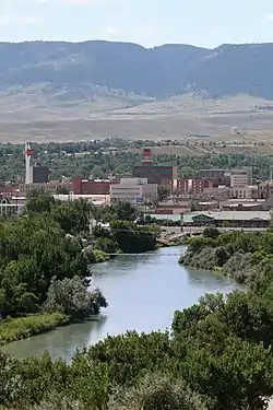 Overview of downtown, looking south toward Casper Mountain, with North Platte River in foreground | |
| Nickname(s): "The Oil City" | |
 Location within Natrona County | |
 Casper Location within Wyoming  Casper Location within the United States | |
| Coordinates: 42°51′0″N 106°19′30″W | |
| Country | |
| State | |
| County | |
| Government | |
| • Type | Council–manager[1] |
| • City Manager | Carter Napier[2] |
| Area | |
| • City | 26.88 sq mi (69.62 km2) |
| • Land | 26.55 sq mi (68.76 km2) |
| • Water | 0.33 sq mi (0.86 km2) |
| • Metro | 5,376 sq mi sq mi (13,923 km² km2) |
| Elevation | 5,150 ft (1,560 m) |
| Population | |
| • City | 55,316 |
| • Estimate (2019)[5] | 57,931 |
| • Rank | US: 601st |
| • Density | 2,182.21/sq mi (842.55/km2) |
| • Urban | 64,548 (US: 424th) |
| • Metro | 81,624 (US: 376th) |
| Time zone | UTC−7 (MST) |
| • Summer (DST) | UTC−6 (MDT) |
| ZIP Codes | 82601–82602, 82604–82605, 82609, 82615, 82630, 82638, 82646 |
| Area code(s) | 307 |
| FIPS code | 56-13150[6] |
| GNIS feature ID | 1586424[7] |
| Website | www.casperwy.gov |
Casper is located in east-central Wyoming at the foot of Casper Mountain, the north end of the Laramie Mountain Range, and along the North Platte River.
History
The city was established east of the former site of Fort Caspar, which was built during the mid-19th century mass migration of land seekers along the Oregon, California and Mormon trails.[10] The area was the location of several ferries that offered passage across the North Platte River in the early 1840s. In 1859, Louis Guinard built a bridge and trading post near the original ferry locations.[11]
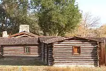
The government soon posted a military garrison nearby to protect telegraph and mail service. It was under the command of Lieutenant Colonel William O. Collins.[10] American Indian attacks increased after the Sand Creek Massacre in Colorado in 1864, bringing more troops to the post, which was by now called Platte Bridge Station. In July 1865, Lieutenant Caspar Collins (the son of Colonel Collins) was killed near the post by a group of Indian warriors. Three months later the garrison was renamed Fort Caspar after Lieutenant Collins.[10] In 1867, the troops were ordered to abandon Fort Caspar in favor of Fort Fetterman downstream on the North Platte along the Bozeman Trail.
The town of Casper itself was founded well after the fort had been closed. The city was founded by developers as an anticipated stopping point during the expansion of the Wyoming Central Railway; it was an early commercial rival to Bessemer and Douglas, Wyoming. The lack of a railhead doomed Bessemer in favor of Casper. Douglas, also a railhead, survives to the present day. The presence of a railhead made Casper the starting off point for the "invaders" in the Johnson County War. The special chartered train carrying the men up from Texas stopped at Casper. The town is named "Casper", instead of "Caspar", honoring the memory of Fort Caspar and Lt. Caspar Collins, due to a typo that occurred when the town's name was officially registered.
A site a few miles east was planned to be the original site of Casper,[12] where a homesteader named Joshua Stroud lived prior to a station of the Chicago and North Western Railway being built.[13][14][15] The site was laid out by the Pioneer Town Site Company in 1888 and was known as Strouds.
The city received a significant number of visitors during the solar eclipse of August 21, 2017, due to its position along the path of totality.[16]
Geography and climate
Interstate 25, which approaches Casper from the north and east, is the main avenue of transportation to and from the city. The towns immediately adjacent to Casper are Mills, Evansville, and Bar Nunn. Unincorporated areas include Allendale, Dempsey Acres, Red Buttes, Indian Springs, and several others.
According to the United States Census Bureau, the city has a total area of 27.24 square miles (70.55 km2), of which 26.90 square miles (69.67 km2) is land and 0.34 square miles (0.88 km2) is water.[17]
Casper, as with most of the rest of Wyoming, has a semi-arid climate (Köppen climate classification BSk), with long, cold, but dry winters, hot but generally dry summers, mild springs, and short and crisp autumns. Normal daily maxima range from 35 °F (1.7 °C) in January to 89 °F (31.7 °C) in July and August. Temperatures typically plummet during summer nights, with an average diurnal temperature variation approaching 35 °F (19.4 °C). Snow can fall heavily during the winter months, being the greatest in January, and usually falls in May and October, but rarely September. Precipitation is greatest in spring and early summer, but even then it is not high. Highs reach 90 °F (32.2 °C) on 31 days per year and fail to surpass freezing on 46. Lows drop to 0 °F (−17.8 °C) on an average of 18 nights annually.
| Climate data for Casper, Wyoming (1981–2010 normals,[lower-alpha 1] extremes 1939–present) | |||||||||||||
|---|---|---|---|---|---|---|---|---|---|---|---|---|---|
| Month | Jan | Feb | Mar | Apr | May | Jun | Jul | Aug | Sep | Oct | Nov | Dec | Year |
| Record high °F (°C) | 60 (16) |
68 (20) |
77 (25) |
84 (29) |
95 (35) |
102 (39) |
104 (40) |
102 (39) |
98 (37) |
87 (31) |
72 (22) |
65 (18) |
104 (40) |
| Mean maximum °F (°C) | 51.7 (10.9) |
55.9 (13.3) |
67.2 (19.6) |
76.9 (24.9) |
85.3 (29.6) |
94.5 (34.7) |
99.2 (37.3) |
96.9 (36.1) |
91.0 (32.8) |
78.8 (26.0) |
65.2 (18.4) |
52.0 (11.1) |
99.8 (37.7) |
| Average high °F (°C) | 35.2 (1.8) |
37.8 (3.2) |
47.9 (8.8) |
56.8 (13.8) |
67.1 (19.5) |
78.8 (26.0) |
88.1 (31.2) |
86.4 (30.2) |
74.3 (23.5) |
59.4 (15.2) |
44.7 (7.1) |
34.2 (1.2) |
59.3 (15.2) |
| Average low °F (°C) | 14.3 (−9.8) |
15.7 (−9.1) |
22.4 (−5.3) |
28.6 (−1.9) |
37.2 (2.9) |
45.7 (7.6) |
53.0 (11.7) |
51.5 (10.8) |
41.4 (5.2) |
31.0 (−0.6) |
21.6 (−5.8) |
13.5 (−10.3) |
31.4 (−0.3) |
| Mean minimum °F (°C) | −10.6 (−23.7) |
−10.0 (−23.3) |
3.1 (−16.1) |
14.5 (−9.7) |
25.0 (−3.9) |
35.4 (1.9) |
43.6 (6.4) |
41.0 (5.0) |
28.0 (−2.2) |
15.5 (−9.2) |
−1.8 (−18.8) |
−13.6 (−25.3) |
−21.5 (−29.7) |
| Record low °F (°C) | −40 (−40) |
−32 (−36) |
−21 (−29) |
−6 (−21) |
16 (−9) |
25 (−4) |
30 (−1) |
29 (−2) |
15 (−9) |
−9 (−23) |
−27 (−33) |
−41 (−41) |
−41 (−41) |
| Average precipitation inches (mm) | 0.51 (13) |
0.57 (14) |
0.82 (21) |
1.29 (33) |
2.02 (51) |
1.61 (41) |
1.41 (36) |
0.85 (22) |
1.08 (27) |
1.11 (28) |
0.76 (19) |
0.49 (12) |
12.52 (318) |
| Average snowfall inches (cm) | 9.1 (23) |
9.8 (25) |
10.9 (28) |
11.6 (29) |
2.9 (7.4) |
0.1 (0.25) |
0 (0) |
0 (0) |
1.8 (4.6) |
7.4 (19) |
10.3 (26) |
11.0 (28) |
74.9 (190) |
| Average precipitation days (≥ 0.01 in) | 6.1 | 6.9 | 8.5 | 10.2 | 11.2 | 9.3 | 7.7 | 6.2 | 6.9 | 7.6 | 6.9 | 7.2 | 94.7 |
| Average snowy days (≥ 0.1 in) | 6.5 | 7.4 | 7.7 | 6.2 | 1.7 | 0 | 0 | 0 | 0.7 | 4.2 | 6.3 | 7.7 | 48.4 |
| Mean daily sunshine hours | 6.0 | 7.0 | 8.0 | 9.0 | 9.0 | 11.0 | 11.0 | 10.0 | 9.0 | 7.0 | 6.0 | 5.0 | 8.2 |
| Percent possible sunshine | 67 | 64 | 67 | 69 | 60 | 73 | 73 | 71 | 75 | 64 | 60 | 56 | 67 |
| Average ultraviolet index | 2 | 2 | 4 | 6 | 8 | 9 | 10 | 9 | 7 | 4 | 2 | 1 | 5 |
| Source 1: NOAA[18][19] | |||||||||||||
| Source 2: Weather Atlas [20] | |||||||||||||
Demographics
| Historical population | |||
|---|---|---|---|
| Census | Pop. | %± | |
| 1880 | 40 | — | |
| 1890 | 544 | 1,260.0% | |
| 1900 | 883 | 62.3% | |
| 1910 | 2,639 | 198.9% | |
| 1920 | 11,447 | 333.8% | |
| 1930 | 16,619 | 45.2% | |
| 1940 | 17,964 | 8.1% | |
| 1950 | 23,673 | 31.8% | |
| 1960 | 38,930 | 64.4% | |
| 1970 | 39,361 | 1.1% | |
| 1980 | 51,016 | 29.6% | |
| 1990 | 46,742 | −8.4% | |
| 2000 | 49,644 | 6.2% | |
| 2010 | 55,316 | 11.4% | |
| 2019 (est.) | 57,931 | [21] | 4.7% |
| Source:[22][23] | |||
2010 census
As of the census[4] of 2010, there were 55,316 people, 22,794 households, and 14,237 families residing in the city. The population density was 2,056.4 inhabitants per square mile (794.0/km2). There were 24,536 housing units at an average density of 912.1 per square mile (352.2/km2). The racial makeup of the city was 92.3% White, 1.0% African American, 0.9% Native American, 0.8% Asian, 2.3% from other races, and 2.6% from two or more races. Hispanic or Latino people of any race were 7.4% of the population.
There were 22,794 households, of which 31.5% had children under the age of 18 living with them, 46.1% were married couples living together, 11.2% had a female householder with no husband present, 5.2% had a male householder with no wife present, and 37.5% were non-families. Of all households 30.3% were made up of individuals, and 10.1% had someone living alone who was 65 years of age or older. The average household size was 2.38 and the average family size was 2.95.
The median age in the city was 36 years. 23.9% of residents were under the age of 18; 10.2% were between the ages of 18 and 24; 26.7% were from 25 to 44; 26.4% were from 45 to 64; and 12.9% were 65 years of age or older. The gender makeup of the city was 49.7% male and 50.3% female.
2000 census
As of the census[6] of 2000, there were 49,644 people, 20,343 households, and 13,141 families residing in the city. The population density was 2,073.2 people per square mile (800.3/km2). There were 21,872 housing units at an average density of 913.4 per square mile (352.6/km2). The racial makeup of the city was 94.03% White, 0.86% Black, 1.00% Native American, 0.49% Asian, 0.02% Pacific Islander, 2.04% from other races, and 1.56% from two or more races. 5.35% of the population were Hispanic or Latino of any race.
There were 20,343 households, out of which 31.8% had children under the age of 18 living with them, 49.6% were married couples living together, 11.1% had a female householder with no husband present, and 35.4% were non-families. Of all households 29.1% were made up of individuals, and 10.2% had someone living alone who was 65 years of age or older. The average household size was 2.38 and the average family size was 2.94.
In the city, the population was spread out, with 25.9% under the age of 18, 10.5% from 18 to 24, 27.7% from 25 to 44, 22.3% from 45 to 64, and 13.6% who were 65 years of age or older. The median age was 36 years. For every 100 females, there were 95.0 males. For every 100 females age 18 and over, there were 91.6 males.
The median income for a household in the city was $36,567, and the median income for a family was $46,267. Males had a median income of $34,905 versus $21,810 for females. The per capita income for the city was $19,409. About 8.5% of families and 11.4% of the population were below the poverty line, including 15.4% of those under age 18 and 7.3% of those age 65 or over.
Economy
Casper is a regional center of banking and commerce.
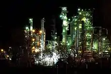
After the discovery of crude oil in the region during the 1890s, Casper became the regional petroleum industry center. Oil has figured prominently in its history from nearly the outset. Oil was first discovered in the famous Salt Creek Oil Field in 1889, approximately 40 miles (64 km) north of Casper; the first refinery in Casper was built in 1895. The city has featured a refinery ever since, although various refineries have been built and closed over the years. As recently as the early 1980s, the city was near or home to three refineries. The surviving one, operated by Sinclair Oil Corporation, is located nearby in Evansville. Development of Wyoming coal and uranium fields in recent decades has helped Casper continue its role as a center in the energy industry.
Casper Wind Farm began operations near Capser in Natrona County and has 11 turbines with a generating capacity of 16.5 MW.[24] Energy Transportation Inc. is headquartered in Casper. This logistics firm transports overweight and outsized components used in the wind power industry.[25] The Casper landfill is also a disposal site for windmill blades.[26]
Education
Casper is home to Casper College, a community college that offers bachelor's degrees in sixteen areas of study from the University of Wyoming through their UW/CC Center.[27]
Public education in the city of Casper is provided by Natrona County School District #1. The district operates sixteen elementary schools, five middle schools, and three high schools in Casper. The high schools include Kelly Walsh, Natrona County, and Roosevelt High Schools. A program called CAPS is being added to Natrona County School District, which will provide more space and classrooms for juniors and seniors at the three high schools.
Casper has a public library, a branch of the Natrona County Public Library System.[28]
Media
Casper is served by two print newspapers, the Casper Star-Tribune, a daily, and the Casper Journal, published weekly. Casper is also home to WyoFile, an online publication focusing on state issues.
Sports
- UFC 6 took place at the Casper Events Center in 1995.
- Casper hosted the AIFA Championship Bowl III at the Casper Events Center on July 26, 2009.[29][30]
- The Events Center has hosted the College National Finals Rodeo since 2001.
- The Casper Recreation Center offers basketball, fitness, racquetball, volleyball and is adjacent to the Casper Family Aquatics Center and Casper Ice Arena.[31]
- Soccer matches are held at the Casper Soccer Complex.[32]
- The Casper Municipal Golf Course is a public 27-hole golf course in Casper.[33]
Sports teams based in Casper include:
- Casper Cannibal RFC, an amateur rugby football team in the Eastern Rockies Rugby Football Union
- Casper Coyotes, a Junior A hockey team in the Western States Hockey League (WSHL), that plays out of the Casper Ice Arena[34]
- Casper Ghosts (formerly). From 2001-2011, Mike Lansing Field hosted the Ghosts of the Pioneer League, Rookie-level affiliate of the Colorado Rockies. In 2011, the team relocated to Grand Junction, Colorado to become the Rockies.
- Casper Horseheads, a collegiate summer baseball team of the Expedition League that started play in the summer of 2018, playing their home games at Mike Lansing Field.
Culture
Museums and historical sites
Casper is home to a number of museums and historical sites:
- Fort Caspar Museum and Historic Site[35]
- National Historic Trails Interpretive Center, a federally funded and operated museum[36]
- Nicolaysen Art Museum[37]
- Tate Geological Museum at Casper College[38]
- Werner Wildlife Museum[39]
- Wyoming Veterans Memorial Museum[40]
- The Science Zone [41]
- Historic Bishop Home [42]
Performing arts and music
Casper has three locations offering theater: the Gertrude Krampert Theatre at Casper College, Stage III Community Theatre, and the Casper Events Center[43] where an annual series of touring Broadway shows, Broadway in Casper, can be seen.
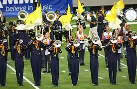
Casper is home to the Troopers,[44] a drum and bugle corps in Drum Corps International, and the Wyoming Symphony Orchestra.[45] During the summer months, Casper's City Band performs free concerts Thursday evenings at Washington Park, weather permitting.[43]
Transportation
Highways
 I-25 – North-South Interstate running from New Mexico to Wyoming.
 US 20 – East-West route through Casper that runs concurrent with I-25 through Casper. At exit 189 the highway continues west out of Casper, and no longer runs concurrent with the interstate. The business route of US 20 follows N. Beverly St. and Yellowstone Hwy. going East-West from I-25/US 87 (Exit 186) to U.S. 20-26 west of Casper in Mills.
 US 26 – East-West route through Casper that runs concurrent with I-25 through Casper. At exit 189 the highway continues west out of Casper, and no longer runs concurrent with the interstate. The business route of US 26 follows N. McKinley St. and Yellowstone Hwy. going East-West from I-25/US 87 (Exit 187) to U.S. 20-26 west of Casper in Mills.
 US 87 – North-South through Casper that runs concurrent with I-25 through Casper.
Wyoming State Highways:
 WYO 220 (N. Poplar St., CY Avenue) – East-West route from I-25/US 87 (Exit 188B) west out of Casper towards Alcova.
 WYO 251 (Wolcott St., Casper Mountain Rd.) – North-South route that continues south out of Casper and up Casper Mountain, eventually ending at WYO 487.
 WYO 252 (S. Poplar St.) – North-South route from the intersection of Poplar Street and CY avenue to Casper Mountain Road.
 WYO 254 (Salt Creek Hwy.) – North-South route from I-25/US 87 south to US 20-26 (Yellowstone Hwy.) in Mills.
 WYO 255 (Center St., 9th St., CY Avenue) – North-South route from I-25 exit 188A to the intersection of S. Poplar and CY Avenue, where CY Avenue continues as WY 220.
 WYO 258 (Wyoming Blvd.) – East-West loop route from I-25/US 87 to US 20-26 west of Casper in Mills; the majority of the highway runs along the southern borders of Casper.
Airports
The city has scheduled air service at Casper/Natrona County International Airport, a former army air base built during World War II. The current airport, having been built for bombers, has large runways and replaced a prior regional airport north of Casper which later became Bar Nunn. The airport is located west of the city just off of US highway 20/26. In July 2004, the airport facilities were renovated.[46] Passenger service at the airport is offered by United Express (SkyWest Airlines and GoJet Airlines), as well as Delta Connection (SkyWest Airlines), FedEx Express and FedEx Feeder provide cargo airline service to the airport.
Public transit
Public transit in the Casper area is provided by the Casper Area Transportation Coalition.[47] They offer fixed route service called The Bus and an on request service called CATC from Monday to Saturday.[48]
Scheduled bus service
Scheduled bus service once offered by Power River Bus Lines is now offered by ExpressArrow (formerly Black Hills Stages).
Notable people
- John Barrasso, Republican U.S. Senator from Wyoming[49]
- Zane Beadles, former Utah Ute offensive lineman; former member of the San Francisco 49ers[50]
- C. J. Box, author
- Tom Brewer, member of the Nebraska Legislature
- Tom Browning, former major league pitcher; threw perfect game; while with the Cincinnati Reds, won a World Series[51]
- Taven Bryan, professional football player
- Dick Cheney, US Vice-President and Secretary of Defense; CEO of Halliburton Company; grew up in Casper
- Liz Cheney, lawyer; member of U.S. State Department; daughter of Dick Cheney; attended elementary school in Casper; elected to the U.S. House of Representatives
- Lynne Cheney, wife of former Vice President Dick Cheney
- Tom Coburn, U.S. Senator from Oklahoma
- Barbara Cubin, former member of the U.S. House of Representatives; grew up and graduated from high school in Casper
- Mike Devereaux, professional baseball player with World Series rings with Los Angeles Dodgers and Atlanta Braves
- Ron Franscell, journalist and crime author
- Mary Meyer Gilmore, former Democratic member of the Wyoming House of Representatives
- Marlan Scully, physicist best known for his work in theoretical quantum optics
- Matthew Scully, author and speechwriter
- Matthew Shepard, murder victim for whom the Matthew Shepard Hate Crime Act is named
- Patrick Joseph Sullivan, mayor of Casper, Wyoming, 1897-1898; member of United States Senate from Wyoming, 1929-1930[52]
- Floyd Volker, professional basketball player
- Pete Williams, NBC News journalist covering the U.S. Justice Department
See also
References
- Mean monthly maxima and minima (i.e. the expected highest and lowest temperature readings at any point during the year or given month) calculated based on data at said location from 1981 to 2010.
- "City Council and Manager - City of Casper". City of Casper. Retrieved December 18, 2019.
- "City Manager - City of Casper". Casperwy.gov. Retrieved January 9, 2018.
- "2019 U.S. Gazetteer Files". United States Census Bureau. Retrieved August 7, 2020.
- "U.S. Census website". United States Census Bureau. Retrieved December 14, 2012.
- "Population and Housing Unit Estimates". United States Census Bureau. May 24, 2020. Retrieved May 27, 2020.
- "U.S. Census website". United States Census Bureau. Retrieved January 31, 2008.
- "US Board on Geographic Names". United States Geological Survey. October 25, 2007. Retrieved January 31, 2008.
- "Find a County". National Association of Counties. Archived from the original on May 31, 2011. Retrieved June 7, 2011.
- "City and Town Population Totals: 2010-2019". census.gov. Retrieved January 11, 2021.
- Fifer, Barbera. Wyoming's Historic Forts. Farcountry Press. pp. 59–68.
- "Platte River Fords". Wyoming State Historic Preservation Office.
- https://www.newspapers.com/image/348549405/. Missing or empty
|title=(help) - A History of the Origin of the Place Names in Nine Northwestern States. 1908. p. 128.
- "Wyoming Place Names". Annals of Wyoming. 15 (1): 85–90. January 1943.
- A History of the Chicago & North Western Railway System. 1910. p. 160.
- Christine Peterson. "More than a million people may have visited Wyoming for eclipse; one person came by sea plane". Trib.com. Retrieved January 9, 2018.
- "US Gazetteer files 2010". United States Census Bureau. Archived from the original on July 2, 2012. Retrieved December 14, 2012.
- "NOWData - NOAA Online Weather Data". National Oceanic and Atmospheric Administration. Retrieved July 8, 2020.
- "Station Name: WY CASPER-NATRONA COUNTY AP". National Oceanic and Atmospheric Administration. Retrieved July 8, 2020.
- "Casper, Wyoming, USA - Monthly weather forecast and Climate data". Weather Atlas. Retrieved July 4, 2019.
- "City and Town Population Totals: 2010-2019". United States Census Bureau. May 24, 2020. Retrieved May 27, 2020.
- "Historical Decennial Census Population for Wyoming Counties, Cities, and Towns". Wyoming Department of State / U.S. Census Bureau. Retrieved June 30, 2008.
- Moffatt, Riley. Population History of Western U.S. Cities & Towns, 1850-1990. Lanham: Scarecrow, 1996, 338.
- "Rocky Mountain Power's Wind Projects." Rocky Mountain Power. 2010. PDF Archived January 3, 2011, at the Wayback Machine.
- Transporting wind turbine components
- Martin, Chris (February 7, 2020). "Wind Turbine Blades Can't Be Recycled, So They're Piling Up in Landfills". Yahoo. Retrieved February 7, 2020.
- "UW: Bachelors Degree and Certificate Programs". University of Wyoming. Archived from the original on May 4, 2009. Retrieved July 15, 2009.
- "Wyoming Public Libraries". PublicLibraries.com. Retrieved June 13, 2019.
- "Casper Events Center". City of Casper. Archived from the original on October 27, 2010. Retrieved July 16, 2009.
- "Wyoming Cavalry News & Events". Wyoming Cavalry. Archived from the original on July 24, 2009. Retrieved July 16, 2009.
- "Casper Recreation Center". visitcasper.com. Archived from the original on April 24, 2019. Retrieved April 23, 2019.
- "Casper Soccer Complex". visitcasper.com. Archived from the original on April 24, 2019. Retrieved April 23, 2019.
- "Casper Municipal Golf Course". visitcasper.com. Archived from the original on April 24, 2019. Retrieved April 23, 2019.
- "Casper Coyotes – Casper Coyotes Junior Hockey". Caspercoyotes.com. Archived from the original on January 8, 2018. Retrieved January 9, 2018.
- "Fort Caspar Museum". City of Casper. Archived from the original on February 8, 2011. Retrieved July 15, 2009.
- "Trails Center". U.S. Bureau of Land Management. Archived from the original on August 17, 2010. Retrieved July 15, 2009.
- "Nicolaysen Art Museum & Discovery Center". Nicolaysen Art Museum & Discovery Center. Retrieved July 15, 2009.
- "Casper College". Casper College. Retrieved July 15, 2009.
- "Werner Wildlife Museum Review: Casper Best Attractions and Activities Reviews by 10Best". 10Best Inc. Archived from the original on January 16, 2013. Retrieved July 15, 2009.
- "Wyoming Veterans Museum".
- "The Science ZoneWhere everyone's a scientist !". The Science ZoneWhere everyone's a scientist !.
- "The Cadoma Foundation - Casper, WY - Historic Homes, Museum, Tours".
- "Arts and Culture". Casper Area Convention and Visitors Bureau. Archived from the original on June 9, 2009. Retrieved July 15, 2009.
- "Troopers — The Original 'America's Corps'". Troopers Drum & Bugle Corps. Archived from the original on June 19, 2009. Retrieved July 15, 2009.
- "Tickets". Wyoming Symphony Orchestra. Archived from the original on September 2, 2011. Retrieved July 15, 2009.
- "Airport renovations to start in July". Casper Star-Tribune. June 24, 2004. Retrieved February 24, 2008.
- "CATC — Casper Area Transportation Coalition". Casper Area Transportation Coalition, Inc. Retrieved August 18, 2009.
- "CATC — Casper Area Transportation Coalition". Casper Area Transportation Coalition, Inc. Retrieved August 18, 2009.
- "BARRASSO, John A. (1952 - )". Biographical Directory of the United States Congress. Retrieved November 18, 2012.
- "Zane Beadles". Pro-Football-Reference.Com. Retrieved November 18, 2012.
- "Tom Browning Stats". Baseball Almanac. Retrieved November 18, 2012.
- "SULLIVAN, Patrick Joseph (1865–1935)". Biographical Directory of the United States Congress. Retrieved November 18, 2012.
External links
| Wikimedia Commons has media related to Casper, Wyoming. |
| Wikivoyage has a travel guide for Casper. |
- City website
- Casper Star-Tribune
- Casper Convention & Visitors Bureau
- Casper Area Chamber of Commerce
- Casper recreation
Municipalities and communities of Natrona County, Wyoming, United States | ||
|---|---|---|
| City | 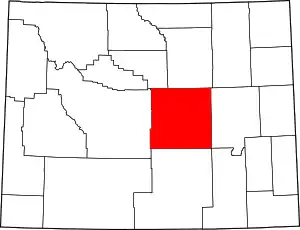 | |
| Towns | ||
| CDPs | ||
| Unincorporated communities | ||
| ||
| Authority control |
|---|