Zuni-Bandera volcanic field
Zuni-Bandera volcanic field (also known as Bandera lava field, Grants Malpais and Malpais volcanic field) is a volcanic field located in the state of New Mexico, United States.[1]
| Zuni-Bandera Volcanic Field | |
|---|---|
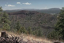 Bandera Crater in the center is part of the Zuni-Bandera lava field. | |
| Highest point | |
| Elevation | 8,366 ft (2,550 m) [1] |
| Coordinates | 34°48′00″N 108°00′00″W [1] |
| Geography | |
| Location | Cibola County, New Mexico, US |
| Geology | |
| Age of rock | 3.8 million years |
| Mountain type | Volcanic field[1] |
| Last eruption | 1170 BCE ± 300 years[1] |
The volcanic field has been considered for geothermal exploitation.[2]
It is on the Trails of the Ancients Byway, one of the designated New Mexico Scenic Byways.[3]
Origins
The Zuni-Bandera volcanic field lies along the Jemez Lineament, a zone of weakness in the lower crust and upper mantle that allows magma formed in the mantle to reach the surface.[4] The magmas erupted in the field includes both tholeiitic basalt (an iron-rich basalt with a low alkali content) and alkaline basalt. The tholeiitic basalt shows chemical and isotopic signatures of magma formed from the spinel-rich mantle rock of the lithosphere, the outer rigid shell of the Earth that includes the crust and uppermost mantle. The alkaline basalt, by contrast, formed from the garnet-rich mantle rock of the asthenosphere, the ductile region of the mantle just below the lithosphere. Little crustal material was assimilated into the magmas, although the tholeiitic magma experienced some fractional crystallization at shallow depths in the crust.[5]
Notable Vents
| Name | Elevation | Coordinates | Last eruption |
| Cerro Bandera[6][7] | 2,552 metres (8,373 ft) | 35.0°N 108.1°W | - |
| Bandera Crater[6][7] | 2,533 metres (8,310 ft) | 35.0°N 108.08°W | 9,500-10,900 years ago[8] |
| El Calderon[6][9] | 2,320 metres (7,612 ft) | 34.97°N 108.02°W | - |
| Cerro Colorado[6] | - | - | - |
| Cerro Encierro[6] | 2,298 metres (7,539 ft) | 34.88°N 108.05°W | - |
| Hoyo De Cibola[6] | 2,380 metres (7,808 ft) | 34.88°N 108.12°W | - |
| Cerro Hueco (Deer Mountain)[6] | 2,441 metres (8,009 ft) | - | - |
| Laguna[6] | - | - | - |
| Lost Woman[6] | 2,459 metres (8,068 ft) | 34.97°N 108.08°W | - |
| McCarty's Flow[7][10] | 2,244 metres (7,362 ft) | 35.0°N 107.8°W | 2,500-3,900 years ago[8] |
| Paxton Springs[6][7] | 2,490 metres (8,169 ft) | 35.07°N 108.07°W | - |
| Cerro Rendija[6][7] | 2,494 metres (8,182 ft) | 34.95°N 108.13°W | - |
| La Tetra (Cerro Tetra)[6] | 2,458 metres (8,064 ft) | 34.98°N 108.05°W | - |
| El Tintero[7] | 2,201 metres (7,221 ft) | - | - |
| Twin Craters[6] | 2,423 metres (7,949 ft) | 34.98°N 108.07°W | 15,800-17,800 years ago[8] |
References
- "Zuni-Bandera". Global Volcanism Program. Smithsonian Institution. Retrieved 2008-05-30.
- Laughlin, A.W.; West, F.G. (1975-12-01). Zuni Mountains, New Mexico as a potential dry hot rock geothermal energy Site (Report). United States Department of Energy. doi:10.2172/7366687. OSTI 7366687.
- "Trail of the Ancients". New Mexico Tourism Department. Archived from the original on August 21, 2014.
- Channer, Micheal A.; Ricketts, Jason W.; Zimmerer, Matthew; Heizler, Matthew; Karlstrom, Karl E. (1 October 2015). "Surface uplift above the Jemez mantle anomaly in the past 4 Ma based on 40Ar/39Ar dated paleoprofiles of the Rio San Jose, New Mexico, USA". Geosphere. 11 (5): 1384–1400. Bibcode:2015Geosp..11.1384C. doi:10.1130/GES01145.1.
- Peters, Timothy J.; Menzies, Martin; Thirlwall, Matthew; Kyle, Philip R. (April 2008). "Zuni–Bandera volcanism, Rio Grande, USA — Melt formation in garnet- and spinel-facies mantle straddling the asthenosphere–lithosphere boundary". Lithos. 102 (1–2): 295–315. Bibcode:2008Litho.102..295P. doi:10.1016/j.lithos.2007.08.006.
- "Zuni-Bandera - Synonyms and Subfeatures". Global Volcanism Program. Smithsonian Institution. Retrieved 2007-05-07.
- Ander, M.E.; Heiken, G.; Eichelberger, J.; Laughlin, A.W.; Huestis, S. (1981-05-01). Geologic and geophysical investigations of the Zuni-Bandera volcanic field, New Mexico (Report). United States Department of Energy, Los Alamos National Laboratory. doi:10.2172/6516124. OSTI 6516124.
- "Background on the Zuni-Bandera Volcanic Field". New Mexico Bureau of Geology and Mineral Resources. Retrieved 2009-06-30.
- "Into a Lava-Lined Underworld Near Albuquerque". The New York Times. 2014-08-28.
Additional lava caves reachable from El Calderon trailhead
- "McCartys Flow, Zuni - Bandera Volcanic Field, New Mexico". Volcano World. Retrieved 2007-05-08.