Óbuda-Békásmegyer
Óbuda-Békásmegyer is the 3rd district of Budapest, Hungary.
3rd District of Budapest
Budapest III. kerülete Óbuda-Békásmegyer | |
|---|---|
| District III | |
 Flag  Coat of arms | |
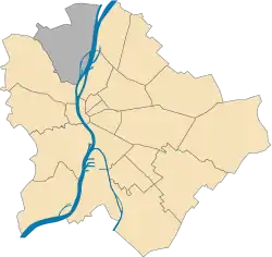
 Location of District III in Budapest (shown in grey) | |
| Coordinates: 47.5674°N 19.0370°E | |
| Country | Hungary |
| Region | Central Hungary |
| City | Budapest |
| Established | 17 November 1873 |
| Quarters[1] | List
|
| Government | |
| • Mayor | László Kiss (DK) |
| Area | |
| • Total | 39.7 km2 (15.3 sq mi) |
| Area rank | 3rd |
| Population (2016)[2] | |
| • Total | 130,415 |
| • Rank | 2nd |
| • Density | 3,285/km2 (8,510/sq mi) |
| Demonym(s) | harmadik kerületi ("3rd districter") |
| Time zone | UTC+1 (CET) |
| • Summer (DST) | UTC+2 (CEST) |
| Postal code | 1031 ... 1039 |
| Website | obuda |
History
Aquincum(a part of modern day Óbuda-Békásmegyer) was built here by the Roman Empire which existed from the 1st century to the 4th century. The settlement had a military and a separate civilian area. It had advanced infrastructure such as an aqueduct, a bath and two amfitheatres, one for the military and one for the civilians. Several villas belonged to the settlement, and the Roman governor had his palace on Hajógyári Island.
Politics
The current mayor of III. District of Budapest is László Kiss (DK).
The District Assembly, elected at the 2019 local government elections, is made up of 23 members (1 Mayor, 16 Individual constituencies MEPs and 6 Compensation List MEPs) divided into this political parties and alliances:[3]
| Party | Seats | Current District Assembly | ||||||||||||||||
|---|---|---|---|---|---|---|---|---|---|---|---|---|---|---|---|---|---|---|
| Opposition coalition[lower-alpha 1] | 16 | M | ||||||||||||||||
| BB Óbudáért-Fidesz-KDNP | 6 | |||||||||||||||||
List of mayors
| Member | Party | Date | |
|---|---|---|---|
| István Tarlós | SZDSZ | 1990–2006 | |
| Ind. | |||
| Balázs Bús | Fidesz | 2006–2019 | |
| László Kiss | DK | 2019– | |
Twin towns
Óbuda-Békásmegyer is twinned with:
References
- "94/2012. (XII. 27.) Főv. Kgy. rendelet - a közterület- és városrésznevek megállapításáról, azok jelöléséről, valamint a házszám-megállapítás szabályairól" (in Hungarian).
- "A fővárosi kerületek, a megyei jogú városok, a városok területe, lakónépessége és a lakások száma" [The area of districts of the capital, of the towns with county's rights, resident population and number of dwellings]. Magyarország közigazgatási helynévkönyve 2016. január 1 [Gazetteer of Hungary 1 January, 2016] (PDF). Hungarian Central Statistical Office. 2016. p. 21.
- "Városi közgyűlés tagjai 2019-2024 - Budapest III. kerület". valasztas.hu. Retrieved 30 October 2019.
- "Testvérvárosaink" (in Hungarian). Óbuda-Békásmegyeri Önkormányzat. Retrieved 24 October 2019.
External links
| Wikimedia Commons has media related to Óbuda-Békásmegyer. |
| Wikivoyage has a travel guide for Óbuda. |
