Ōgata, Akita
Ōgata (大潟村, Ōgata-mura) is a village located in Akita Prefecture, Japan. As of 31 January 2020, the village had an estimated population of 3,164 in 1122 households,[1] and a population density 19 persons per km². The total area of the village is 170.11 square kilometres (65.68 sq mi).
Ōgata
大潟村 | |
|---|---|
 Ōgata Village Office | |
 Flag  Seal | |
 Location of Ōgata in Akita Prefecture | |
 Ōgata Location of Ōgata in Akita Prefecture | |
| Coordinates: 40°1′4.1″N 139°57′35.8″E | |
| Country | Japan |
| Region | Tōhoku |
| Prefecture | Akita |
| District | Minamiakita |
| Government | |
| • Mayor | Hiroto Takahashi |
| Area | |
| • Total | 170.11 km2 (65.68 sq mi) |
| Population (February 2020) | |
| • Total | 3,164 |
| • Density | 19/km2 (48/sq mi) |
| Time zone | UTC+9 (Japan Standard Time) |
| - Tree | Japanese Black Pine |
| - Flower | Scarlet Sage |
| - Bird | Swan |
| Phone number | 0185-45-2111 |
| Address | 1-1 Chūō, Ōgata-mura, Minamiakita-gun, Akita-ken 010-0494 |
| Website | Official website |
Geography
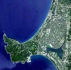
Ōgata is located northwestern Akita Prefecture. The village consists entirely of land reclaimed from the former Lake Hachirōgata, and as a consequence is flat, and mostly below sea level.
Neighboring municipalities
- Akita Prefecture
History
Ōgata village was officially founded on October 1, 1964. The village stands on the former Hachirōgata lagoon, which was reclaimed as the occupation government of Japan after the Second World War had an ambition to create new farmland in order to secure a stable domestic supply of rice.
The Hachirōgata lagoon was the second largest lake in Japan and an ideal candidate for extensive land land reclamation with its shallow waters. Land reclamation work began at Hachirōgata in April 1957 and during the next twenty years, with the help of Dutch engineers, around seventeen thousand hectares of new farmland were created.
Between 1967 and 1974 about 580 settlers took up residence in the new village of Ōgata - bringing their families with them.[2]
Demographics
Per Japanese census data,[3] the population of Ōgata has remained relatively steady over the past 40 years.
| Year | Pop. | ±% |
|---|---|---|
| 1960 | 0 | — |
| 1970 | 1,640 | — |
| 1980 | 3,334 | +103.3% |
| 1990 | 3,286 | −1.4% |
| 2000 | 3,323 | +1.1% |
| 2010 | 3,218 | −3.2% |
Climate
Ōgata has a Humid continental climate (Köppen climate classification Cfa) with large seasonal temperature differences, with warm to hot (and often humid) summers and cold (sometimes severely cold) winters. Precipitation is significant throughout the year, but is heaviest from August to October. The average annual temperature in Ōgata is 11.3 °C. The average annual rainfall is 1565 mm with September as the wettest month. The temperatures are highest on average in August, at around 25.1 °C, and lowest in January, at around -0.6 °C.[4]
Economy
The economy of Ōgata is based on agriculture, mostly on the cultivation of rice.
Education
Ōgata has one public elementary school and one public middle school operated by the village government. The village does not have a high school.
Transportation
Ōgata is not served by any railways or highways.
Local attractions
- Ogata Fuji
- Cherry and Rapeseed Blossom Road
- Polder Museum of Ogata-mura
- Ogata Moor Onsen
- Hotel Sun Rural Ogata
- KATA Farmer's Market
- Seitaikei Park
- Wild Bird Observation Station
- South Pumping Station
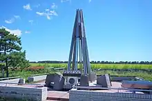
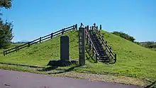
- Hachirōgata Reclamation Monument
- Latitude and Longitude Intersection Monument
- South Pond Park (Minami no Ike)
- Ground Golf Course
- The NHK Ōgata Transmitter (used for transmissions on 774 kHz with a power of 500 kW)
Local events
Hachirogata Reclamation Memorial Ekiden Relay Race
A relay race held at the beginning of September every year to commemorate the reclamation ceremony of September 15th 1964.
New Rice Harvest Festival in Ogata
Rice tasting and sale of rice and other agricultural products.
Ogata Shrine Reitaisai Festival
Shinto festival, which takes place every year on September 10th to pray for a good harvest. The procession makes its way around the village on its way to the shrine.
Ogata Arts and Culture Festival
The artistic and cultural groups of Ōgata display their works or perform.
World Econo Move
Annual solar and electric vehicle race held in August at the Ōgata Solar Sports Line since 1993.
The village is known internationally for these Solar-car and Eco-car races.
Akita Prefectural Rowing Competition - Summer Regatta
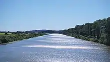
Regatta held in July at the Ogata Rowing Course for village locals. The winning team qualifies for the national regatta.
Oga Peninsula and Ogata Geopark
In September 2011, Ōgata and Oga City were approved as a joint member of the Japan Geopark Network.
Approximately 30km on each side, the relatively compact geopark contains the history of the earth spanning 70 million years into the past, observable complete stratum in near succession, including the separation of the Japanese archipelago from the continent, the formation of the Sea of Japan, and environmental changes due to large-scale climate change that continue through the present day. Also, born from "Hachirogata" the former largest lagoon in Japan, Ōgata is Japan's largest land reclamation.
References
- Ōgata village official statistics (in Japanese)
- Wood, Donald C. (2015). Ogata-mura : sowing dissent and reclaiming identity in a japanese farming village. New York: Berghahn Books. ISBN 1-78533-044-6. OCLC 920867174.
- Ōgata population statistics
- Ōgata climate data
- "International Exchange". List of Affiliation Partners within Prefectures. Council of Local Authorities for International Relations (CLAIR). Retrieved 21 November 2015.
External links
![]() Media related to Ogata, Akita at Wikimedia Commons
Media related to Ogata, Akita at Wikimedia Commons
- Official Website (in Japanese)
| Core city | ||
|---|---|---|
| Cities | ||
| Districts | ||
| Authority control |
|---|