Fujisato, Akita
Fujisato (藤里町, Fujisato-machi) is a town located in Akita, Japan. As of 31 January 2020, the town had an estimated population of 3,180 in 1354 households,[1] and a population density of 11 persons per km². . The total area of the town is 281.98 square kilometres (108.87 sq mi).
Fujisato
藤里町 | |
|---|---|
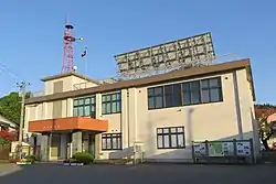 Fujisato Town Hall | |
 Flag  Seal | |
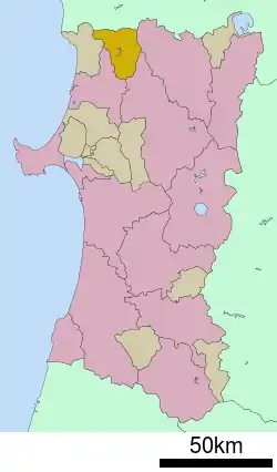 Location of Fujisato in Akita Prefecture | |
 Fujisato | |
| Coordinates: 40°17′N 140°16′E | |
| Country | Japan |
| Region | Tōhoku |
| Prefecture | Akita |
| District | Yamamoto |
| Area | |
| • Total | 281.98 km2 (108.87 sq mi) |
| Population (January 2020) | |
| • Total | 3,180 |
| • Density | 11/km2 (29/sq mi) |
| Time zone | UTC+9 (Japan Standard Time) |
| City symbols | |
| • Tree | Fagus crenata |
| • Flower | Wisteria floribunda |
| • Bird | Black woodpecker |
| Phone number | 0185-79-2111 |
| Address | Fujigoto 8, Fujigoto-aze Fujisato-machi, Yamamoto-gun, Akita-ken 018-3201 |
| Website | Official website |
Geography
Fujisato is located at the far northwestern of Akita Prefecture, bordered by the World Heritage Site Shirakami Mountains to the south, and by Aomori Prefecture to the north. The town itself is nestled in a small valley at the base of the Shirakami Mountains. The hillsides are brimming with lush green in the summer, amazing orange in the autumn, and covered in white snow during the winter. Due to its location in the middle of the mountains, the temperature in Fujisato can get remarkably cold at night, with snowfall tending to be somewhat greater than that in neighboring municipalities.
History
The area of present-day Fujisato was part of ancient Dewa Province, dominated by the Satake clan during the Edo period, who ruled Kubota Domain under the Tokugawa shogunate. The area was organized into villages within Yamamoto District, Akita with the establishment of the modern municipalities system on April 1, 1884. The village of Fujisato was established on March 31, 1955 from the merger of the villages of Fujigoto and Kasuge, both from Yamamoto District. It was raised to town status on November 1, 1963.
Demographics
Per Japanese census data,[2] the population of Fujisato peaked at around the year 1950 and has been in steady decline since then.
| Year | Pop. | ±% |
|---|---|---|
| 1920 | 6,797 | — |
| 1930 | 6,882 | +1.3% |
| 1940 | 7,028 | +2.1% |
| 1950 | 8,982 | +27.8% |
| 1960 | 8,642 | −3.8% |
| 1970 | 6,769 | −21.7% |
| 1980 | 5,837 | −13.8% |
| 1990 | 5,291 | −9.4% |
| 2000 | 4,708 | −11.0% |
| 2010 | 3,837 | −18.5% |
Climate
Fujisato has a Humid continental climate (Köppen climate classification Cfa) with large seasonal temperature differences, with warm to hot (and often humid) summers and cold (sometimes severely cold) winters. Precipitation is significant throughout the year, but is heaviest from August to October. The average annual temperature in Fujisato is 10.3 °C. The average annual rainfall is 1471 mm with September as the wettest month. The temperatures are highest on average in August, at around 24.3 °C, and lowest in January, at around -2.1 °C.[3]
Economy
The economy of Fujisato is based on agriculture.
Education
Fujisato has one public elementary school and one public middle school operated by the town government. The town does not have a high school.
Transportation
Fujisato is not served by either rail connections, or the Japanese national highway system. Access is primarily through Akita Prefectural Road 200 or 317.
References
External links
![]() Media related to Fujisato, Akita at Wikimedia Commons
Media related to Fujisato, Akita at Wikimedia Commons
- Official Website (in Japanese)
| Core city | ||
|---|---|---|
| Cities | ||
| Districts | ||
| Authority control |
|---|