Ōtsuki, Yamanashi
Ōtsuki (大月市, Ōtsuki-shi) is a city located in Yamanashi Prefecture, Japan. As of 1 July 2019, the city had an estimated population of 23,976 in 10404 households,[1] and a population density of 86 persons per km2. The total area of the city is 380.25 square kilometres (146.82 sq mi).
Ōtsuki
大月市 | |
|---|---|
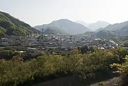 Panoramic view of Ōtsuki City, from Mount Iwadono | |
 Flag  Seal | |
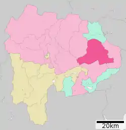 Location of Ōtsuki in Yamanashi Prefecture | |
 Ōtsuki | |
| Coordinates: 35°36′38″N 138°56′24″E | |
| Country | Japan |
| Region | Chūbu |
| Prefecture | Yamanashi |
| Government | |
| • Mayor | Yukio Ishii (from August 2007) |
| Area | |
| • Total | 280.25 km2 (108.21 sq mi) |
| Population (July 1, 2019) | |
| • Total | 23,976 |
| • Density | 86/km2 (220/sq mi) |
| Time zone | UTC+9 (Japan Standard Time) |
| - Tree | Yaezakura (Prunus lannesiana) |
| - Flower | Lilium auratum |
| Phone number | 0554-22-2111 |
| Address | 2-6-20 Ōtsuki, Ōtsuki-shi, Yamanashi-ken 401-8601 |
| Website | Official website |
Geography
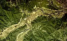
Ōtsuki is located in eastern Yamanashi Prefecture, approximately 80 kilometers from Tokyo. the city is located in the Chichibu and the Tanzawa Mountains and the Sagami River (known locally as the Katsura River) flows through the city.
Demographics
Per Japanese census data,[2] the population of Ōtsuki has been declining for the past 50 years.
| Year | Pop. | ±% |
|---|---|---|
| 1940 | 31,830 | — |
| 1950 | 41,650 | +30.9% |
| 1960 | 39,783 | −4.5% |
| 1970 | 36,858 | −7.4% |
| 1980 | 35,404 | −3.9% |
| 1990 | 34,941 | −1.3% |
| 2000 | 33,124 | −5.2% |
| 2010 | 28,126 | −15.1% |
Climate
The city has a climate characterized by characterized by hot and humid summers, and relatively mild winters (Köppen climate classification Cfa). The average annual temperature in Ōtsuki is 11.2 °C. The average annual rainfall is 1523 mm with September as the wettest month. The temperatures are highest on average in August, at around 23.5 °C, and lowest in January, at around -0.5 °C.[3]
History
Located in the headwaters of the Sagami River, the area around present-day Ōtsuki was heavily settled in the Jōmon period, and over 80 Jōmon sites have been found within city limits. However, there are fewer Yayoi period sites. During the Nara period ritsuryo organization of Kai Province, the area came under Tsuru County. From the middle of the Kamakura period, much of the province came under the control of the Takeda clan.
During the Edo period, all of Kai Province was tenryō territory under direct control of the Tokugawa shogunate, although the portion around modern day Ōtsuki was part of the short-lived Tamimura Domain, which was suppressed in 1704. Also during the Edo period, the Kōshū Kaidō, one of the Edo Five Routes, passed through Ōtsuki, which with 12 of the 45 post stations has more post stations than any other municipality in Japan. The eleven post stations spread from Shimotorisawa-shuku to Kuronoda-shuku.
During the cadastral reform of the early Meiji period on July 1, 1889, the village of Hirosato was created within Kitatsuru District, Yamanashi Prefecture. On April 1, 1933 the village was raised to town status, and renamed Ōtsuki. The town was bombed by the United States on August 13, 1945, only two days before the end of World War II. The town was elevated to city status on August 8, 1954 by merging with the neighboring towns of Saruhashi and Nanaho and the villages of Sasago, Nigioka, Hatsukari and Yanagawa.
Government
Ōtsuki has a mayor-council form of government with a directly elected mayor and a unicameral city legislature of 12 members.
Economy
Ōtsuki was noted traditionally for its production of fine silk. In the modern period, it became the location of numerous factories producing synthetic fibers.
Education
- Ohtsuki City College
- Ōtsuki has five public elementary schools and two public middle schools operated by the city government and two public high schools operated by the Yamanashi Prefectural Board of Education.
Transportation
Railway
Sister city relations
.svg.png.webp) Fraser Coast, Queensland, Australia[4]
Fraser Coast, Queensland, Australia[4]
Local attractions
- Saruhashi - A famous historical bridge and designated National Place of Scenic Beauty
- Yatsuzawa Power Station
Notable people
- Masanori Murakami – former professional baseball player
- Masahide Kobayashi – former professional baseball player
References
- Ōtsuki City official statistics(in Japanese)
- Ōtsuki population statistics
- Ōtsuki climate data
- "International Exchange". List of Affiliation Partners within Prefectures. Council of Local Authorities for International Relations (CLAIR). Retrieved 21 November 2015.
External links
| Wikimedia Commons has media related to Ōtsuki, Yamanashi. |
| Wikivoyage has a travel guide for Otsuki. |
- Official Website (in Japanese)
| Authority control |
|---|