Hayakawa, Yamanashi
Hayakawa (早川町, Hayakawa-chō) is a town located in Yamanashi Prefecture, Japan. As of 1 June 2019, the town had an estimated population of 1,050 in 610 households,[1] and a population density of 2.8 persons per km2. The total area of the town is 369.86 square kilometres (142.80 sq mi). It has the smallest population of any town in Japan. Hayakawa is on the list of The Most Beautiful Villages in Japan, established in 2005.
Hayakawa
早川町 | |
|---|---|
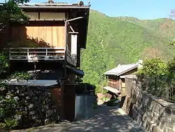 Akasawa district in Hayakawa Town | |
 Flag  Seal | |
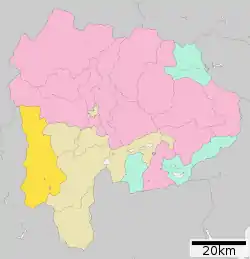 Location of Hayakawa in Yamanashi Prefecture | |
 Hayakawa | |
| Coordinates: 35°25′N 138°22′E | |
| Country | Japan |
| Region | Chūbu Tōkai |
| Prefecture | Yamanashi Prefecture |
| District | Minamikoma |
| Government | |
| • Mayor | Kazuyoshi Tsuji (since November 1980) |
| Area | |
| • Total | 369.86 km2 (142.80 sq mi) |
| Population (June 1, 2019) | |
| • Total | 994 |
| • Density | 2.7/km2 (7.0/sq mi) |
| Time zone | UTC+9 (Japan Standard Time) |
| City symbols | |
| • Tree | Cercidiphyllum japonicum |
| • Flower | Rhododendron |
| • Bird | Crested kingfisher |
| • Mammal | Sika deer |
| Phone number | 0556-45-2511 |
| Address | 758 Koju Hayakawa-cho Minimikoma-gun, Yamanashi-ken 409-2702 |
| Website | Official website |

Geography
Hayakawa is located in far southwestern Yamanashi Prefecture. The Hayakawa River, a tributary of the Fuji River runs through the town. Some 96% of the town's area is covered by forest and mountains.
Neighboring municipalities
Yamanashi Prefecture
Shizuoka Prefecture
Demographics
Per Japanese census data,[2] the population of Hayakawa has decreased drastically over the past 50 years. Over 40% of the town population shares the surname of "Mochizuki".
| Year | Pop. | ±% |
|---|---|---|
| 1940 | 7,143 | — |
| 1950 | 7,262 | +1.7% |
| 1960 | 10,679 | +47.1% |
| 1970 | 4,862 | −54.5% |
| 1980 | 3,005 | −38.2% |
| 1990 | 2,269 | −24.5% |
| 2000 | 1,740 | −23.3% |
| 2010 | 1,247 | −28.3% |
Climate
The town has a climate characterized by hot and humid summers, and relatively mild winters (Köppen climate classification Cfa). The average annual temperature in Hayakawa is 13.0 °C. The average annual rainfall is 1655 mm with September as the wettest month. The temperatures are highest on average in August, at around 24.9 °C, and lowest in January, at around 1.5 °C.[3]
History
During the Edo period, all of Kai Province was tenryō territory under direct control of the Tokugawa shogunate. During the cadastral reform of the early Meiji period, the area was organized into villages under Minamikoma District, Yamanashi. The town of Hayakawa was created on September 23, 1956 through the merger of six villages of Motivate, Goka, Suzurishima, Miyakogawa, Misato and Nishiyama.
Education
Hayakawa has two public elementary schools and one public junior high school operated by the town government. The village does not have a high school.
Transportation
Railway
The town has no passenger rail service. The nearest train station is Minobu Station on the Minobu Line, with bus services very infrequently.
Highway
Hayakawa is not served by any national highway.
References
- [Hayakawa Town official statistcs] (in Japanese)
- Hayakawa population statistics
- Hayakawa climate data
External links
![]() Media related to Hayakawa, Yamanashi at Wikimedia Commons
Media related to Hayakawa, Yamanashi at Wikimedia Commons
- Official Website (in Japanese)
| Authority control |
|---|
