Kai, Yamanashi
Kai (甲斐市, Kai-shi) is a city located in Yamanashi Prefecture, Japan. As of 31 May 2019, the city had an estimated population of 75,706,[1] and a population density of 1,100 persons per km². The total area of the city is 71.95 square kilometres (27.78 sq mi).
Kai
甲斐市 | |
|---|---|
 Kai City Hall | |
 Flag  Emblem | |
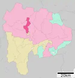 Location of Kai in Yamanashi Prefecture | |
 Kai | |
| Coordinates: 35°39′38.9″N 138°30′56.8″E | |
| Country | Japan |
| Region | Chūbu (Tōkai) |
| Prefecture | Yamanashi Prefecture |
| Area | |
| • Total | 71.95 km2 (27.78 sq mi) |
| Population (April 30, 2019) | |
| • Total | 75,706 |
| • Density | 1,100/km2 (2,700/sq mi) |
| Time zone | UTC+9 (Japan Standard Time) |
| City symbols | |
| • Tree | Zelkova serrata |
| • Flower | Sakura |
| Phone number | 055-276-2111 |
| Address | 2610 Shinohara, Kai-shi, Yamanashi 400-0395 |
| Website | Official website |
Geography
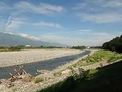
Kai is located in central Yamanashi Prefecture, orientated north-south along the banks of the Fuji River.
Demographics
Per Japanese census data,[2] the population of Kai has grown rapidly over the past 40 years.
| Year | Pop. | ±% |
|---|---|---|
| 1940 | 17,777 | — |
| 1950 | 24,497 | +37.8% |
| 1960 | 22,951 | −6.3% |
| 1970 | 27,075 | +18.0% |
| 1980 | 45,337 | +67.4% |
| 1990 | 60,765 | +34.0% |
| 2000 | 71,706 | +18.0% |
| 2010 | 73,816 | +2.9% |
Climate
The city has a climate characterized by characterized by hot and humid summers, and relatively mild winters (Köppen climate classification Cfa). The average annual temperature in Kai is 14.3 °C. The average annual rainfall is 1240 mm with September as the wettest month. The temperatures are highest on average in August, at around 26.7 °C, and lowest in January, at around 2.4 °C.[3]
History
The area of present day Kai was part of ancient Kai Province and have numerous Jomon period ruins. During the Sengoku period, warlord Takeda Shingen built embankments on the Kamanashi River for flood control and to open up new rice lands. During the Edo period, all of Kai Province was tenryō territory under direct control of the Tokugawa shogunate.
The city of Kai was established on September 1, 2004, from the merger of the town of Futaba (from Kitakoma District), and the towns of Ryūō and Shikishima (both from Nakakoma District). It takes its name from the old name for Yamanashi Prefecture, Kai Province.
Government
Kai has a mayor-council form of government with a directly elected mayor and a unicameral city legislature of 15 members.
Education
Kai has eleven public elementary schools and five public middle schools operated by the city government and one public high school operated by the Yamanashi Prefectural Board of Education.
Transportation
Railway
Sister city relations
 Keokuk, Iowa, USA[4]
Notable people
- Shin Nakagomi – professional baseball player
- Youichi Imamura – professional racecar driver
- Karin Ogino – former idol
References
- Kai city official statistics (in Japanese)
- Kai population statistics
- Kai climate data
- "International Exchange". List of Affiliation Partners within Prefectures. Council of Local Authorities for International Relations (CLAIR). Archived from the original on 5 February 2016. Retrieved 21 November 2015.
External links
![]() Media related to Kai, Yamanashi at Wikimedia Commons
Media related to Kai, Yamanashi at Wikimedia Commons
- Official Website (in Japanese)
