Nirasaki, Yamanashi
Nirasaki (韮崎市, Nirasaki-shi) is a city in Yamanashi Prefecture, Japan. As of 1 June 2019, the city had an estimated population of 29,483 in 12662 households,[1] and a population density of 210 persons per km². The total area is 132.69 square kilometres (51.23 sq mi).[2]
Nirasaki
韮崎市 | |
|---|---|
 Ganjo-ji temple in Nirasaki | |
 Flag  Seal | |
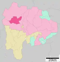 Location of Nirasaki in Yamanashi Prefecture | |
 Nirasaki | |
| Coordinates: 35°42′31.9″N 138°26′46.1″E | |
| Country | Japan |
| Region | Chūbu (Kantō) |
| Prefecture | Yamanashi |
| Government | |
| • Mayor | Komei Yokouchi (since November 2006) |
| Area | |
| • Total | 143.69 km2 (55.48 sq mi) |
| Population (June 1, 2019) | |
| • Total | 29,483 |
| • Density | 210/km2 (530/sq mi) |
| Time zone | UTC+9 (Japan Standard Time) |
| -Tree | Cherry blossom |
| -Flower | Zelkova serrata |
| -Bird | Falco tinnunculus |
| Phone number | 0551-22-1111 |
| Address | 1-3-1 Suijin, Nirasaki-shi, Yamanashi-ken 407-8501 |
| Website | Official website |

Geography
Nirasaki is located in the northwestern end of the Kofu Basin in Yamanashi Prefecture, bordered to the east by the Minami Alps National Park and the west by the Minami Alps Koma Prefectural Natural Park.
Demographics
Per Japanese census data,[3] the population of Nirasaki has increased over the past 30 years.
| Year | Pop. | ±% |
|---|---|---|
| 1940 | 25,804 | — |
| 1950 | 33,469 | +29.7% |
| 1960 | 30,244 | −9.6% |
| 1970 | 27,267 | −9.8% |
| 1980 | 27,343 | +0.3% |
| 1990 | 29,766 | +8.9% |
| 2000 | 32,707 | +9.9% |
| 2010 | 43,483 | +32.9% |
Climate
The city has a climate characterized by characterized by hot and humid summers, and relatively mild winters (Köppen climate classification Cfa). The average annual temperature in Nirasaki is 13/0 °C. The average annual rainfall is 1278 mm with September as the wettest month.[4]
History
The area around present-day Nirasaki was the ancestral homeland of the Takeda clan, which dominated Kai Province in the Sengoku period. During the Edo period, the area was tenryō territory under the direct administration of the Tokugawa shogunate, and the village of Niirasaki was a post town on the Kōshū Kaidō highway. During the early Meiji period, the area was organized into 14 villages under Kitakoma District, Yamanashi. Nirasaki was elevated to town status on September 20, 1892. Modern Nirasaki City was founded by merger of Nirasaki with ten surrounding villages on October 10, 1954.[5]
Government
Nirasaki has a mayor-council form of government with a directly elected mayor and a unicameral city legislature of 18 members.
Economy
The economy of Nirasaki is primarily agricultural.
Education
Nirasaki has five public elementary schools and two public middle schools operated by the city government and two public high schools operated by the Yamanashi Prefectural Board of Education.
Transportation
Railway
Sister city relations
 – Fairfield, California, USA[6]
 – Jiamusi, Heilongjiang, China[7]
Local attractions
- Site of Shinpu Castle, Takeda Hachiman-gu, Ganjo-ji
- Site of Hakusan Castle
- Nirasaki Asahi onsen
- Nirasaki Ōmura Art Museum
Notable people
- Ichizō Kobayashi, industrialist
- Azuma Koshiishi, politician
- Satoshi Omura, scientist
References
- Nirasaki City official Statistcs(in Japanese)
- "Nirasaki official home page".
- Nirasaki population statistics
- Nirasaki climate data
- "Nirasaki official timeline" (PDF). Archived from the original on 2015-06-17. Retrieved 2016-01-17.
- "City of Fairfield,CA - Sister City Program". City of Fairfield. Retrieved July 27, 2017.
- "International Exchange". List of Affiliation Partners within Prefectures. Council of Local Authorities for International Relations (CLAIR). Archived from the original on 5 February 2016. Retrieved 21 November 2015.
External links
| Wikimedia Commons has media related to Nirasaki, Yamanashi. |
- Official Website (in Japanese)
| Authority control |
|---|